Ferdinand "Jelly Roll" Morton (ca. October 20, 1890 – July 10, 1941) was an American ragtime and early jazz pianist, bandleader and composer, says Wikipedia.
Widely recognized as a pivotal figure in early jazz, Morton claimed, in self-promotional hyperbole, to have invented jazz outright in 1902. Critic Scott Yanow[1] writes that "Morton did himself a lot of harm posthumously by exaggerating his worth [yet] Morton's accomplishments as an early innovator are so vast that he did not really need to stretch the truth."
Morton was the first serious composer of jazz, naming and popularizing the so-called "Spanish tinge" of exotic rhythms and penning such standards as "Wolverine Blues", "Black Bottom Stomp", and "Buddy Boldens Blues".
As well as a tune called "Shreveport Stomp."
Monday, August 31, 2009

Graphing US demographics: ethnic breakdown
Basic geography: make a circle graph using the most important of these figures.
Figures on American ethnic groups from Wikipedia via the US Census Bureau:
White 74% 221.3 million
Hispanic or Latino ethnicity, of any race 14.8% about 44.3 million
Black or African American alone 13.4% 40.9 million
Some other race alone 6.5% 19 million
Asian alone 4.4% 13.1 million
Two or more races 2.0% 6.1 million
American Indian or Alaska Native alone 0.68% 2.0 million
Native Hawaiian or other Pacific Islander alone 0.14% 0.43 million
The background of place names such as York
It's fun and part of your academic development to inquire into the origin and meaning of place names such as York / New York. In what part of the UK is York?
* Pennsylvania: meaning of sylvan?
* New Jersey: see the British island called Jersey off the coast of France.
* Vermont: what color? what terrain?
* Who was Henry Hudson? What was the point of his exploration of bays on the East Coast?
* Recently a NY Times reporter went up the Hudson to celebrate 400 years since the exploration. About 50 miles upstream from the city he passed a famous military institution called __ __ .
Ramadan Mubarak! Translate?
Salaam! (or Salaam Alyeikum). Translate.
Indigenous: Originating and living or occurring naturally in an area or environment.
* Chili peppers are indigenous to Mexico and Central America.
* The indigenous peoples of North La are the Caddo tribe.
Sunday, August 30, 2009
River studies: journey up the Hudson with a NY Times reporter to re-trace the voyage of Henry Hudson and the Half Moon
Please see Hudson River exploration video at the NY Times.
Of this photo, says the photog:
"In honor of the 400th anniversary of Henry Hudson's voyage up the river that now bears his name and the beginning of the colonization of New Amsterdam and other cities along the Hudson River by the Dutch a fleet of replica ships including the "HALF MOON" sailed up the Hudson River today, June 6th. This voyage started in New York Harbor at the Statue of Liberty and will end in Albany. There are various stops scheduled along the way.
I took these photos underneath the George Washington Bridge with the New Jersey Palisades in the background. It's hard to imagine what this area looked like 400 years ago but the Palisades are the closest thing that we have to the tree covered shoreline that must have greeted Henry Hudson."
A highly-recommended source for Magnet social studies students: About.com
About.com is a site that addresses a very wide array of topics at a level highly appropriate for our class needs. Please begin to regularly search
http://geography.about.com/ in work for this class.
Examples:
* See more on the Mississippi Valley.
* See more on the Erie Canal.

http://geography.about.com/ in work for this class.
Examples:
* See more on the Mississippi Valley.
* See more on the Erie Canal.
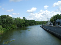
Project due Tues, Sept 8: Comparing the Erie Canal-Hudson River Waterway to the Mississippi River System

Overlooking Downtown Yonkers as Ship Sails Up Hudson River at Dusk
Originally uploaded by Nino.Modugno
Comparing the meaning of the Erie Canal-Hudson River waterway and the Mississippi Valley in a 2-sheet graphic project.
- Sketch the river systems on 2 adjacent sheets in your notebook. Label key cities, relevant states and major landmarks (4 pts).
- Neatness counts - it is a 2-point factor. Use color. Careful lettering. Check spelling.
- Between the 2 maps, create a comparison chart that includes a labeled 1) circle graph 2) line graph 3) bar graph (2 pts ea). These graphs may address factors such as -
* size (length, aggregate length),
* demographics (aggregate states' populations),
* economic activity (cargo, etc)
* issues (flood control, pollution).
* history (brief review of important dates)
You must choose the material to be used in each graph. Advanced and imaginative students may earn bonus points by adding relevant material beyond my guidelines.
- Documentation - sources - at page bottom (2 pts).
- At the top: Snazzy title! Also, an explanatory subtitle (2 pts).
Water giveth, water taketh away: week of Aug 31 to Sept 4
Water will become one of the great issues for voters in the next few decades.
* How do we secure an adequate supply of drinking water? You may be aware that much of the world continues to be hampered by a crippling lack of virus-free water.
* How do we balance environmental concerns, such as the negative impact of building a dam, with the public's need for affordable water?
* How do we address global warming trends and the growing effect on water supply and on water levels?
This week's issues -
a) Louisiana's alarming loss of coastal wetlands.
b) The lessons learned about water in the aftermath of Hurricane Katrina.
c) Water is wealth: Gulf coast estuaries.
d) Water, the hidden factor in the excitement over the Haynesville Shale natural gas deposits.
Thurs:
* Hand-sketched map quiz on the Great Lakes and the New York state region. Label and sketch 13 items: 5 lakes, 6 states, 1 ocean, 1 neighboring nation. Total 16 pts.
* Open notes multiple choice quiz based on web site notes. 12 questions. 12 pts.
Friday, August 28, 2009
Water and wealth: the story of the Erie Canal
When the people of NY state agreed to build the Erie Canal (early 1800's) they began to connect the resources of the Great lakes region (ore, timber, furs, mfg goods, etc) to NYC harbor, one of the world's great crossroads of trade.
The Erie Canal connected to the Hudson River, which flowed into NY harbor.
Wealth was created for people all along the Hudson valley and along the almost 400-mile length of the Erie Canal. The wealth of Great Lakes farmers and traders was also increased. Most of all, it helped the harbor at NYC become one of the world's richest ports.
Map sketch -
* 5 Great lakes (don't foget Mrs. Smheo)
* 6 states (the 5 states surrounding NY)
* Atlantic
* Canada
- Map quiz, 13 items, on Thurs.
How Louisiana and Shreveport could improve their practice of Water makes Wealth:
1. Develop the shores of Cross Lake. Improved parks and launch sites could bring tourism and improved quality of life for locals. Example? See Lake Ouachita or Lake Catherine in Arkansas.
2. Develop the final segment of I-49, a modern Erie Canal.
3. Continue development on the shores of the Red River.
Vocab:
The late Ted Kennedy was an august senator from Massachusetts.
Here the word august means "honored," "important."
Wikipedia:
The Erie Canal is a man-made waterway in New York that runs about 363 miles from Albany on the Hudson River to Buffalo at Lake Erie, completing a navigable water route from the Atlantic Ocean to the Great Lakes. First proposed in 1808, it opened[1] on October 26, 1825.
It was the first transportation system between the eastern seaboard (New York City) and the western interior (Great Lakes) of the United States that did not require portage, was faster than carts pulled by draft animals, and cut transport costs by about 95%. The canal fostered a population surge in western New York state, opened regions further west to settlement, and helped New York City become the chief U.S. port.
Thursday, August 27, 2009
Matterhorn: The Alps IMAX film opening September 5th at Sci-Port
The Alps: Climb of Your Life, a big-screen film celebrating the unsurpassed beauty of the Alps and the indomitable spirit of the people who live, climb and explore there, opens Saturday, September 5 for a three-month feature run at the IMAX Dome Theatre of Sci-Port: Louisiana’s Science Center.
The latest film from Academy Award-nominated producers MacGillivray Freeman Films, The Alps follows in the tradition of company’s runaway hit Everest by featuring a real-life human story that unfolds amidst some of nature’s most awe-inspiring scenery. The film is narrated by award-winning actor Michael Gambon, who recently starred as Albus Dumbledore in the last two Harry Potter adventures, features music by rock legends Queen and giant-screen imagery captured by intrepid helicopter and mountaineering crews.
Viewers will get unprecedented views, complete with a ride on the high-altitude Glacier Express train, stops in enchanting mountain villages, a bungee jump off Verzasca Dam and the rare chance to experience a triumphant ascent of the feared and revered Eiger North Face.
At the heart of the film is John Harlin III’s climb of the storied North Face of the Eiger, one of the world’s most celebrated peaks, and one notorious among climbers for the unpredictable weather changes which can bring icy storms within minutes and the crumbly stone that can cause deadly showers of falling rock. Forty years ago, Harlin’s father, famed alpinist John Harlan II, one of America’s best mountaineers, set out to pioneer a bold new route straight up the Eiger’s 6,000-foot face. At 4,000 feet, approaching the summit, Harlin’s rope broke, sending him plummeting to a tragic death that would shatter the lives of his family. Just nine years old at the time, John Harlin III has since been haunted by the Eiger—by its mythic allure and its deadly nature.
Bonus credit in world geography for attending this movie!
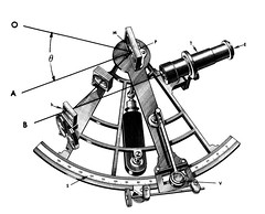
Longitude: what if the GPS satellite is out of commission?
GPS, the Global Positioning System, works well when all the satellites are functioning. There are many reasons why a satellite might be out of service, however. How do ships and airplanes find their longitude when the GPS is malfunctioning?
Sextant and chronometer.
A sextant, says Wikipedia.org, is an instrument generally used to measure the altitude of a celestial object above the horizon. Making this measurement is known as sighting the object, shooting the object, or taking a sight. The angle, and the time when it was measured, can be used to calculate a position line on a nautical or aeronautical chart. A common use of the sextant is to sight the sun at noon to find one's latitude.
A chronometer is a watch tested and certified to meet certain precision standards. The marine chronometer was invented by John Harrison in 1730. It enabled accurate marine navigation. For the next 250 years, an accurate chronometer was essential to any kind of marine or air navigation until the implementation of global satellite navigation at the end of the 20th century.
Wednesday, August 26, 2009
A suburb of London called Greenwich, England: Latitude, longitude and the globe
From WorldAtlas.com:
Latitude (shown as a horizontal line) is the angular distance, in degrees, minutes, and seconds of a point north or south of the Equator. Lines of latitude are often referred to as parallels.
Longitude (shown as a vertical line) is the angular distance, in degrees, minutes, and seconds, of a point east or west of the Prime (Greenwich) Meridian. Lines of longitude are often referred to as meridians.
Distance between Lines If you divide the circumference of the earth (approximately 25,000 miles) by 360 degrees, the distance on the earth's surface for each one degree of latitude or longitude is just over 69 miles, or 111 km. Note: As you move north or south of the equator, the distance between the lines of longitude gets shorter until they actually meet at the poles. At 45 degrees N or S of the equator, one degree of longitude is about 49 miles.
The Hydrologic cycle: condensation, precipitation, infiltration, runoff & evapotranspiration

John Fontaine dragging bayou debris, Shreveport Clean Up: Montessori / Anderson Island / Stoner Hill
Originally uploaded by trudeau
Oceans - 97.08%
Ice Sheets and Glaciers - 1.99%
Ground Water - 0.62%
Atmosphere - 0.29%
Lakes (Fresh) - 0.01%
Inland Seas and Salt Water Lakes - 0.005%
Soil Moisture - 0.004%
Rivers - 0.001%
Only during the ice ages are there noticeable differences in the location of water storage on the earth. During these cold cycles, there is less water stored in the oceans and more in ice sheets and glaciers.
It can take an individual molecule of water from a few days to thousands of years to complete the hydrologic cycle from ocean to atmosphere to land to ocean again as it can be trapped in ice for a long time.
For scientists, five main processes are included in the hydrologic cycle: 1) condensation,
2) precipitation,
3) infiltration,
4) runoff, and
5) evapotranspiration.
The continuous circulation of water in the ocean, in the atmosphere, and on the land is fundamental to the availability of water on the planet.
Tuesday, August 25, 2009
Rivers equal wealth
To understand the resources that can help make a region wealthy, look to resources such as oil and water. The future is going to bring much more emphasis on river systems as water sources. And with world population growing, the commodity called water is going to be more valuable.
Thus we see the importance of the Miss River valley has many components:
- water sources for cities and towns.
- water source for businesses - such as Pratt Industries recycing / paper plants.
- cheap transportation of goods such as ore, steel and garbage.
- recreation & tourism: cities such as New Orleans, Monroe and Little Rock all see their rivers as future sources of revenue through tourism and boating, biking and strolling.
Ramadan: across the globe, one billion people are fasting each day
Unbeknownst to you, many of your classmates are fasting from morning's first light to sunset. They are observing the Muslim month of Ramadan.
Ramadan, says Wikipedia: (also Ramazan, Ramzan, Ramadhan, Ramdan, Ramadaan) is the ninth month of the Islamic calendar. It is the Islamic month of fasting, in which participating Muslims refrain from eating, drinking, smoking, and indulging in anything that is in excess or ill-natured; from dawn until dusk [1]
Fasting is meant to teach the Muslim patience, modesty and spirituality. Ramaḍān is a time to fast for the sake of Allah, and to offer more prayer than usual. During Ramaḍān, Muslims ask forgiveness for past sins, pray for guidance and help in refraining from everyday evils, and try to purify themselves through self-restraint and good deeds.
As compared to solar calendar, the dates of Ramadan vary, moving forward about ten days each year. Ramadhan was the month in which the first verses of the Qur'an were revealed[Qur'an 2:185] to the Prophet Muhammad.
Latitude & Longitude: a review of the geography class basics
Using the textbook World Geography, Building a Global Prespective, we are reviewing the basics in classroom reading.
Here is a review that will guide you toward an effective overview.
1. A jet transport plane is likely to traverse a __ route as it goes on a transoceanic journey. a) Great Circle b) True Direction c) shipping d) Gulf stream.
2. The Mercator map is a cylindrical projection created about 1569 CE. T / F
3. Chinese greeting: a) Salaam alaykum b) Shalom
c) Ni hau d) S’up.
4. On the East the Mississippi River is adjacent to Louisiana, Mississippi, Tennessee and Minnesota. T / F
5. The Missouri River is longer than the Mississippi. T / F
6. What city lies at 39N, 116E?
a) Seoul, S. Korea b) Shanghai, China c) Beijing, China
d) Denver, Co
7. Greenwich, England, is home to the a) equator b) prime meridian c) prime rib, au jus.
8. Canada would be considered part of the __ hemisphere. a) Western b) Eastern c) Southern d) Central.
9. The Prime Meridian runs through London and the Equator runs through Hong Kong. T / F
10. The Tropic of Capricorn crosses South America, Africa, Madagascar and Australia. T / F
11. 90W is a line of longitude that runs through
a) Louisiana b) India and Bangladesh.
12. Latitude and longitude of Shreveport: a) 32N, 94E
b) 32E, 94N c) 32S, 94N d) 32N, 94W.
13. Pratt Industries is the company behind Shreveport’s new recycling program. Their main business is recycling a) paper b) wood c) plastics d) glass products.
14. Shreveport’s recycling company, Pratt Industries, has
built its center on a site advantageous for cheap transportation. It is located on ____. a) I-49 b) I-20 c) downtown d) Red River.
15. Henry Miller Shreve took on quite a project when he began - in 1832 - to clear the log jam from the Red River. Because of the obstruction called the Great Raft much of the water in this area had to find an alternate pathway. In East Shreveport that waterway was a) Cross lake b) Bayou Pierre c) 12 Mile Bayou d) Silver Lake.
Match a famous city with each of these coordinates:
16. 34N, 118W a) Boston b) Manila, Philippines c) Madrid, Spain d) Los Angeles
17. 19N, 99W a) Rio de Janeiro, Brazil b) Mecca, Saudi Arabia c) Mexico City
18. 22N, 115E a) Beijing, China b) Hong Kong, China c) Sydney, Australia
Supply the coordinates for -
19. Buenos Aires, Argentina a) 35N, 59E b) 35S, 59E c) 35S, 59W
20. Jakarta, Indonesia a) 6S, 106E b) 6N, 106E c) 6S, 106W d) 6E, 106S
Answers to be given in class.
Monday, August 24, 2009
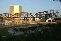
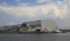
Pratt Industries paper recycling plant on the Red River allows city of Shreveport to offer curbside collection of recyclable materials
Pratt Industries has begun production at America's most modern and sophisticated lightweight containerboard mill in Shreveport, Louisiana.
The new, 100 percent recycled paper machine was specifically designed and engineered in Europe to make strong lightweight liners and mediums which can be used in a variety of end-use markets.
The Shreveport mill, our third paper machine in the United States, represents a $150 million investment in our industry's future, says the company web site. It will specialize in 23-pound liners and mediums to meet market demand for less packaging and greater environmental responsibility.
Every year the three Pratt paper mills combined will recycle more than 1 million tons of paper - preventing approximately 1.2 million tons of greenhouse gas emissions and saving 13 million trees.
The Shreveport site, which sits on Louisiana's Red River, is also home to our new Material Recovery Facility.
Recyclables, including paper, plastic and glass, are collected from city homes and processed for re-use. Pratt recycles the paper goods. It sells the glass, plastic and metal to other companies.
Maybe one day you will create a recycling facility. Either that or we'll end up like the people in the movie Wall-E.
Photo above from the New York harbor facility.
The culture of the Miss River valley: Raising Cane's Chicken Fingers
Raising Cane's Chicken Fingers is a fast-food restaurant chain founded in Baton Rouge, Louisiana by Todd Graves and Craig Silvey on August 26, 1996. The restaurant, says Wikipedia, offers fried chicken fingers as its only main course. Raising Cane's total revenue in 2007 was $97.3 million.
The initial concept for Raising Cane's comes from a concept developed by Graves for a business class project at LSU, for which he received a "C-".[1] Although the business plan was rejected numerous times by potential investors[citation needed], Graves and Silvey obtained a loan, which they used to open the first outlet in Baton Rouge at the intersection of Highland Road and East State Street near LSU. Originally competing against a similarly-themed drive-in called Bailey's Chicken Fingers on the opposite end of the campus, by 1999, Raising Cane's was able to prove itself the more successful business: it bought out Bailey's, becoming the only chicken-finger focused restaurant in the area.
In mid-1999, Silvey sold his stake to Graves to focus on completing an MBA at Wake Forest University and work in Silicon Valley. Later, Graves asked Silvey to return to Cane's as vice president of finance and information technology.
By 2006, the chain had grown to over 50 locations. Most of the locations are in Louisiana, particularly in the Baton Rouge area. The first location outside of Baton Rouge was opened in 2001 in Lafayette, Louisiana—since then, new stores have been opened in Mississippi, Texas, Colorado, Georgia, Ohio, Oklahoma, Nevada, Alabama, Virginia, Kentucky, Minnesota, and Nebraska, in addition to all eight metropolitan areas of Louisiana. Graves plans to continue expansion of his restaurant chain throughout the United States and internationally.
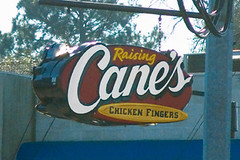
When a project or an essay is due via Google Docs . . .
When a project or an essay is due via Google Docs, you may have til 3:30 of that due date to hand it in On Time.
A small point penalty, approximately 10%, may be levied for late papers.
If there has been an important contingency that made you late, bring me a note signed by a parent to relieve the late penalty.
A small point penalty, approximately 10%, may be levied for late papers.
If there has been an important contingency that made you late, bring me a note signed by a parent to relieve the late penalty.
A slow-moving internet: the Mississippi River and tributaries
Review questions for quiz on Thurs -
1. Name the 5 states that lie west of the Miss.
2. Name the 5 states that lie east of the Miss.
3. The Mississippi R. is the second longest in the US. T / F
4. The state in which the Miss begins its course: __.
5. The Miss valley is connected to the Great lakes. T / F
6. The longest tributary on the east: __ __.
7. Longest tributary on the west: __ __.
8. Tributary that begins in Montana: __ __.
9. Which is more northerly, Memphis or St Louis?
10. Which tributary begins in the states of N Mex and Colorado?
See below for Miss Valley Map Project.
Thurs
a) Map quiz - hand sketched outlines of the states and 12 identifications (10 states, the Miss R and the Gulf of Mexico).
b) Open Notes quiz - 12 multiple choice questions on the notes thus far.
Friday, August 21, 2009
Preventing unwanted bleeding: the rubric for essay writing in geography class
A guide to my scoring for all your comparison essays:
1. Snappy title and explanatory subtitle: 2 pts.
2. Vivid and jazzy opening of paper: 2 pts.
3. Blending of the topics: 2 pts.
4. Use of comparison terms: 2 pts.
5. Specific details (she 3 dogs / she has dogs named Balthasar, Emmanuelle and Krishnamurti): 3 pts.
6. Grammar, spelling, construction: 3 pts.
Thursday, August 20, 2009
Choctaws: one of the Native American tribes that migrated to Louisiana
Among the items credited to the Choctaw:
a) the ward "bayou," which means "stream w slow-moving water."
b) knowledge of the regional herbs and roots that had healing powers.

a) the ward "bayou," which means "stream w slow-moving water."
b) knowledge of the regional herbs and roots that had healing powers.
Mr Mimal, mnemonics and map quizzes
From Minneapolis to New Orleans, a journey down of the Mississippi valley
In geography class the map quizzes begin with a blank page and a pencil. Students are expected to sketch the outline of the borders and write in the identifications. The outlines don't have to be precise. But they should be generally accurate and correctly demonstrate the relationships between regions and landmarks.
Next Thurs we'll have a map quiz on the 10 states surrounding the Miss R.
In committing these to memory, we will use 2 learning techniques:
a) Repetition. We shall do a map a day!
b) Mnemonics, or memory aids, shall be created. Mimal is a word created from the initials of the states on the west of the Miss.
Wiktm is the other fellow.
Barges on the Miss:
a) ore
b) bulk steel
c) garbage
Today we covered -
a) Blending the topics. Interlace your fingers to remember this one.
b) Comparison terminology, such as "similar to ..."
c) Generalities and Specifics. Such as Chinese-American food and General Tso's Chicken.
On Thurs, Aug 27 there will also be a multiple-choice, open notes quiz. Bring your print-out of web site notes. It's an Open Notes test.
The comparison essay is due Tues, Aug 25, via Google Docs.
Wednesday, August 19, 2009
Discriminating between the avocado that needs more time and the one that will be diced into a salad tonight
To discriminate does not mean to treat someone unfairly. The verb "discriminate" simply means to separate or to judge or to distinguish between.
If you can discriminate between a ripe avocado (a fruit that originated in the New World) and one that looks good but needs a few more days in the bin before it's usable, you'll be helpful in treks to the supermarket. The key item in your discrimination: when an avocado is ripe it is squishy.
Since we live in an age termed the Information Explosion, your job is to discriminate between helpful info and that which is not essential.
Therefore, you must edit your notes. You must decide which are the key words and which not. We will work on this skill in class. You will rise to higher levels of cogitation when you edit - abbreviate - your notes. And, yes, you'll be discriminating right and left.
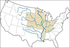
From Minnesota to the Gulf of Mexico: the Mississippi Valley in-class project
The Mississippi Valley project (5 pts) -
To be completed mostly in class, this review of the tributaries of the Miss. should have the following items:
1. 10 states - the ones that directly border the Miss.
2. The Miss. river.
3. The major tributaries -
Ohio R.
Tennessee R.
Missouri R.
Arkansas R.
Red R.
4. Add these cities:
Minneapolis-St Paul
St Louis
Memphis
Baton Rouge
New Orleans
5. Add a rim of color to the states. Save a contrasting color for the rivers.
6. Add titles (see guidelines).
The Mississippi River[2] is the second longest river in the United States, with a length of 2,340 miles (3,770 km)[3] from its source in Lake Itasca in Minnesota to its mouth in the Gulf of Mexico, says Wikipedia. The longest river, a Mississippi tributary, is the Missouri River measuring 2,540 miles (4,090 km)[4].
The Mississippi River is part of the Jefferson-Missouri-Mississippi river system, which is the largest river system in North America and among the largest in the world: by length (3,900 miles (6,300 km)), it is the fourth longest, and by its average discharge of 572,000 cu ft/s (16,200 m³/s), it is the tenth largest river.
The name Mississippi is derived from the Ojibwe word misi-ziibi ("Great River") or gichi-ziibi ("Big River") at its headwaters.
Wikipedia reminds us that "The Atchafalaya River in Louisiana is a major distributary of the Mississippi." What does that mean?
Thirsty issues in your future: water supplies and rivers
Rivers and lakes are going to loom in your future because water supplies will become strained by growing populations. At the moment, demographers tell us that Shreveport is losing population. But that could change.
Shreveport's water supply is Cross Lake. We're told that our water quality is rated as High.
Bossier City's water comes from the Red River. Many Bossierites have water filters on their faucets because the river water is more difficult to purify.
1. Louisiana river that originates in N Mex and flows through Tx and Ark: __ __.
2. "father of waters:" ___ __.
3. Flows into La from Ark: __ __.
4. La river that has the same name as a great river in Southern China: __ __.
5. In Choctaw the name of this river means "long river." It forms the Bayou State's largest swamp: __ __.
6. This river flows to the Gulf of Mexico on the western edge of La: __ __.
Monday, August 17, 2009
Parent signature to show awareness of Mondotrudeau; notes on Mon, Aug 17
So that parents are certain to be aware of the class web site I will give you 2 pts for having their signature in your notebook signifying that they know the address: http://mondotrudeau.blogspot.com. Deadline Friday.
Vocab:
a) Namaste': Hindi greeting used daily by almost 1 billion people in India. Demographers say that India's population will surpass that of China - some 1.3 billion - in the not-distant future.
b) Students will attend to their health when they stretch muscles and oxygenate the brain with yoga-based routines that originate in historic India.
c) Ni hau!: Over a billion people say hello each day with this Mandarin Chinese greeting.
Demographics: the study of populations.
Ex: examining trends in the Magnet population by polling the middle schools represented. My conclusion is that Magnet's mix of middle schools helps everyone become friendly. Almost everyone needs new friends at Cmhs.
Why do bookstores avoid ordering large numbers of books? The business model called Just In Time keeps the expense of inventory low and efficient shipping methods keeps customers reasonably happy.
Assignment: Your first writing will be a comparison essay that is a brief profile of 2 of your classmates. I'll be using the web site notes to prepare you to write the piece.
Deadline: Tues, Aug 25.
It will be submitted via Google Docs. See instructions here.
Monday:
1. Monday is related to
a) the cruel ancient Canaanite god called Moloch.
b) the "money spider"
c) a German word associated with the moon.
Answer: "Moon day."
In Ray Bradbury's book, Fahrenheit 451, the hero's name is Montag, which means Monday or Moon day.
Sunday, August 16, 2009
The value in geography class is not in the facts
Facts can always be referenced via Answers.com, Wikipedia, World Book, the CIA.gov site and many other sources.
The value in a high school social studies class is in the patterns you develop -
- punctuality.
- manners.
- locution / clarity in wording your questions and answers.
- beginning work each day without having to be told what to do.
- having the tools for the job on a consistent basis - the atlas, notebook, pens, colors, scissors, chewing gum (just kidding).
- knowing what can be found in the atlas, the textbook, the encyclopedia, thesaurus, etc.
- questioning.
- listening.
- spacing and appropriately annotating and illustrating your notes.
- mnemonics and visual learning aids.
- understanding the value of practice and repetition.
- having what author Ernest Hemingway called a "built in, shock proof crap detector." Also known as a sense of evaluation.
- sense of humor that fits the situation.
- understanding that school is a game. Play the game with a sharp sense of the rules and you can win without too much strain.
- jazz your projects with a snappy title.
- open your writing with colorful description, or a quote. Avoid boring your teacher or your classmates.
- don't study one topic when you can bring in a second topic and compare the two (fencing? Let's compare fencing to pottery, OK?).
- "according to ...": document your writing and your pronouncements with the phrase "according to the NY Times...".
- use quotes ("Frankly, my dear, I don't give a damn," is not what I'm talking about. Or is it?).
- be specific (today the price of a bbl of crude hit $116, said NPR).
- offer an example (such as the role of Niha Jain's special programs for students in winning admission to Yale).
- look for connections between topics, whether they are conflicts (compare the US occupation of Iraq to our role in the Vietnam conflict) or resources (compare Thomas Edison to Page & Brin, the fellows who founded Google).
- use varied media: video, powerpoint with voice-over, paper sculpture, the ouija board.
- use color in all study-related work.
- look it up - as we do in class as I quickly reference wikipedia on topics of our discussion.
- keep a record of all your work and as many scores as possible.
- find a middle ground between *sucking up to your teachers* and making a good use of the aid that is available from teachers.
- use your classmates' skills and generosity appropriately.
- don't be shy about asking for help when you are *not getting it.*
- ask questions of your classmates (when class allows such activity), whether formal ("Might I borrow thy eraser?") or informal (Great shoes. Where'd you get them?").
- compliment everyone ("You have the best smile!" or "Great shirt!" or "Your quiet intensity is so cool."). And follow it up with a question or two - about that other person.
An overview of Trudeau's world geography class in the curriculum

Geography is a social studies regimen in which students take a humanities approach appropriate to a college-oriented high school curriculum. The class integrates
* study of language (especially Greek and Latin roots)
* literature (often through classic films such as Gandhi)
* architecture (students make abbreviated models of buildings such as the Taj Mahal and the Great Mosque at Mecca)
* cuisine (taste this Japanese nori, or cultivated seaweed, and write down 5 sensory words)
* music (ethnic or classical music is played in the classroom daily)
* map study (students can draw and label a map comprising the entire world by year's end), * economy (per capita income, standard of living) and
* history (kings & queens, empires, wars).
Subject-matter units may vary in order and substitutions may occur according to world conditions.
Skills emphasized in geography class comprise the higher thinking modes: analysis, synthesis, evaluation, composition and questioning. The primary theme is that students are encouraged to gather information about a nation / culture and compare it to previously-studied nations. Quizzes focus primarily on reading and organizational skills. Reading comprehension is a key to this class as well as to your future success in school and work.
Analysis: to take apart the elements of a culture:
* land - ex., from the cold Himalayas to bustling Shanghai
* resources - petroleum, alumina, arable land, work ethic
* history - golden eras, wars, colonialization, empire
* arts - architecture, painting, sculpture, literature, clothing
* philosophy - What is the theme of Confucianism? can you identify the difference between Buddhism and Taoism?
* government - authoritarian, socialist, democratic
* economy - free enterprise, government controlled, modified
* ethnic groups - Mongolian, Chinese, Japanese, Korean, Creole
* language - Latin, Greek, Sanskrit, Hindi, Mandarin Chinese
* religions - the degrees of fervor in Christian, jewish and Muslim communities
Synthesis: combine elements of cultures to offer a theme or thesis.
Ex., a) Write a brief essay showing the similarities in Chinese and American cultures. b) Create an annotated map that shows the influence of Buddhism across several nations in Asia.
Questions which accompany each class activity emphasize interpretation and comparison.
Ex.: if most of the world's poor population cooks over charcoal, what are the indirect stresses on the environment? answer: not only air pollution, but deforestation (charcoal being the product of partially burned trees). Deforestation leads to excessive erosion of topsoil and to an extreme danger: a decline in agricultural production.
Learning styles exploration and communication styles evaluation are the subtext for this social studies class.
* How effective is repetition? How can repetition be made bearable?
* How does art - ex., illustrations - enhance learning? Does color add significant impact to communication?
* Does a hands-on activity (for instance, a puzzle map) enhance retention of material?
* Does a multiple-choice quiz create involvement in a general audience? Is multiple-choice more appealing than a fill-in-the-blanks quiz? Why?
If students both see material on the board, write it down, add an illustration, add color, create a quiz and write an essay on the material do we reach a high level of understanding and retention? That is this teacher's idea of a thorough lesson.
Composition engages students in the highest mode of thinking.
Written communication must be
orderly; logic and chronology and thoughtful transitions must be in evidence. Writing must be:
* detailed - examples and documentation make a full-bodied article.
* lively - a snappy title and colorful opening are mandatory.
* credible - "according to" and a source must accompany all fact and even presentations of opinion. Meanwhile, we also avoid plagiarism.
* insightful rather than lengthy - while offering an adequate amount of evidence is important, the highest level of writing demonstrates questioning, offers a thesis and demonstrates leaps of imagination.
Materials
Rand McNally Quick Reference World Atlas is used in class virtually every day and on every quiz. It comprises demography, topography, political life, and spatial relationships. The RMQRWA offers students opportunities for exploration, memorization and global insight.
Handouts, lectures, visual presentations and activities developed by your teacher from material in the NY Times, Public Broadcasting, National Geographic, World Book and numerous additional sources.
The Class Web Site at http://mondotrudeau.blogspot.com is designed to help create a partnership in learning between student, teacher and parents. Assignments, activities, notes, announcements and tests are updated at least weekly on the web site. Here you will find opportunities for bonus credit writing assignments and a place to catch up on notes and tests when you are ill or otherwise absent.
Guest speakers and field trips offer a first-hand learning opportunity. Students' questions are highly valued during these experiences. Post-activity essays afford us an opportunity to evaluate the experience.
Evaluation
Memorization is exercised by a regular schedule of map tests. Spelling counts, as it does all one's life.
Open Notes Multiple Choice Tests offer a challenge to students' ability to take accurate notes, to organize their notes and to use pertinent resources, such as notes from the class web site and resource books in the classroom. Also measured by Open Notes Tests is the ability to read questions and the ability to use deduction in choosing answers.
Essays
Student growth in communications and thinking skills are challenged in the most stringent way by essay questions. Students are given evidence in handouts and expected to follow essay guidelines.
Projects
Special teamwork assignments such as making Powerpoint presentations are an important part of a varied academic diet.
Independent work
Essays are the primarily recommended form of independent work. Each week I suggest several topics for research and writing. From time to time I may allow students to bring a taste of a foreign cuisine to school. I also encourage audio-visual projects such as video and other photography projects.
Email is my way of extending my care to the students I teach each day.
Parents and students' questions are welcome via email. Please sue trudeau@earthlink.net.
Benchmarks
Instruction and student achievement will be based on these items, as mandated by the Department of Education:
Solving geographic problems by use of geographic materials.
Organizing material by formulating mental maps.
Determining how location and social, cultural, and economic processes affect the features and significance of regions.
Analyzing the structure and interconnectedness of regions.
Determining the social factors that impact human systems.
Analyzing demographic materials.
Comparing economic systems.
Examining the role of technology in human achievement.
Describing the earth's physical challenges and searching for solutions.
Using concepts such as chronology and conflict to analyze history.
Interpreting primary and secondary sources.
Conducting research in efforts to analyze historic issues.
Analyzing cause and effect relationships.
Analyzing and demonstrating an understanding of nations' changes in the modern era.
Analyzing the origins, central ideas and impact of great religions and philosophies.
Tracing the interconnectedness of peoples through research into national and cultural forces.
Grade level Expectations
Competent use of all sections of the atlas.
Mental mapping.
Comparison of cultures.
Use of graphs and diagrams in communicating geographic material.
Drawing conclusions about locations based on the evidence in maps and graphs.
Analysis of economic forces.
Demonstrate an understanding of demographics.
Inquire into the forces that create war and peace.
Describe the cultural forces that link the world's regions.
**
Your questions and input are valued in World Geography at CMHS
Schedule, Robert Trudeau:
1. World geography, 8:30 - 9:30
2. Fine Arts Survey, 9:35 - 10:35
3. World geography, 10:40 - 11:50
4. planning / duty, 11:50 - 1:20
5. World geography, 1:25 - 2:25
6. World geography, 2:30 - 3:30
Classes 1 through 4 are adjusted on Weds when we have Activity Period, which is for club meetings and independent class work.
Activity Period is 10:20 - 10:45.
Sponsorships -
1. Freshman class; meetings called as needed.
2. Leadbelly Society, an arts club which meets each activity period.
3. Picasso Digital Arts, a photography/video club which meets after school.
Email is my way of extending my care to the students I teach each day.
Parents and students' questions - do not hesitate - are answered efficiently by the use of email. Please use trudeau@earthlink.net.
In an emergency or to return my call, you may ring my cell: 272 6045.
You may also leave a message for me at the Magnet office: 221 2501.
Personal computer classroom policy
While the class will frequently visit the computer lab and library, I see value in independent use of personal computers in the classroom.
Personal computers are a difficult item at school. While some students have the discipline to stay on task, it is tantalizingly easy to slip away from the instructional activities. It's my goal to help students integrate the personal unit into class in a productive mode. To do that I have to be able to monitor student use. Sadly, if I cannot easily see the screen then I must ask the student to forego use of the unit.
Acceptable use -
* Taking typed notes.
* Researching definitions of geo class terms.
* Googling items discussed in class for additional background and the latest news.
Non-acceptable use -
* visiting sites other than those germane to the work above.
* recording audio or video of classroom activities unless permission is requested and granted - on a per-activity basis.
* students will not be allowed to use personal units on Open Notes Quizzes.
Accountability -
* I will check each student's screen on a regular basis. Students will at all times orient toward the teacher so that I can quickly review it.
* I will ask all students for a closer look at their screen on a random basis.
* Finding a student on a non-relevant site will result in a one-week hiatus from using the unit in class.
* Repeated violations of the policy will result in a long-term ban on classroom use.
Typical Open Notes quiz: Obama biography
Barack Hussein Obama: based on the wikipedia.org bio of the president.
1. Barack Obama's father was a native of the nation of a) Tanzania b) Kansas c) Kuwait d) Kenya.
2. Obama did his undergraduate work at Columbia University, which is in a) NYC b) Boston c) Honolulu d) Philadelphia.
3. Both he and Michelle graduated from Harvard Law, which is in a) NYC b) Boston c) Honolulu d) Philadelphia.
4. In addition to politics, he has been a teacher of constitutional law at the Univ of a) Illinois b) Chicago c) Indiana d) Washington.
5. He spent 14 years of his childhood in Indonesia. T / F
6. Obama used alcohol, marijuana, and cocaine during his years as a community organizer. T / F
7. Obama has been both a US Representative and US Senator from greater Chicago. T / F
8. He is the successful author of a book called a) Dreams From My Father b) A Tale of Two Cities c) Invisible Man d) Gone with the Wind.
9. The name Hussein indicates a Muslim influence in his family. That would come from a) Kenya b) Indonesia c) Hawaii.
With his black Kenyan father and white American mother, his upbringing in Honolulu and Jakarta, and his Ivy League education, Obama's early life experiences differ markedly from those of African-American politicians who launched their careers in the 1960s through participation in the civil rights movement.[204] Expressing puzzlement over questions about whether he is "black enough", Obama told an August 2007 meeting of the National Association of Black Journalists that the debate is not about his physical appearance or his record on issues of concern to black voters. Obama said that "we're still locked in this notion that if you appeal to white folks then there must be something wrong."
Based on the paragraph above:
10. Obama’s background represents the history and the struggle of the civil rights
movement in America. T / F
11. Obama’s appeal to voters of all ethnic groups has been a source of puzzlement to many Americans. T / F
Geography class homework: reading the notes posted daily at Mondotrudeau so as to be prepared for Open Notes Quizzes
Tests on class activities, class notes and readings will be based on the notes posted on MondoTrudeau. Thus I expect each student to read the class web site daily.
Students will not be issued a copy of the textbook World Geography. It will be used in the classroom on a regular but not daily basis.
The typical test in geography class will be an Open Notes Quiz. In a change from last year's procedures, I will require that all students use only printed or written notes. Personal web browsers will not be allowed.
The idea is to prepare your information management skills in such a way that your success in school (and beyond) will be assured.
Reading notes on MondoTrudeau will, most days, be your only homework. Scanning the notes is something like reading a textbook. Read them and then print them and put them in a folder or binder. You may cut and paste when you feel it will save paper and ink.
One of the key developmental activities this year is growth in reading comprehension. The typical test in geography includes questions designed to test the accuracy of your reading. Some questions will test your ability to interpret the notes. Test questions will be based on the multiple choice format.
Scrumptious to bizarre: Comparison essay guidelines
The elements that will guide essay writing in geo class includes:
1. Colorful opening. There are 3 recommended ways to create an interest-getting opening: a) use a quote b) ask a question c) write with vivid description.
2. Blend the topics continually in the paper. Do not write a block of material about one topic and then write a separate block about the other topic. Integrate the topics as you offer insight and evidence.
3) Use comparison terms:
* different from,
* the same,
* Both,
* similar to,
* Neither, ... nor,
* like X is (adjective),
* ... than X is (adverb) than.
* both, ...
* either...or
* likewise
* similarly
* although,
* but neither...
* nor
* however
* on the other hand
4. Specific examples must be used to support generalities. An example:
generality - "'The Incredibles' was an awesome movie. Loved it."
specific - "'The Incredibles' appealed to me because the characters, especially the mom and the teen sister, were believable. They sounded like people I know."
5. Grammar counts.
6. Spelling, too, counts. When in doubt, see a dictionary or ask me.
7. Punctuation is paramount. Again, ask me or consult your English class guide.
8. Include documentation via "according to ...". This means include your source - from World Book to your little brother - in the body of your writing. Usually you place it at the end of the first or second sentence, says Grammar For Today.
9. Write a snappy title and an explanatory subtitle. Ways to make a title fun are to tweak a song or movie title or use alliteration.
Example: Dinkas are Incredibles; Many refugees from the Sudanese Dinka tribe have moved from poverty in east Africa to comfort in the US.
10. Finally, please don't put quotation marks around your title - unless you are quoting someone.
Thursday, August 13, 2009
Establishing a gmail.com account for submitting papers and projects in world geography class
** Please establish a gmail.com account that is identified by your first and last name. Using periods between names is a good way to make your address unique.
ex: sarah.j.williams@gmail.com.
By that standard, my account is not done correctly. Instead of trudeau11@gmail.com I should have asked for robert.trudeau@gmail.com. But for the moment I'm staying with trudeau11@gmail.com.
This is the account that will allow you to submit papers to your teacher via GoogleDocs. Your collection of papers and projects at GoogleDocs will become, in effect, your digital portfolio.
- Your first GoogleDoc for this class will be labeled "Background" (but do Not use the quotation marks that I used).
. Please list parents’ or guardians’ names, address and cell phone numbers for both parents/guardians.
. Also list schools attended and the schools' locations.
. You may list honors won in school and outside of school.
. Please add your hobbies.
. Also: books read this summer.
. It's helpful to me if you will also add your parents' occupations and work locations.
World geography / Robert Trudeau / materials 09 - 10
Caddo Magnet High School / World Geography
Robert Trudeau / trudeau@earthlink.net / CMHS: 221-2501
Welcome to Robert Trudeau's World Geography at CMHS
** Required atlas: Rand McNally Quick Reference World Atlas ($6)
Easy to carry (bring it to class every day); inexpensive. Please do not substitute. Available at Barnes & Noble, other stores and also - cheaply and quickly - at Amazon.com.
** Fee: $5, payable to Caddo Magnet High School. Defrays cost of field trips and special materials. Bookkeeping procedures prohibit parents from writing one check to cover their students' several fees. Sorry!
** Scissors (small), colors (map pencils, crayons or pastel markers)
** Notebook must feature a) pages with perforated edges b) pockets for handouts.
At Mondotrudeau you will find class requirements, assignments, reviews and links to more detailed reading.
* Plan your week by viewing mondotrudeau each Sunday afternoon. You will see an outline of the week’s activities.
* Thursdays are the day for essays, tests and project deadlines.
Geography class syllabus / unit schedule 09 - 10
As guided by the comprehensive curriculum, which insures topical uniformity across the parish . . .
Aug: basic skills in geography (2 weeks)
Sept: US & Canada (4)
Oct: Central & South America & the Caribbean (3) also, Europe begins.
Nov: Europe (4)
Dec: Russia & Northern Eurasia (3)
Jan: Middle East (SW Asia) & Mediterranean Africa
Feb: Sub-Saharan Africa (3)
April: East Asia (3)
May: Australia & Oceania
Caddo Schools' calendar for 09-10
August 17 (Monday) All Students Report /1st Reporting Period Begins
September 7 (Monday) Labor Day (Schools Closed)
October 15 (Thursday) 1st Reporting Period Ends (43 Days)
October 16 (Friday) Fall Break (Schools Closed)
October 19 (Monday) 2nd Reporting Period Begins
October 19-23 GEE Retest Days
November 23–27 Thanksgiving Holiday (Schools Closed)
December 21 - January 1 Christmas Holiday (Schools Closed)
See more at http://www.caddo.k12.la.us/
January 8 (Friday) 2nd Reporting Ends (45 days)
January 11 (Monday) 3rd Reporting Period Begins
January 15 (Friday) Professional Development Day (Schools Closed)
January 18 (Monday) Martin Luther King Jr. Holiday (Schools Closed)
February 8-12 GEE Retest Days
February 15 Presidents’ Day Holiday (Schools Closed)
March 12 3rd Reporting Period Ends (42 Days)
March 15-19 Spring Break (Schools Closed)
March 22 (Monday) 4th Reporting Period Begins
April 2 Good Friday Holiday (Schools Closed)
April 12-16 LEAP/iLEAP Test Days
May 11-13 Senior Final Exams
May 13 Last Day for Seniors
May 27 4th Reporting Period Ends (48 Days) Last Day for Students
May 28 (Friday) Teacher Work Day
May 18-24 or May 21-23 Senior Graduations
Student Days, 178, Teacher Days, 182
LSUS Animation & Visual Effects open house Mon, Aug 17, 6 pm
Highly recommended for Magnet students and families!
Subscribe to:
Posts (Atom)
