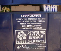
While the program is limited to paper products, Magnet recycling has begun again. The re-start is courtesy of a weekly pick-up and dumpster-type bin supplied by Pratt Industries.
"Please break down any cardboard boxes or other bulky containers," begs custodian Mrs. J. Wright. "We will run out of space if we don't fold the boxes."
Newspapers, magazines, catalogs, school paper, junk mail, cardboard and even books are acceptable recyclables.
Please, no plastics, metals, glass or garbage.
Once a week pickup is on Tues evening.
Wednesday, September 29, 2010
Another way to earn Indie points: an essay on a visit to Sciport's Imax Theater
Another way to earn Indie points: an essay on a visit to Sciport's Imax Theater.
The current movie on Greece is one that I've seen and recommend.
Your essay on the movie need not be long but must have
- a jazzy title,
- snappy opening,
- details,
- documentation and
- 2 quotes.
Btw, here's the latest: you can now enjoy Counter Culture food in Sciport.
Send it to trudeau11@gmail.com.
Tuesday, September 28, 2010
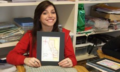
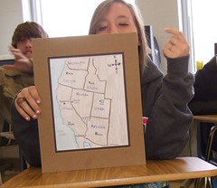
The California Map Project - test your peers and family
Evaluating your ability to teach the landmarks of California -
- Make 5 copies of the map of California on 5 pages in your notebook.
- Add 12 lines to the map in the places where you expect your pupil to add identifications.
- Place a word bank on the side of the page.
Then
a) Let them take a pre-test. How much do they know about the map without review?
b) Use your atlas to bring them up to speed on the landmarks.
c) Let them have another shot at filling in the blanks.
d) Score them.
e) Get their signature and their brief profile (ex: father of 3, age 45, minister).
15 pts. Due in the last class of next week.
4 neighbors
ocean
4 cities
bay
mountains
desert
valley
high tech region
Indie work: integrating the bios of Leo Fender and Ruth Handler
Two giant developers from Los Angeles: the late Leo Fender and Ruth Handler.
Comparison essay
- Fun title
- Zappy opening sentence
- Blend the topics.
- Document.
- Details!
- Send to trudeau11@gmail.com
Comparison essay
- Fun title
- Zappy opening sentence
- Blend the topics.
- Document.
- Details!
- Send to trudeau11@gmail.com
John Muir, father of the national parks and Sierra Club
John Muir (1838 – 1914) was one of the earliest mountain men of California.
He was a Scottish-born American naturalist, says Wikipedia, an author, and early advocate of preservation of wilderness in the United States.
His letters, essays, and books telling of his adventures in nature, especially in the Sierra Nevada mountains of California, have been read by millions.
His activism helped to save the Yosemite Valley, Sequoia National Park and other wilderness areas. The Sierra Club, which he founded, is now one of the most important conservation organizations in the United States.
Our mission: Be responsible, respectful and seek excellence
The Magnet mission that unites our energies each day:
a) Be responsible.
b) Be respectful.
c) Seek excellence.
a) Be responsible.
b) Be respectful.
c) Seek excellence.
Sunday, September 26, 2010
Tectonica: last week's quiz and the source of the answers
The multiple-choice, open notes quiz Tectonica was designed to be answered using the print-out of recent notes and the by re-reading material that we'd reviewed in the textbook while doing the Tectonics Graphics Project.
1. The adversary system is one in which governmental groups aid each other in getting their tasks completed. T / F
2. A person who is friendly and has a lot in common with you may be described as __ . a) patriarchal b) sympatico c) onomatopoeic d) muy bonita.
3. Pratt Industries is an awesome company that operates paper mills and recycling plants. Additionally, it manufactures commodities including "lighting, electronics, glass and communications." T / F
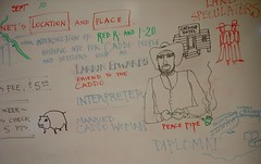
4. Tarshar, chief of the Caddo, had an ally (friend and supporter) in the 1835 negotiations with the US government. He was a) Larkin Edwards b) William B Stoner c) Henry Miller Shreve d) John Coates.
5. Watching the tracking info that shows the shipment of an Apple computer as it journeys on ship from Shanghai, China, to the port of Los Angeles. a) Ring of Fire b) subduction c) faulting d) spreading.
6. The mid-Atlantic ridge: a) converging b) subduction c) faulting d) spreading.
7. What is happening on the Western side of South America where the Nazca Plate is meeting the South American Plate: a) converging b) subduction c) faulting d) spreading.
8. These places are considered desirable despite the threat of earthquakes and volcanoes: Southern California, Japan and a European nation: a) England b) Italy c) Spain d) France.
9. What kind of crust might include anchovies (fish preserved in brine)? a) oceanic crust b) continental crust c) subductional crust d) Arabian crust.
10. Iron mixed with nickel: a) core b) crust c) mantle d) nucleus.
11. Includes solid and pliable material as well as magma. a) core b) crust c) mantle d) nucleus.
12. Similar in direction of movement to the Indo-Australian Plate: a) Eurasian plate b) African Plate c) Arabian Plate d) South American Plate.
13. The earth's plates move because of force generated by : a) subduction b) convection c) faulting d) spreading.
14. The textbook says, in effect, that human population is growing fastest around the Pacific Plate. T / F
15. The Tectonic Plate Boundaries Map, p. 43, demonstrates that earthquake zones are more common in the Northern Hemisphere as well as in the Western Hemisphere. T / F
16. The length of the San Andreas Fault is approximately a) 350 b) 550 c) 750 d) 1,150 miles.
1. False. See WG (World Geography, a Global Prespective); an adversary is your opponent.
2. Sympatico. Class notes; MT (MondoTrudeau).
3. False. MT. And logic.
4. Larkin Edwards. MT.
5. Ring of Fire=the Pacific rim. None of the tectonic terms made sense.
6. Spreading. WG.
7. Subduction. WG.
8. Italy. WG.
9. Oceanic crust. For fun.
10. Core. WG.
11. Mantle. WG.
12. Arabian Plate. WG.
13. Convection. WG.
14. True. WG and MT.
15. False. Northern and Eastern Hemisphere. WG.
16. 750 miles. WG and MT.
1. The adversary system is one in which governmental groups aid each other in getting their tasks completed. T / F
2. A person who is friendly and has a lot in common with you may be described as __ . a) patriarchal b) sympatico c) onomatopoeic d) muy bonita.
3. Pratt Industries is an awesome company that operates paper mills and recycling plants. Additionally, it manufactures commodities including "lighting, electronics, glass and communications." T / F
4. Tarshar, chief of the Caddo, had an ally (friend and supporter) in the 1835 negotiations with the US government. He was a) Larkin Edwards b) William B Stoner c) Henry Miller Shreve d) John Coates.
5. Watching the tracking info that shows the shipment of an Apple computer as it journeys on ship from Shanghai, China, to the port of Los Angeles. a) Ring of Fire b) subduction c) faulting d) spreading.
6. The mid-Atlantic ridge: a) converging b) subduction c) faulting d) spreading.
7. What is happening on the Western side of South America where the Nazca Plate is meeting the South American Plate: a) converging b) subduction c) faulting d) spreading.
8. These places are considered desirable despite the threat of earthquakes and volcanoes: Southern California, Japan and a European nation: a) England b) Italy c) Spain d) France.
9. What kind of crust might include anchovies (fish preserved in brine)? a) oceanic crust b) continental crust c) subductional crust d) Arabian crust.
10. Iron mixed with nickel: a) core b) crust c) mantle d) nucleus.
11. Includes solid and pliable material as well as magma. a) core b) crust c) mantle d) nucleus.
12. Similar in direction of movement to the Indo-Australian Plate: a) Eurasian plate b) African Plate c) Arabian Plate d) South American Plate.
13. The earth's plates move because of force generated by : a) subduction b) convection c) faulting d) spreading.
14. The textbook says, in effect, that human population is growing fastest around the Pacific Plate. T / F
15. The Tectonic Plate Boundaries Map, p. 43, demonstrates that earthquake zones are more common in the Northern Hemisphere as well as in the Western Hemisphere. T / F
16. The length of the San Andreas Fault is approximately a) 350 b) 550 c) 750 d) 1,150 miles.
1. False. See WG (World Geography, a Global Prespective); an adversary is your opponent.
2. Sympatico. Class notes; MT (MondoTrudeau).
3. False. MT. And logic.
4. Larkin Edwards. MT.
5. Ring of Fire=the Pacific rim. None of the tectonic terms made sense.
6. Spreading. WG.
7. Subduction. WG.
8. Italy. WG.
9. Oceanic crust. For fun.
10. Core. WG.
11. Mantle. WG.
12. Arabian Plate. WG.
13. Convection. WG.
14. True. WG and MT.
15. False. Northern and Eastern Hemisphere. WG.
16. 750 miles. WG and MT.
California Dreamin: songs about the Golden State
For discussion and listening: a selected list of tunes that your teacher considers classics about California.
- All I Wanno Do / Sheryl Crow
- Blue Jay Way / Beatles
- Born in East L.A. / Cheech & Chong
- California Dreamin' / Mamas & Papas
- California Girls / Beach Boys
- Do You Know the Way to San José / Dionne Warwick
- Folsom Prison Blues / Johnny Cash
- For What It's Worth / Buffalo Springfield
- Free Fallin' / Tom Petty
- Going Back to Cali / LL Cool J
- Hotel California / the Eagles
- I Left My Heart in San Francisco / Tony Bennett
- Hooray for Hollywood / Johnny Mercer
- I Love L.A. / Randy Newman
- Midnight Train to Georgia / G;adys Knight & the Pips
- San Francisco (Be Sure to Wear Flowers in Your Hair) / Scott McKenzie
- (Sittin' On) The Dock of the Bay / Otis Redding
- Under the Bridge / Red Hot Chili Peppers
Topics in the California Project
Each student must have 3 slides. Or 3 art pages, well sketched and colored.
Each image must include 3 bulleted items: brief notes - edited to 4 to 6 words - on the most important facts on that image.
Due Th/Fri. Place in email to yourself or on flashdrive.
9 pts.
Topics
1. Sierra Nevada range
2. Lake Tahoe
3. Yosemite Valley
4. Giant Sequoia / Redwoods
5. The Central Valley, aka The Valley
6. San Francisco Bay
7. Mojave Desert
8. Death Valley
9. San Diego
10. Los Angeles history
11. Los Angeles demographics / ethnic diversity
12. Los Angeles landmarks
13. Los Angeles economy
14. San Francisco history
15. San Francisco landmarks
16. Silicon Valley
17. Stanford University
18. Univ of Cal at Berkeley
19. Sacramento
20. San Andreas Fault
21. California ethnic demographics
22. California agriculture
23. Golden Gate Bridge
24. Colorado River
25. Mediterranean climate
26. Big Sur region
27. California State Route 1, aka the Coast Highway
28. Santa Barbara
29. Orange County
30. Marin County
31. Venice, Los Angeles
32. Hollywood
33. UCLA
34. Los Angeles / Long Beach Harbor
Friday, September 24, 2010
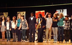
A Walk in the Garden: Talent Show on Fri, Sept 24, 6:30 to 8:30 pm, PAC
A Walk in the Garden: Talent Show on Fri, Sept 24, 6:30 to 8:30 pm, PAC.
Tickets $5 and may be purchased at the door.
Please plan to pick up no later than 8:30 pm. Better yet, parents should themselves enjoy the talent. It will be terrific entertainment, I can assure you.
Tickets $5 and may be purchased at the door.
Please plan to pick up no later than 8:30 pm. Better yet, parents should themselves enjoy the talent. It will be terrific entertainment, I can assure you.
Wednesday, September 22, 2010
Getting to know the Pacific rim: California quiz
California & Silicon Valley
1) Napa Valley is associated with the art and science of making wine - something at which California excels. Wine-making is called a) vino
b) vineyard c) viticulture d) vintners .
2) Birth of the Fender Telecaster and Precision bass: a) Los Angeles
b) Sacramento c) Palo Alto d) San Diego.
3) Founded by a duo; functions as a triumvirate: a) Google b) Microsoft c) Apple d) US government.
4) Position of the island called Alcatraz relative to the Golden Gate:
a) East b) West c) North c) South.
5) With Stanford University, Google and UC Berkeley in the region, the main industry of Silicon Valley is higher education. T / F
6) Pacific Rim location is an advantage for the Port of Los Angeles because cargo can come directly from __ to the US. a) India b) Britain
c) Brazil d) China.
7) Affluent area: a) San Francisco b) Anaheim c) Oakland d) Malibu.
8) “We live in a litigious society.” In other words, a society that is
a) entrepreneurial b) prone to spraining ligaments c) suit prone
d) communications-minded.
9) Stanford students Sergey Brin and Larry Page collaborated on the creation of a) Yahoo b) Google c) Apple d) the Bill & Melinda Gates Foundation.
10) Los Angeles is found at about 34N latitude, 118W longitude. If you had a gigantic tunnel-machine capable of drilling through the core of the earth, you could start at LA and come out, on the other side of the globe, near Beijing. T / F
11) T / F Vietnam and Tibet border China.
12) Cheap labor and highly-educated workers are abundant in the nations of China and __. a) South Korea b) Somalia c) Britain.
13) The area to be known as Silicon Valley was initiated into the high tech world by a) the Navy Research center b) NASA’s aeronautics research c) a venture capital arrangement by a Stanford professor.
14) Not a part of Silicon Valley: a) Mountain View b) Cupertino c) Palo Alto d) Oakland.
15) The Pirates of the Caribbean movies made extensive use of computer-generated images (CGI). Based on our recent studies, we can assume much of the work for those movies was done in a) San Francisco b) Los Angeles c) San Diego d) New Orleans.
16) Hewlett-Packard, an early American high tech company, was founded in a) 1939 b) 1959 c) 1979.
17) In the 1970s and 1980s, ____'s Palo Alto Research Center (PARC) played a pivotal role in object-oriented programming, graphical user interfaces (GUIs), Ethernet, PostScript, and laser printers.
a) Apple b) IBM c) Xerox d) Microsoft.
18) The Sierra Nevada mountains are part of the Rocky Mountains. T / F
19) In California’s southeasternmost region is a large empty quarter. No mountains, no municipalities. That area must be a) the Mojave b) Death Valley c) Nevada d) San Joaquin Valley.
20) According to the Silicon Valley article in Wikipedia.org, the following organizations are headquartered there: eBay, Dreamworks Animation & TiVo. T / F
The glories of the Golden State, California
Notes on California/Los Angeles/San Andreas fault
Cal: 37M
3rd largest US, pop & area
GDP: 1.5 trillion (Gross Domestic Product, a measurement of a nation';s wealth)
13% of US econ
area larger than Germany
Ag: the Central Valley (which is partly desert)
Sierra Nevada (snowy mtns)
Mt Whitney - highest peak in cont. US
Yosemite Natl Park (Ansel Adams)
Lake Tahoe (tourism)
Over 1/3 state is forested!
megalopolis: when several cities “grow together”
1) SanJose-SanFrancisco-Oakland
2)LA-LongBeach-SantaAna-Irvine-Anaheim-SanBernadino
pop: 12.9 M
Most pop state 12% of Amers
More Cals than Canadians
One of 3 minority-majority states (others: Hawaii, N Mex)
Spt a minority-majority city:
51% black, 46% white, 2% Asian
(US African-Amer pop 13%)
industry
1) ag 2) aerospace 3) entertainment / tv 4) mfg 5) mining
6) digital services
largest US port: LA / LB
prof sports a major economic force
San Andreas fault:
800 m / SCal
right-lateral strike-slip fault / geological term
ready for the “next big one”
devastation LA to San Diego
Diverse state:
largest Asian-Am in US
140 countries rep in LA
polyglot - many languages
eucalyptus project, California redwoods / n of Marin county.
Note-taking skills: space, brevity, legibility
**********************************
California quiz answers
1. c) viticulture
2. d) Fullerton
3. a) Google
4. a) East
5. F
6. d) China
7. d) Malibu
8. c) suit prone
9. b) Google
10. T
11. F
12. a) South Korea
13. a) Navy research center
14. d) Oakland
15. a) San Francisco
16. a) 1939
17. c) Xerox
18. F
19. a) the Mojave
20. T
Sustainability: a key term for the coming generations
Sustainability is the capacity to endure, says Wikipedia.
In ecology the word describes how biological systems remain diverse and productive over time. For humans it is the potential for long-term maintenance of well being, which in turn depends on the maintenance of the natural world and natural resources.[1]
Sustainability has become a wide-ranging term that can be applied to almost every facet of life on Earth, from local to a global scale and over various time periods.
Long-lived and healthy wetlands and forests are examples of sustainable biological systems. Invisible chemical cycles redistribute water, oxygen, nitrogen and carbon through the world's living and non-living systems, and have sustained life since the beginning of time. As the earth’s human population has increased, natural ecosystems have declined and changes in the balance of natural cycles has had a negative impact on both humans and other living systems.[2]
Paul Hawken has written that "Sustainability is about stabilizing the currently disruptive relationship between earth’s two most complex systems—human culture and the living world.”[3]
Ways of living more sustainably can take many forms from reorganising living conditions (e.g., ecovillages, eco-municipalities and sustainable cities), reappraising economic sectors (permaculture, green building, sustainable agriculture), or work practices (sustainable architecture), using science to develop new technologies (green technologies, renewable energy), to adjustments in individual lifestyles that conserve natural resources.
Tuesday, September 21, 2010
A pre-quiz quiz: more tectonics
1. The process that enables the earth's plates to move: a) convection b) subduction c) faulting d) spreading.
2. The word for the circular process in which materials rise when heated and fall when cooled. a) convection b) subduction c) faulting d) spreading.
3. The location of the heat which is thought to drive movement of the earth's plates: a) core b) mantle c) crust d) oceans.
4. Which is lighter, the a) continental crust or the b) oceanic crust?
5. When two plates of the same type meet: a) converging b) subduction c) faulting d) spreading.
6. When two plates grind against each other: a) converging b) subduction c) faulting d) spreading.
7. When two plates move in opposite directions: a) converging b) subduction c) faulting d) spreading.
8. When a lighter and a heavier plate meet: a) converging b) subduction c) faulting d) spreading.
9. The textbook says that "Human population is growing fastest along the Ring of Fire, the zone marked by volcanoes and earthquake regions." T / F
10. The San Andreas Fault runs through the middle of Los Angeles but does not reach San Francisco. T / F
11. A split in the earth's crust may be called a __ valley. a) rift b) pangaeaic c) fault d) volcanic .
12. Current measurements indicate the age of the earth is about __ years. a) 2.6 billion b) 3.6 billion c) 4.6 billion d) 5.6 billion
Monday, September 20, 2010
The science and medical research that explains the benefits of hugging
The skin. It's our largest organ, covering about 20 square feet, which is about the size of a twin mattress, says NPR.org.
If somebody touches you, there's pressure pushing on your skin at the point of contact. And just under the skin are pressure receptors called "Pacinian corpuscles," says Tiffany Field, one of the world's leading touch researchers and the director of the Touch Research Institute at the University of Miami in Florida.
"They receive pressure stimulation," Field says, "and the pressure receptors send a signal to the brain."
The Pacinian corpuscles' signals go directly to an important nerve bundle deep in the brain called the vagus nerve. The vagus sometimes is called "the wanderer" because it has branches that wander throughout the body to several internal organs, including the heart. And it's the vagus nerve that then slows the heart down and decreases blood pressure.
Field describes studies in which subjects were asked to perform something stressful, like public speaking or taking a timed math test. The subjects' partners were also part of the experiment, hugging or holding hands with the subjects when the researchers told them to.
"They found that, in fact, people who were given this stressful task, if they'd been holding hands or being hugged, they would have a lower blood pressure and lower heart rate, suggesting that they were less stressed," Field says.
Impact On Stress
Hand-holding or hugging also results in a decrease of the stress hormone cortisol, says Matt Hertenstein, an experimental psychologist at DePauw University in Indiana.
"Having this friendly touch, just somebody simply touching our arm and holding it, buffers the physiological consequences of this stressful response," Hertenstein says.
In addition to calming us down and reducing our stress response, a friendly touch also increases release of the oxytocin — also called the "cuddle hormone" — which affects trust behaviors.
"Oxytocin is a neuropeptide, which basically promotes feelings of devotion, trust and bonding," Hertenstein says.
Oxytocin levels go up with holding hands, hugging — and especially with therapeutic massage. The cuddle hormone makes us feel close to one another.
"It really lays the biological foundation and structure for connecting to other people," Hertenstein says.
Hertenstein says recent studies from England pinpointed an area in the brain that becomes highly activated in response to friendly touch. It's a region called the orbital frontal cortex located just above your eyes. It's the same area that responds to sweet tastes and pleasing smells.
"A soft touch on the arm makes the orbital frontal cortex light up, just like those other rewarding stimuli," Hertenstein says. "So, touch is a very powerful rewarding stimulus — just like your chocolate that you find in your cupboard at home."
The surging of oxytocin makes you feel more trusting and connected. And the cascade of electrical impulses slows your heart and lowers your blood pressure, making you feel less stressed and more soothed. Remarkably, this complex surge of events in the brain and body are all initiated by a simple, supportive touch.
Plates that will crack in a spectacular and nation-affecting way: the San Andreas Fault in California
A number of experts say that California is due for a large earthquake; likely a quake that would emanate from the San Andreas fault line, which runs under much of Southern California. During such an earthquake, waves would become trapped in the sediment underneath Los Angeles, causing 7.8-level tremors that could shake the area for up to two minutes, says the University of Southern California Daily Trojan.
The seismic waves are unpredictable, so logistics of exactly where this earthquake will hit cannot be specified. The Uniform California Earthquake Rupture Forecast, however, believes Los Angeles does face a 67 percent chance of a 6.7-magnitude earthquake or greater sometime in the next 30 years. The chance of a similar quake striking anywhere in California in the same time frame is 99.7 percent.
Jordan noted that California is not bracing itself for a specific earthquake, but that there are many possible “big ones.” Though the San Andreas fault is the most likely source of “the big one,” Jordan said there are other faults that could spark dramatic seismic activity in the region.
USC has quite a program for earthquake preparedness. Protective activities are practiced on campus and there are contingencies for water and shelter. .
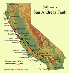
Sunday, September 19, 2010
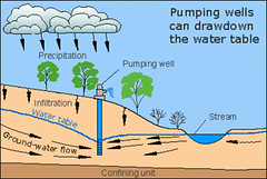
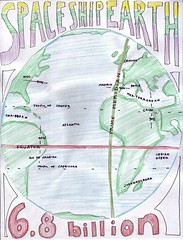
World geography project: what's inside Spaceship earth
Using
a) layers of paper and with
b) color, create an
c) annotated (well-identified by easy-to-read labels) representation of these elements of Spaceship Earth.
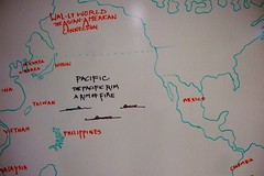
Your image will be based on these illustrations in World Geo: the Tectonic Plate Boundaries map, p 43, and The Earth's Layers graphic, p 41.
- N Amer Plate
- S Amer Plate
- African Plate
- Eurasian Plate
- Arabian Plate
- Indo-Australian Plate
- Earthquake Zones
- Arrows indicating direction of tectonic forces
- core (esp note nickel, molten)
- mantle (esp see pliable, magma, thickness)
- crust (see both thick and thin)
- watery planet
and add explanations for, from pp. 45 - 47:
- Ring of Fire
- subduction
- spreading
- converging
- faulting
- Original, jazzy title
- Documentation at bottom right.
- Legibility
- Neatness
- Completeness of the identifications.
Scored by end of period.
5 pts.
Quiz on this material on Th/Fri.
a) layers of paper and with
b) color, create an
c) annotated (well-identified by easy-to-read labels) representation of these elements of Spaceship Earth.
Your image will be based on these illustrations in World Geo: the Tectonic Plate Boundaries map, p 43, and The Earth's Layers graphic, p 41.
- N Amer Plate
- S Amer Plate
- African Plate
- Eurasian Plate
- Arabian Plate
- Indo-Australian Plate
- Earthquake Zones
- Arrows indicating direction of tectonic forces
- core (esp note nickel, molten)
- mantle (esp see pliable, magma, thickness)
- crust (see both thick and thin)
- watery planet
and add explanations for, from pp. 45 - 47:
- Ring of Fire
- subduction
- spreading
- converging
- faulting
- Original, jazzy title
- Documentation at bottom right.
- Legibility
- Neatness
- Completeness of the identifications.
Scored by end of period.
5 pts.
Quiz on this material on Th/Fri.
Saturday, September 18, 2010
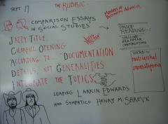
Indie work - comparison essays
Students wrote their first in-class essay this week. It was a brief comparison of Larkin Edwards and Henry M Shreve. Here's a teacher's sample essay:
The Diplomat and The Engineer: a comparison of Larkin Edwards and Henry Miller Shreve
"Rnnnggg-rnggr," was the sound made by the winches on the work boat designed by Henry Miller Shreve. It was snagboat. Its task was to wrench giant logs from the muck of the Red River as Shreve led the clearing of the Great Raft. A few miles away another pioneer, Larkin Edwards, smoked a peace pipe with Tarshar, chief of the Caddo people.
By learning the language of the Caddo the thoughtful Edwards was able to help the tribe as their interpreter, says caddohistory.com. In the 1835 negotiations which led to the US take-over of the Caddo lands in the Red River Valley, Edwards was given a gift of one square mile of land. He sold that land to the speculators who founded Shreve Town.
Meanwhile, the clearing of the river channel by Shreve ensured that settlers would fill the North Louisiana river bottom. In the process of clearing the raft, Shreve happened to cut off the river bend in which Edwards had established a store and post office. Edwards' site, the Coates Bluff landing on Stoner Hill, lost its river traffic and business.
But the port of Shreve Town prospered.
Indie work this week:
Research and compare as in the guidelines above -
- Mark Zuckerberg and the duo of Larry Page and Sergei Brin
Friday, September 17, 2010
Pratt Industries: recycling for Shreveport and many other cities
Pratt Industries (USA) is a leader in recycling and the environment. The company is one of the world's largest privately held manufacturers of paper and packaging materials, according to Hoovers.com.
Pratt has seven divisions:
recycling,
mills,
corrugating,
converting,
displays,
packaging systems, and
national accounts.
Its products, which include container board and corrugated sheets, are sold to clients such as Rubbermaid and Pringles.
Pratt Industries operates some 50 plants in about 20 states in the US and Mexico. Founded in 1948 by Leon Pratt, grandfather of current chairman Anthony Pratt, the company is owned and controlled by Australian-based Pratt family investment vehicle Visy Industries.
Businessweek.com adds,
Pratt Industries (USA), Inc. operates as a paper and packaging company in the United States and Australia. It also operates paper mills, recycling facilities, and sheet and box plants. In addition, the company offers corrugated products for durable and non-durable goods, including lighting, electronics, glass, telecommunications, automotive, pharmaceuticals, toys, sporting goods, wine and spirits, vegetables, fruits, pizza, poultry, meats, and fish. Further, it offers custom-made packaging solutions and services, such as protective packaging, bulk boxes, triple wall, partitions, and technical services. Further more, the company designs and manufactures display systems and packing machinery. ...
Pratt Industries (USA), Inc. operates as a paper and packaging company in the United States and Australia. It also operates paper mills, recycling facilities, and sheet and box plants.
In addition, the company offers corrugated products for durable and non-durable goods, including lighting, electronics, glass, telecommunications, automotive, pharmaceuticals, toys, sporting goods, wine and spirits, vegetables, fruits, pizza, poultry, meats, and fish.
Further, it offers custom-made packaging solutions and services, such as protective packaging, bulk boxes, triple wall, partitions, and technical services. Further more, the company designs and manufactures display systems and packing machinery.
Pratt Industries (USA), Inc. was founded in 1948 and is headquartered in Conyers, Georgia. It has locations in Conyers and East Point, Georgia; Duncan, South Carolina; Raleigh and Charlotte, North California; Staten Island, New York; Memphis, Humboldt, and Nashville, Tennessee; Mason, Springfield, and Lewisburg, Ohio; Allendale, New Jersey; Grand Rapids, Michigan; Oklahoma City, Oklahoma; Valparaiso, Indiana; Wichita, Kansas; Dallas, Texas; Kansas City, Missouri; Wichita, Kansas; Bentonville, Arizona; Bessemer, Alabama; New Orleans, Louisiana; and Ashland, Virginia.
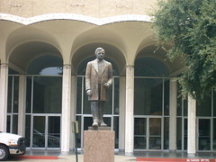
Mary Bennett Cane, Shreveport's first important businesswoman as well as founder of Cane City, later Bossier City

Mary Bennett Cane: a representation of the founder of Cane City, later Bossier City
Originally uploaded by trudeau
Mrs. Cane was the mother of of both Shreveport and Bossier City. One of the early names for Bossier City was "Cane City."
She and her first two husbands were business partners of Henry Shreve. They were here when Shreve arrived.
She survived both husbands, married a third and divorced him.
She was the area's the most successful businesswoman during the 19th century. Mary Bennett Cane is buried in Shreveport's Oakland Cemetery.
Bossier got its name from Pierre Evariste Jean-Baptiste Bossier (1797 – 1844). He was a soldier, planter, and politician born in Natchitoches, Louisiana.
He was a general in the state militia. Bossier was also a member of the Louisiana state Senate from 1833 to 1843. He served in the U.S. House of Representatives from north Louisiana from 1843 until his death in Washington, D.C.
vocab of the day -
onomatopoeia - a word that imitates or suggests the source of the sound that it describes.
sympatico - one who gets along well with or goes well with another or others; compatible or congenial.
matriarchal (from mater, Latin for "mother") - society, in which the leading role is taken by the women.
Caddo lifestyle was matrilineal, says ehow.com, with descent and heritage traced through the female line. Every Caddo belonged to a clan named for an animal that was associated with the female line.
Wednesday, September 15, 2010
Cyberbullying an issue in Upfront magazine: "Technology and the law"
Students have read the article "Technology and the law" in Upfront magazine.
Discussion touched on cyberbullying. Students were divided as to whether a law would help ameliorate the lives of students who were attacked.
The nature of democracy was observed. Democratic decision-making is a lengthy process, accompanied by much debate.
The adversary system of US government was introduced. A struggle between liberals and conservatives is normal and healthy under the adversary system. Also acting as adversaries some of the time are the 3 branches of govt: the legislative, executive and judicial. The 3 branches check, or stop, and balance each other.
From the Greek: demo, "the people" and cracy, "rule by."
See a digital version of the magazine online. .
Tuesday, September 14, 2010
Demographics, the study of populations
Demographics are the characteristics of a human population as used in government, marketing or opinion research, or the demographic profiles used in such research.
Commonly used demographics include
gender,
race,
age,
income,
disabilities,
mobility (in terms of travel time to work or number of vehicles available),
educational attainment,
home ownership,
employment status, and even
location.
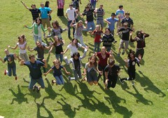
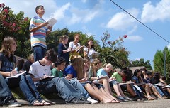
Therefore my observational demographic profile of the group
in the photo -
50% female, 99% white, median age 32, income 40,000, mobility 100%, education: college degree, home owners 40%, 70% employed,
90% East Shreveport.
Notable demographics:
- The US "baby boom" generation was unusually populous.
- Impoverished nations: the people tend to have large families so that the children help support the family income. These nations cannot afford a welfare or social security system. The children are expected to aid the parents in time of illness or in advanced age.
- wealthy nations: the people tend to have the smallest number of children.
From Wikipedia:
Japan has one of the highest life expectancy rates in the world, at 81.25 years of age as of 2006.[122] The Japanese population is rapidly aging, the effect of a post-war baby boom followed by a decrease in births in the latter part of the twentieth century.
The changes in the demographic structure have created a number of social issues, particularly a potential decline in the workforce population and increases in the cost of social security benefits such as the public pension plan. Many Japanese youth are increasingly preferring not to marry or have families as adults.[124] Japan's population is expected to drop to 100 million by 2050 and to 64 million by 2100.[123] Demographers and government planners are currently in a heated debate over how to cope with this problem.
Commonly used demographics include
gender,
race,
age,
income,
disabilities,
mobility (in terms of travel time to work or number of vehicles available),
educational attainment,
home ownership,
employment status, and even
location.
Therefore my observational demographic profile of the group
in the photo -
50% female, 99% white, median age 32, income 40,000, mobility 100%, education: college degree, home owners 40%, 70% employed,
90% East Shreveport.
Notable demographics:
- The US "baby boom" generation was unusually populous.
- Impoverished nations: the people tend to have large families so that the children help support the family income. These nations cannot afford a welfare or social security system. The children are expected to aid the parents in time of illness or in advanced age.
- wealthy nations: the people tend to have the smallest number of children.
From Wikipedia:
Japan has one of the highest life expectancy rates in the world, at 81.25 years of age as of 2006.[122] The Japanese population is rapidly aging, the effect of a post-war baby boom followed by a decrease in births in the latter part of the twentieth century.
The changes in the demographic structure have created a number of social issues, particularly a potential decline in the workforce population and increases in the cost of social security benefits such as the public pension plan. Many Japanese youth are increasingly preferring not to marry or have families as adults.[124] Japan's population is expected to drop to 100 million by 2050 and to 64 million by 2100.[123] Demographers and government planners are currently in a heated debate over how to cope with this problem.
Sunday, September 12, 2010
Guidelines for comparison essays in geography class indie work
The rubric (required elements) that will guide essay writing in geography class includes:
1. Colorful opening. There are 3 recommended ways to create an interest-getting opening: a) use a quote b) ask a question c) write with vivid description.
2. Blend the topics continually in the paper. Do not write a block of material about one topic and then write a separate block about the other topic. Integrate the topics as you offer insight and evidence.
3) Use comparison terms:
* different from,
* the same,
* Both,
* similar to,
* Neither, ... nor,
* like X is (adjective),
* ... than X is (adverb) than.
* both, ...
* either...or
* likewise
* similarly
* although,
* but neither...
* nor
* however
* on the other hand
4. Specific examples must be used to support generalities. An example: generality - The Incredibles was an awesome movie. specific - The Incredibles appealed to me because the characters (especially the mom and the teen sister) were believable. They sounded like people I know.
5. Grammar counts.
6. Spelling, too. When in doubt, see a dictionary or ask me.
7. Punctuation is paramount. Again, ask me or your Grammar Check software.
8. Include documentation via "according to ...". This means include your source - from World Book to your little brother - in the body of your writing. Usually you place it at the end of the first or second sentence, says Grammar For Today.
9. Write a snappy title. Ways to make a title fun are to tweak a song or movie title or use alliteration. Also, write an explanatory subtitle. Example: "Dinkas are Incredibles;" "Many refugees from the Sudanese Dinka tribe have moved from poverty in east Africa to comfort in the US."
10. Finally, please don't put quotation marks around your title - unless you are quoting someone.
Indie work: comparing Henry Miller Shreve and Larkin Edwards
Indie work topic:
Comparing the diplomat-pioneer Larkin Edwards to engineer-pioneer Henry Miller Shreve.
You may research the fellows via google as well as quote your teacher's notes.
Comparing the diplomat-pioneer Larkin Edwards to engineer-pioneer Henry Miller Shreve.
You may research the fellows via google as well as quote your teacher's notes.
Open notes quiz Tues/Wed: 5 themes of geography and mondotrudeau notes
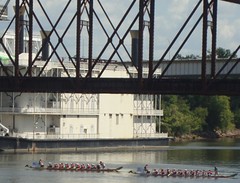
Place, Region and Location were featured in class last week as we studied the relative location of Magnet and the factors which inspired the founding and growth of Shreveport.
Notice the cross-cultural tourism event in the illustration: the Dragon Boat Races on the Red River. While I'm sure the Caddo peoples also raced boats, theirs were heavy dug-outs. These Chinese craft are based on ancient and heavy log-based designs. But the modern craft are light and of modern construction.
The team paddling sport of dragon boat racing originated in China over 2000 years ago, says Wikipedia.
Chinese dragons are traditionally believed to be the rulers of rivers and seas and dominate the clouds and the rains of heaven. There are earth dragons, mountain dragons and sky or celestial dragons (Tian Long) in Chinese tradition.
The races are associated with big celebrations in Hong Kong, Shanghai, on the Yangtze River, and in other East Asian nations such as Malaysia and Singapore.
The city of Vancouver, Canada, is also known for its dragon boat enthusiasm. Wonder why?
Quiz: about 14 mult-choice questions.
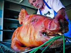
Cochon de lait is the Cajun French term for a pig roast
The pig was the universal protein source for pioneers in Louisiana. When the winter days hit their lowest temp, the men gathered to butcher the hogs. Of course, every bit of the porker was made into edible items, from snout to feet to tail.
The Cajuns have a special event called Cochon de Lait. It literally translates from French to English as "pig in milk", but would be better called a "suckling pig," says David Walker.
He says, "A Cochon de Lait is basically a cajun pig roast of a whole young pig. The pig is slow roasted for 6 to 12 hours. That is what makes a Cochon de Lait an event rather than just cooking a meal. It's an extended "male bonding", "story telling", "bull shooting", "beverage of your choice drinking", "fire tending" event!"
Today ecologists recognize that the enormous amounts of phosphates emitted by pigs endangers the environment. Phosphates drain into rivers and seas and cause "dead zones."
But scientists in Australia have found a way to get pigs to absorb phosphates. Called the Enviropig, the new swine have been genetically engineered to aborb up to 50% more phosphates, says Popular Science monthly.
Saturday, September 11, 2010
Shreveport in Place and Location: the Texas Trail and Coates Bluff settlement
As Americans headed West, says caddohistory.com, some people sent their possessions ahead on steamboats up the Red River. The families traveled on horseback or in wagons, frequently traversing this area because it was higher ground. This was known as the Texas Trail numerous years before Shreveport was founded.
James Huntington Cane and William Smith Bennett opened a store in a one-room cabin about 1832 and called it “Cane’s & Bennett’s Bluff.”
Saloons, gambling houses, and dance halls appeared on Commerce Street, giving entertainment to those who had arrived here in the course of moving westward. 2
When the Caddo Indians sold their land to the United States in 1835, they gave a section of the land to their friend and interpreter, Larkin Edwards, who had arrived from Tennessee at the time of the Louisiana Purchase. 3
Edwards sold the land in that same year to Angus McNeill, who located a claim where Shreveport was built. McNeill along with Cane, Bennett, Thomas Taylor Williamson of Arkansas, Sturgis Sprague from Mississippi, Bushrod Jenkins from Natchitoches Parish, James Belton Pickett from South Carolina, and Henry Miller Shreve from Pennsylvania were the founders of the Shreve Town Company on May 27, 1836. 4 These seven investors established the town and invited Shreve to plat it (lay out officially measured sections).
Your teacher has pointed out that in fact they were land speculators; their investment was a gamble.
It was born “Shreve’s Town” and renamed “Shreveport” in 1839. 6 This was the second city in Louisiana, planned because of the fertility of the land and the location along the Red River after it was opened. 7 They formed a community measuring eight streets long and eight wide with the Public Square on Block 23.8 These streets now form present-day downtown Shreveport.
With Texas gaining its independence in 1836, Shreveport’s main street was named Texas Trail and renamed Texas Avenue after its extension. Caddo Street was named for the Caddo Indians, who first owned the land, and Cotton bears the name of the area’s staple crop. Hopeful names were given to Commerce and Market Streets, as the founders anticipated their development into prosperous business streets; the first market house also stood at the northwest intersection of Texas and Market Streets. Fannin, Travis, Milam, and Crockett Streets honor those who died at Goliad, the Alamo, and San Jacinto. Edwards Street remembers Caddo Indian interpreter Larkin Edwards, McNeill Street bears the name of the Shreve Town Company’s president. Spring Street called to mind the nearby springs,
which gave water to the cattle and pasture of the owner of a nearby pioneer boarding house. Lake Street was fittingly named, as it was interrupted by Silver Lake. 9
Shreveport had been challenged by another rising community, Coates Bluff, which had opened the first area post office on April 10, 1838. 10 The community, located on what is now Stoner Hill, had begun with a trading post owned by McLeod and Carr.
Using the Eradicator, Shreve dug a ditch across the forty-two-yard neck of the river circle that went around Coates Bluff, leaving the community dry. 11
Thursday, September 09, 2010
Syllabus, Magnet geography / Trudeau / 2010-2011
As guided by the comprehensive curriculum, which insures topical uniformity across the parish . . .
Aug: basic skills in geography (2 weeks)
Sept: US & Canada (4)
Oct: Central & South America & the Caribbean (3) also, Europe begins.
Nov 4: schools closed for presidential election.
Nov: Europe (4)
Dec: Russia & Northern Eurasia (3)
Jan: Middle East (SW Asia) & Mediterranean Afric
Feb: Sub-Saharan Africa (3)
March: South & Central Asia (3)
April: East Asia (3)
May: Australia & Oceania
Geography is a social studies regimen in which Robert Trudeau's students take a humanities approach appropriate to a college-oriented high school curriculum.
The class integrates
* study of language (especially Greek and Latin roots)
* literature (often through classic films such as Gandhi and Lawrence of Arabia)
* architecture (students make abbreviated models of buildings such as the Taj Mahal and the Great Mosque at Mecca)
* cuisine (taste this Japanese nori, or cultivated seaweed, and write down 5 sensory words)
* music (ethnic or classical music is played in the classroom daily)
* map study (students can draw and label a map comprising the entire world by year's end), * economy (per capita income, standard of living) and
* history (empires, wars, rulers).
Subject-matter units may vary in order and substitutions may occur according to world conditions.
Skills emphasized in geography class comprise the higher thinking modes:
questioning
evaluation
composition
analysis
synthesis
The primary theme is that students are encouraged to gather information about a nation / culture and compare it to previously-studied nations.
Quizzes focus on reading and organizational skills. Reading comprehension is a key to this class as well as to your future success in school and work.
Analysis: to take apart the elements of a culture:
* land - ex., from the cold Himalayas to bustling Shanghai
* resources - petroleum, alumina, arable land, work ethic
* history - golden eras, wars, colonialization, empire
* arts - architecture, painting, sculpture, literature, clothing
* philosophy - What is the theme of Confucianism? can you identify the difference between Buddhism and Taoism?
* government - authoritarian, socialist, democratic
* economy - free enterprise, government controlled, modified
* ethnic groups - Mongolian, Chinese, Japanese, Korean, Creole
* language - Latin, Greek, Sanskrit, Hindi, Mandarin Chinese
* religions - the degrees of fervor in Christian, jewish and Muslim communities
Synthesis: combine elements of cultures to offer a theme or thesis.
Ex., a) Write a brief essay showing the similarities in Chinese and American cultures. b) Create an annotated map that shows the influence of Buddhism across several nations in Asia.
Questions which accompany each class activity emphasize interpretation and comparison.
Ex.: if most of the world's poor population cooks over charcoal, what are the indirect stresses on the environment? answer: not only air pollution, but deforestation (charcoal being the product of partially burned trees). Deforestation leads to excessive erosion of topsoil and to an extreme danger: a decline in agricultural production.
Learning styles exploration and communication styles evaluation are the subtext for this social studies class.
* How effective is repetition? How can repetition be made bearable?
* How does art - ex., illustrations - enhance learning? Does color add significant impact to communication?
* Does a hands-on activity (for instance, a puzzle map) enhance retention of material?
* Does a multiple-choice quiz create involvement in a general audience? Is multiple-choice more appealing than a fill-in-the-blanks quiz? Why?
If students both see material on the board, write it down, add an illustration, add color, create a quiz and write an essay on the material do we reach a high level of understanding and retention? That is this teacher's idea of a thorough lesson.
Composition engages students in the highest mode of thinking.
Written communication must be
orderly; logic and chronology and thoughtful transitions must be in evidence. Writing must be:
* detailed - examples and documentation make a full-bodied article.
* lively - a snappy title and colorful opening are mandatory.
* credible - "according to" and a source must accompany all fact and even presentations of opinion. Meanwhile, we also avoid plagiarism.
* insightful rather than lengthy - while offering an adequate amount of evidence is important, the highest level of writing demonstrates questioning, offers a thesis and demonstrates leaps of imagination.
Materials
Rand McNally Quick Reference World Atlas is used in class virtually every day and on every quiz. It comprises demography, topography, political life, and spatial relationships. The RMQRWA offers students opportunities for exploration, memorization and global insight.
Presentations and activities developed by your teacher from material in the NY Times, Public Broadcasting, National Geographic, World Book and numerous additional sources.
The Class Web Site at http://mondotrudeau.blogspot.com is designed to help create a partnership in learning between student, teacher and parents. Assignments, activities, notes, announcements and tests are updated regularly. Here you will find opportunities for bonus credit writing assignments and a place to catch up on notes and tests when you are ill or otherwise absent.
Guest speakers and field trips offer a first-hand learning opportunity. Students' questions are highly valued during these experiences. Post-activity essays afford us an opportunity to evaluate the experience.
Evaluation
Memorization is exercised by a regular schedule of map tests. Spelling counts, as it does all one's life.
Open Notes Multiple Choice Tests offer a challenge to students' ability to take accurate notes, to organize their notes and to use pertinent resources, such as notes from the class web site and resource books in the classroom. Also measured by Open Notes Tests is the ability to read questions and the ability to use deduction in choosing answers.
Essays
Student growth in communications and thinking skills are challenged in the most stringent way by essay questions. Students are given evidence in handouts and expected to follow essay guidelines.
Projects
Special teamwork assignments such as making Powerpoint presentations are an important part of a varied academic diet.
Independent work
Essays are the primarily recommended form of independent work. Each week I suggest several topics for research and writing. From time to time I may allow students to bring a taste of a foreign cuisine to school. I also encourage audio-visual projects such as video and other photography projects.
Email is my way of extending my care to the 143 students I teach each day. Email may be used for bonus work or regular assignments when needed.
Parents and students' questions are answered efficiently by the use of email.
Benchmarks
Instruction and student achievement will be based on these items, as mandated by the Department of Education:
Solving geographic problems by use of geographic materials.
Organizing material by formulating mental maps.
Determining how location and social, cultural, and economic processes affect the features and significance of regions.
Analyzing the structure and interconnectedness of regions.
Determining the social factors that impact human systems.
Analyzing demographic materials.
Comparing economic systems.
Examining the role of technology in human achievement.
Describing the earth's physical challenges and searching for solutions.
Using concepts such as chronology and conflict to analyze history.
Interpreting primary and secondary sources.
Conducting research in efforts to analyze historic issues.
Analyzing cause and effect relationships.
Analyzing and demonstrating an understanding of nations' changes in the modern era.
Analyzing the origins, central ideas and impact of great religions and philosophies.
Tracing the interconnectedness of peoples through research into national and cultural forces.
Grade level Expectations
Competent use of all sections of the atlas.
Mental mapping.
Comparison of cultures.
Use of graphs and diagrams in communicating geographic material.
Drawing conclusions about locations based on the evidence in maps and graphs.
Analysis of economic forces.
Demonstrate an understanding of demographics.
Inquire into the forces that create war and peace.
Describe the cultural forces that link the world's regions.
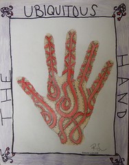
Wednesday, September 08, 2010
Quiz #2: Hydrologists & Kinesiologists
1. The Ozark Mountains: a) Northern Arkansas b) Southern Arkansas.
2. Before the 1700's there was quite a conflict between the a) Osage and the b) Iroquois. Which was the more powerful tribe?
3. The date of the Louisiana Purchase: a) 1783 b) 1803 c) 1835 d) 1836.
4. Which is sweeter, more succulent (juicy) and more aromatic (appealing aroma), the a) pimento, or cherry pepper, or the b) red bell pepper?
5. The Spaceship Earth project is an example of learning that we may term
a) tactile b) holistic c) kinetic d) mnemonic.
6. With a population of 6.8 billion, most people on earth are competing to get an adequate supply of jobs, food, housing and __ . a) living space b) money
c) ecosystem d) water.
7. One of these nations has a totalitarian government, one which has absolute power in regards people's lives. a) China b) India c) Asia d) Africa.
8. 40N, 74W: a) Beijing b) New York City c) Paris d) Chicago.
9. The most important item learned in the recent Mississippi Valley map quiz:
a) 10 states b) tributaries c) memorization d) mnemonics.
10. A hydrologist might be a geologist. T / F
11. The Caddos, Celts, Zulu and Choctaw are indigenous peoples but the aborigines of Australia are not what we call indigenous. T / F
12. There is a great ocean current which flows around the peninsula of Florida and moves slowly north along the Atlantic coast. It is the: a) equatorial b) Canary c) North Atlantic d) Gulf Stream.
13. The devastating Katrina sequence seen in New Orleans in 2005: a) wind-rain-broken levees-flooding b) rain-broken levees-wind-flooding c) flooding-broken levees-wind-rain.
14. Relatively large Island which visibly separates the Caribbean from the Gulf of Mexico: a) Cuba b) Florida c) Venezuela d) Haiti.
1. Northern Ark.
2. The Iroquois; return to the Caddo history to see the explanation.
3. 1803
4. pimento
5. tactile
6. water
7. China
8. NYC
9. mnemonics
10. T
11. F
12. Gulf Stream
13. wind-rain-broken levees-flooding
14. Cuba
Henry Miller Shreve, the steamer & flat boat and a modern log jam
In the beginning was the flat boat. Men wielding poles gave it direction; it used the current for most of its conveyance. Sides of salted bacon, barrels of molasses and stacks of animal pelts were among the products of the region which could be shipped south by flat boat.
But no one would get rich on the trade engendered by flat boats.
The development of this region was first spurred by steam boats.
Henry Miller Shreve was the developer of the shape and style of the Mississippi River Steamboat, according to author and professor Gary Joiner.
His design featured -
- a wide, shallow draft hull -
- 2 decks
- boiler on main deck
- improved engine
The steamboat brought wealth to the Red River valley through increased trade. Imagine giant stacks of cotton bales on the front and rear decks of a steam boat.
Shreve also enabled river traffic by clearing the Red of a log jam called the Great Raft. By one account the obstructions in the channel stretched from Shreveport to Baton Rouge.
He developed a steam-powered work craft called a Snag Boat to fully leverage the clearing of the river of the masses of heavy trees and debris. The Snag Boat featured a split front hull topped with an armature, or frame, that enabled the men to better use a winch and pulley to extract heavy trees from the river sediment.
Cave-ins of dirt and trees were the main elements of the log jam. The jam was so thick that islands developed in the main channel.
Today Shreveport faces a transportation problem somewhat similar to that of the Great Raft. It is the air access problem due to the oddly high cost of flying in or out of Shreveport Regional Airport.
We need a visionary in the mold of Henry Shreve to clear the obstructions in local air traffic. If we can find a way to lower ticket prices to a competitive level, this region will surely develop more wealth and comfort.
Coates Bluff Nature Trail, adjacent to Magnet, Stoner Elem and Montessori
Here is a look at the North-South open space on the river side of Magnet, Stoner Elem and Montessori for Shreveport. This area, blank on the map, is an old river bed.
When the Great Raft clogged the main body of the Red River, side channels were developed. This former river bed, now an open space and wooded bottom, was a loop. The neighborhood called Anderson Island was created by this and other loops of the river.
This wooded area is being developed into a nature trail by a civic group called A Better Shreveport. The person who identified this area was nature education specialist Jon Soul of Montessori. .
Mapping overview / East Shreveport; Magnet and neighbors
Classes are reviewing the 5 Themes of Geo and the mapping sensibility that accompanies the sense of place, location, region, movement and human-environment interaction.
On this map students will be able to sketch and identify -
Red R.
Teague Parkway
Fant Parkway
Stoner Ave
Youree Dr
Olive St
Magnet / Valencia Park
Students were helped in adding
Stoner Hill Elem
Montessori School for Spt
and identifying a North-South open space on the river side of three schools: Magnet, Stoner Elem and MSS. This area, blank on the map, is an old river bed.
When the Great Raft clogged the main body of the Red River, side channels were developed. This open space / wooded bottom was a loop of the river. The neighborhood called Anderson Island was created by this and other loops of the Red.
This wooded area is being developed into a greenway or nature trail by a civic group called A Better Shreveport. The person who identified this area was nature education specialist Jon Soul of Montessori. .
Reviewing the 5 Themes of Geography
The 5 Themes of Geography include
- Location, both relative location and absolute location.
- Place, including physical characteristics of place and human characteristics of place.
- Human-environment interaction, comprising human adaptation to the environment, human modification of the environment, and human dependency on the environment.
- Movement, which includes movement of people, movement of goods and movement of ideas.
- Regions, subdivided into formal regions, functional regions and vernacular regions.
Review quiz
Which item of the 5 Themes is indicated by
1. Shreveport's humid climate.
2. Tax incentives (rewards) for movie production in Shreveport.
3. The Gulf Coastal Plain includes Shreveport.
4. Shreveport's indigenous people were expelled around 1835.
5. Shreveport is some 300 miles north of New Orleans.
6. The Fant Parkway was built alongside the Red River in the 1970's.
7. People in the media sometime refer to this area as "S-B Land."
8. Hispanic people comprise (make up) about 2% of the population.
9. Eldorado and Sam's Town are casinos (casino means "house" in Italian) that were added to the Shreveport side of the Red River.
10. Water from the Red River can be purified for use as a municipal (having to do with a city) water supply.
The S-B map:
1. Name the curving, NW to SE thoroughfare (area where things are moved).
2. Name the principal N-S conveyance (area where things are moved).
3. Spt's downtown buildings are north of I-20. T/F
4. Magnet is across the red from a major institution in Bossier:
a) La Boardwalk b) Diamond Jacks / Isle of Capri Casino c) Barksdale Air Force Base.
5. I-20 is basically a highway that carries traffic a) East-West b) North-South c) NW - SE across the US.
1. Human-Environment adaptation
2. Movement of ideas and goods.
3. Place / physical characteristics.
4. Movement of people.
5. Location, relative.
6. Human-environment modification.
7. Regions, vernacular.
8. Place, human characteristics.
9. Human-environment modification.
10. Human-environment dependency.
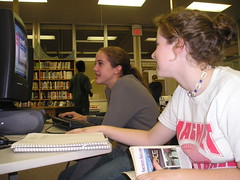
Stoner Ave at Fant Parkway: Riverscape development, Shreveport, will be adjacent to Magnet
In this illustration you see the plan for a housing development, a neighborhood, that will be built adjacent to Magnet on the Fant Parkway side of the campus. It is to be called Riverscape.
In the illustration can you tell that the person's hand is pointing to Magnet campus? The finger is on the tennis courts.
Above is the campus proper, with PAC, central wings and even E wing. Above E wing is the outline of the oval track. At the top is Stoner Ave.
In the illustration can you tell that the person's hand is pointing to Magnet campus? The finger is on the tennis courts.
Above is the campus proper, with PAC, central wings and even E wing. Above E wing is the outline of the oval track. At the top is Stoner Ave.
Monday, September 06, 2010
Back to school night: Thurs, Sept 9, 5:30 pm
Back to School Night will take place on Thursday, 9/9/10, beginning at 5:30 PM.
Parents of Freshmen should meet in the Performing Arts Center, while parents of upperclassmen should meet in the 1st Period classroom of their child.
Looking forward to meeting you!
If you cannot be there, don't hesitate to ask questions via email: trudeau11@gmail.com.
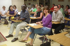
Parents of Freshmen should meet in the Performing Arts Center, while parents of upperclassmen should meet in the 1st Period classroom of their child.
Looking forward to meeting you!
If you cannot be there, don't hesitate to ask questions via email: trudeau11@gmail.com.
Class of 2014 Speed Meet on Fri, Sept 10, 6:30 - 8:30 pm
The Freshman Speed Meet is a mixer designed to get all the first-year students better acquainted. Organized by parents, the event will feature food, prizes and the chance for everyone to broaden their networks.
In the cafeteria from 6:30 to 8:30 pm.
More info: trudeau11@gmail.com
In the cafeteria from 6:30 to 8:30 pm.
More info: trudeau11@gmail.com
Sketching / mapping the Magnet campus
Students will prepare for walking tours of the campus by reviewing mapping and land forms. Also, review the 5 themes of geography.
If it makes any difference to you, please wear "walking shoes" this week.
- will make sketches of 3 aspects of campus view: a) front of campus - aesthetic view. b) looking up at campus hill from old river valley below the tennis courts. c) looking across campus wings from 2nd floor of E wing.
- sketch and compare with aerial view via Google maps.
- observations on advantages of each view via discussion and notes.
- viewing campus in context of city: connecting streets, proximity to other institutions, centrality, implications for future.
- Brief essay describing the campus in terms of the 5 themes. 5 pts.
Saturday, September 04, 2010
Bees at RW Norton Art Foundation, Shreveport; why shouldn't Magnet have bee hives, too?
Gepgraphy students, let's explore a plan to contact Hummer & Sons, local beekeepers, to add hives to the Magnet campus.
Are you aware of the precipitous loss of bees across the country?
"The decline in the US bee population, first observed in 2006, is continuing, a phenomenon that still baffles researchers and beekeepers.
Data from the US Department of Agriculture show a 29 percent drop in beehives in 2009, following a 36 percent decline in 2008 and a 32 percent fall in 2007.
This affects not only honey production but around 15 billion dollars worth of crops that depend on bees for pollination.
Scientists call the phenomenon "colony collapse disorder" that has led to the disappearance of millions of adult bees and beehives and occurred elsewhere in the world including in Europe.
Researchers have looked at viruses, parasites, insecticides, malnutrition and other environmental factors but have been unable to pinpoint a specific cause for the population decline," says breitbart.com.
Friday, September 03, 2010
Because of the British Empire, we look for this sign when traveling in almost any nation
Water Closet, as a word for restroom, was a term spread across the globe during the time of the British Empire (1600's - 1900's).
Signage in places such as train stations, parks and hotels is usually abbreviated to WC.
You'll see signs for the WC on every continent and even in nations that were not technically owned by the British.
It's a term even used in some classes at Magnet.
Signage in places such as train stations, parks and hotels is usually abbreviated to WC.
You'll see signs for the WC on every continent and even in nations that were not technically owned by the British.
It's a term even used in some classes at Magnet.
Indie work (independent): building bonus points and raising the average in geography / Trudeau
How to excel in geography class - and at Magnet
Trudeau's web site notes print-out
High school is a game. Suss each teacher's game rules and you'll feel better and better. You will find that each instructor has particular priorities and patterns. Eventually will be able to sense and anticipate how to excel under each teacher.
Students under Robert Trudeau:
1. Slow down as you read and research the answers on the quizzes. Focus. Work on the accuracy of your reading.
Have a print-out of your web site notes. Use a highlighter. Read the web site entries every night.
2. Do Indie Work, aka bonus credit work. Each week I'll put topics on MondoTrudeau that will allow you to find a good assignment. The comparison essays you write will be not be easy to compose, but you will earn important points. Indie work must be submitted via GoogleDocs.
See the essay guidelines under Comparison Essays.
3. Tutoring via after-school time or via email. If you would like extra help, I will be happy to explain and to guide you. Thursday and Fridays are good days for me to work with you. Drop me a line at trudeau11@gmail.com to set a day.
This week's indie work:
In a brief essay (about 1 page, doublespaced, typed, sent via email) compare
Shreveport to Bossier City, mostly on their demographics (statistics) and history.
Cite a source.
Thursday, September 02, 2010
No question that Otzi's an indigenous fellow
Otzi is one of the most famous aboriginal people on the planet. Some 5000 years ago he died on a mountaintop in the Austrian Alps. Some 20 years ago he was discovered in a frozen state where he had lain since 3000 BC.
Today we know a great deal about him from his clothing, weapons, his skin and even his DNA.
See more about here about Otzi the Ice man.

Today we know a great deal about him from his clothing, weapons, his skin and even his DNA.
See more about here about Otzi the Ice man.
Wednesday, September 01, 2010
5 Themes of Geography / Shreveport Bossier
Students are in small teams to write 9 multiple-choice questions using the material in my 5 Themes of Geography sheet.
In so doing, they will move to higher levels of thinking and use of imagination.
They will develop an appreciation for the mechanics of tests.
They will learn about S-B.
They will develop an understanding of the 5 themes.
Following the writing of their questions there will be a session for developing the art of presentation as they read their best questions to the class.
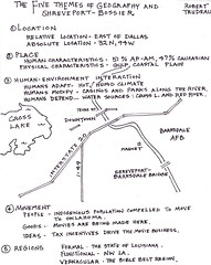
Subscribe to:
Posts (Atom)
