Complete the narrative as homework to be handed in next class.
See details below.
Open notes test the following class.
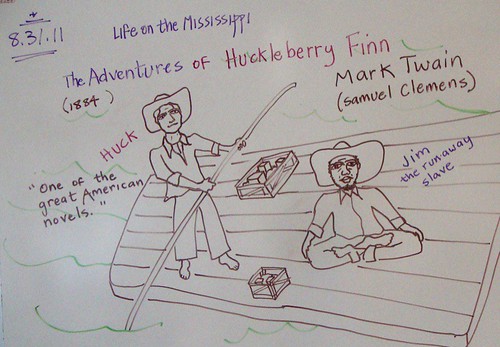
Wednesday, August 31, 2011
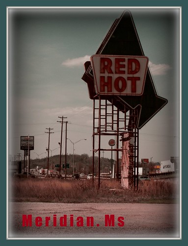
Huck and Jim, 2011, geography class narrative on river travel
12 pt narrative project: A river ride down the MIssissippi Valley
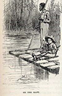
Characters - The Adventures Of Huckleberry Finn - Illustration Of Huck & Jim, a photo by Johnny Quixote on Flickr.
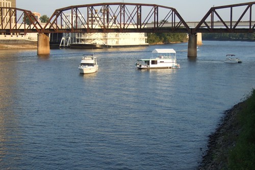
On the river with a contemporary Huck Finn - the water journey narrative
- In your river-based group (either the Ohio, Missouri, Tennessee, Arkansas or Red)
- each student writes their own copy of the third-person story
- approx 1 - 2 pages typed
- each group will have one of the 5 tributaries to begin the journey
- __12_ pts, based on grammar, spelling and construction as well as descriptive detail (3 pts).
-
A story describing the trek down a river from the headlands of a Mississippi tributary to the Gulf of Mexico.
- first and last names of your classmates on the float party (1 pt)
- type of water craft chosen for the trip (1 pt)
- examples of the supplies packed away (1 pt)
- locations by which you pass - especially nearby cities and states (please underline each city and state) (5 pts)
- passage of time
- adventures on your way (at least 2) - dangerous snags (trees, lumber, structures) in the river? threatening barges? snakes? (2 pts)
- describe the Louisiana marshes as you arrive at the Gulf of Mexico (1 pt)
- apply a jazzy title to the top of the narrative (1 pt)
Tuesday, August 30, 2011
Eid Mubarak! A celebration after the Muslim month of fasting, Ramadan

Eid al-Fitr, often abbreviated to Eid, is a Muslim holiday that marks the end of Ramadan, the Islamic holy month of fasting (sawm).
Eid is an Arabic word meaning "festivity," while Fiṭr means "breaking (the fast)", says Wikipedia.
The holiday celebrates the conclusion of the twenty nine or thirty days of dawn-to-sunset fasting during the entire month of Ramadan.
Muslims are commanded by God in the Qur'an to complete their fast until the last day of Ramadan[3] and pay the Zakat al-fitr before doing the Eid prayer.
Eid ul-Fitr is celebrated for one, two or three days. Common greetings during this holiday are the Arabic greeting ‘Eid Mubārak ("Blessed Eid") or ‘Eid Sa‘eed ("Happy Eid").
After prayers, Muslims visit their relatives, friends and acquaintances or hold large communal celebrations in homes, community centers or rented halls.
Gifts on eid (called eidi in some cultures) are frequently given to children and immediate relatives; it is also common in some cultures for children to be given small sums of money by adult relatives or friends(eidi).
Eid ul-Fitr marks the end of the fasting month of Ramadan. This has to do with the communal aspects of the fast, which expresses many of the basic values of the Muslim community; i.e., empathy for the poor, charity, worship, steadfastness, patience etc. Fasting is also believed by some scholars to extol fundamental distinctions, lauding the power of the spiritual realm, while acknowledging the subordination of the physical realm. It also teaches a Muslim to stay away from wordly desires and to focus entirely on the Lord and thank him for his blessings. It is a rejuvenation of the religion and it creates a stronger bond between the Muslim and his Lord.
Source of much of America's electricity: cheap coal from Montana
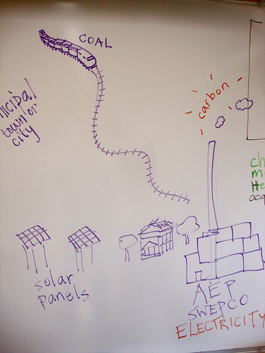
While inexpensive coal from Montana is a boon to our rapacious appetite for electricity, it is not good for the environment.
Carbon dioxide produced in the process of making electricity is harmful to the ozone.
But the alternative and renewable energy sources do not generate an adequate amount of electricity.
"Growing electricity demand in the U.S. and in the world will require increases in all generation options (renewables, coal, and nuclear) in addition to increased efficiency and conservation in its use. Coal will continue to play a significant role in power generation and as such carbon dioxide management from it will become increasingly important," says MIT.edu.
Monday, August 29, 2011
Geography: Aquifers and derricks
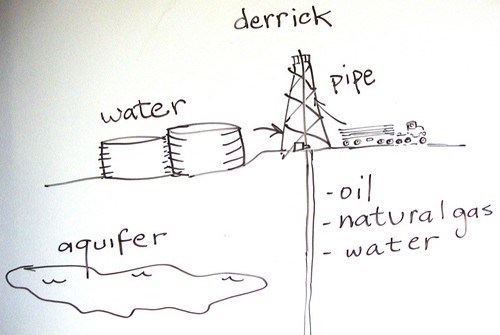
Aquifers are the underground reservoirs that supply our wells and act as the "water bank" for future water needs. .
Derricks exist so that the pipe needed to drill deep into the earth can be raised to an upright position.
- Water consumption by drilling companies is enormous. The work of the drill bit must be aided by large infusions of liquids.
- The chemicals used in drilling are mostly toxic, so petroleum companies and the public try to balance the need to drill with the need to keep water supplies safe for now and for the future.
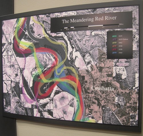
Understanding the term "regions": maps of the I-20 Corridor and the Red River Valley
Regions!
Sketch a map of the towns that lie in a region that stretches from Ft Worth to Meridian.
This region is called the I-20 Corridor.
Include in your map -
- Tx, Ok, La, Ms
- Ft Worth, Dallas, Tyler, Longview
- Shreveport, Bossier, Minden, Grambling/Ruston, Monroe
- Vicksburg, Jackson, Meridian
- add the Miss R, the 30N line
An additional region:
The Red River valley
Include in youyr sketch . . .
- Tx, Ok, Ak, La
- Wichita falls
- Texarkana
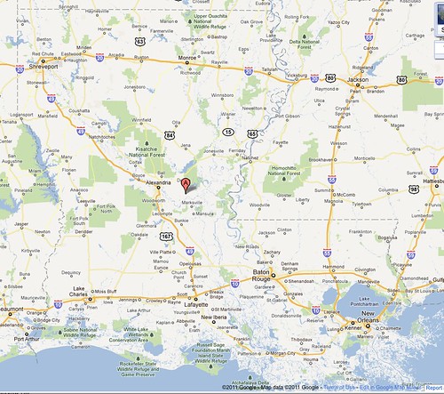
- Shreveport, Natchitoches, Alexandria
Comparing population trends using lines of latitude

Populations are not dispersed equally across the world's continents.
In your group, make an estimate of the number of cities that lie close to
- 20N
- 30N
- 40N
and, in the southern hemisphere
- 20S
- 30S
- 40S
Sunday, August 28, 2011
For your projects in world geo: a printable blank world map
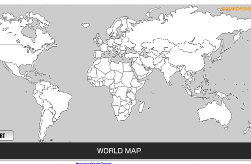
Please do not hesitate to use this map in geo class projects. Of course, there are many such maps that can be found online with minor research.
As a Magnet student you should be resourceful - find maps, review materials, background and more - without being told to do so.
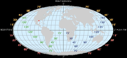
Demonstrating knowledge of the global grid: Google Earth offerslatitude/longitude displays
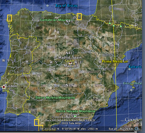
First, since you're a geography student at a top secondary school, you should download the app called Google Earth. It is an excellent tool for your future and may lead you to numerous enjoyable discoveries and to thoughtful work in several Magnet classes.
Someone in your family might have downloaded it already. Check "applications" to see whether you already have Google Earth.
One of the may things you can do with Google Earth is find a map of any city or other location and display - View - it with an overlay - the latitude-longitude grid.
That would be perfect for use in assignment 4, wouldn't it?
Shreveport Times: Take a truly regional approach to water needs
From an editorial in the Shreveport Times Aug 28, 2011:
This area's increasing demand for water exacerbated by the ongoing drought, to paraphrase Caddo Commissioner Mike Thibodeaux, are helping form the perfect storm with no storm.
Combine these two factors with the millions in oil and natural gas riches and other funds the parish governing body has been socking away the past few years, and we have truly have an opportunity to begin to address our long-term water needs.
The need is imperative, given the recently state-declared emergency in two areas of south Caddo that rely on groundwater from the falling Carrizo-Wilcox Aquifer. There, some wells have gone dry and water levels in others have fallen by 5½ feet in three weeks. Observations at other test wells show a similar situation shaping up in the Greenwood area; and there have been reports of well levels dropping in north Caddo.
Even those reliant on surface water — Cross Lake (Shreveport) and Red River (Bossier City) — are not immune. For now the problem is not the availability of water but the ability to treat it fast enough to meet demand, which rises with the heat and as the drought continues.
See the remainder of the article at the Times.
Saturday, August 27, 2011
Author John Corey Whaley of Springhill chats about his young adult novel, Where Things Come Back, at Broadmoor Library at 11 am Sat, Aug 27

Author John Corey Whaley, of Springhill, chats about his young adult novel, Where Things Come Back, at Broadmoor Library at 11 am Sat, Aug 27, says Levette Fuller.
Asking questions in the session will be Robert Trudeau, teacher, artist and blogger.
It's free. And Corey is a fluent, warm and thoughtful lad. Please join us.
Friday, August 26, 2011
K'naan: a young singer from Somalia

In exile from Somalia because of civil-war, the singer-songwriter K'naan has emigrated to Canada.
In Jonquiere, Canada, students created an elaborate lip-dub video to his best-known song, "Wavin' Flag."
On Npr.org we see K'naan giving an unplugged performance of 3 tunes.
His lyrics reference famous people and locations so much that I like him for geography class.
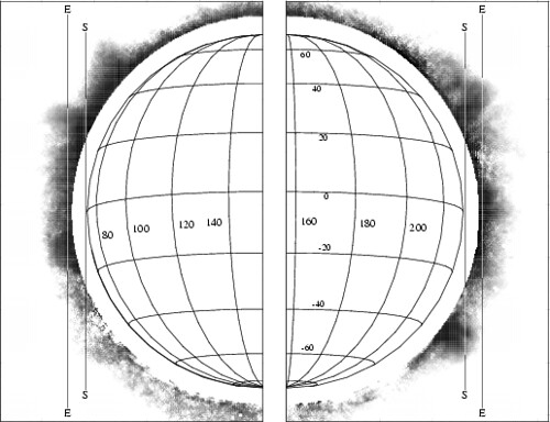
Patterns in the lines of latitude: great cities
Students will follow lines on the grid associated with notable cities to see how many additional cities can be found near these imaginary lines.
1. Shreveport: 32N, 94W
latitude partners: Dallas-Ft Worth. Find partner cities in Arizona, California and Mexico.
- Continue following the 32N line across China, India, Arabia and Africa and list the great cities to be found. Example: Tokyo is 35N: that's close enough to be included in this list.
2. Paris: 48N, 2E.
- latitude partners include cities in the Czech Republic and Ukraine.
3. NYC: 40N, 74W:
- same latitude partners include a city in China.
4. Rio De Janeiro (in the southern hemisphere) : 22S, 42W
- latitude buddies include a capital in South Africa and a coastal city in Australia.
5. List all cities lying close to the equator.
6. Compare the number of cities in the southern hemisphere to those in the northern hemisphere: which has the majority?
Thursday, August 25, 2011
Additional materials: Mississippi watershed map
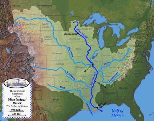
To bolster your background on the vast Miss Valley map, use this map.
Please note that the Ohio R and Tenn R make a confluence (flow together) at the point where they enter the Miss. That's at the border of Kentucky and Illinois.
What to do with the class blog? Copy and highlight

The class blog is an extension of the in-class textbook. The blog provides learning and review material for quizzes and tests.
The best way to prepare for world geography is to copy these pages - by hand or by copy machine.
Then you can read the material and go over the important points with a highlighter pen.
That was you will enhance your grasp of the considerable material that comes your way in this social studies class.
Assignment 4: copy and color a world map that shows the location of 5 cities
On a world map please show these cities and a section of the grid demonstrating the latitude and longitude of the following
- Paris, France
- Johannesburg, South Africa
- Tokyo, Japan
- Rio de Janeiro, Brazil
- Sydney, Australia
You may illustrate the intersections where the cities are found by either of these methods -
a) sketch and color by hand
b) cut and paste digitally
8 pts.
My Very Early Morning Jam Sandwich Usually Nauseates People
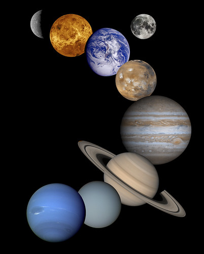
Earth's solar system with a mnemonic in the title.
- Mercury
- Venus
- Earth - and its moon
- Mars
- Jupiter
- Saturn
- Uranus
- Neptune
- Pluto (what the heck!)
Earth's crust and the other delicious parts
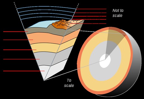
Earth has an outer silicate (sand, Portland cement, and thousands of minerals are examples of silicates) solid crust, a highly viscous )between solid and liquid) mantle, a liquid outer core that is much less viscous than the mantle, and a solid inner core.
Scientific understanding of Earth's internal structure, says Wikipedia, is based on observations of topography and bathymetry, observations of rock in outcrop, samples brought to the surface from greater depths by volcanic activity, analysis of the seismic waves that pass through the Earth, measurements of the gravity field of the Earth, and experiments with crystalline solids at pressures and temperatures characteristic of the Earth's deep interior.
Inner core: 4000 miles deep, super-hot but solid, iron & nickel.
outer core: liquid, super hot
mantle: silicon, aluminum, magnesium, iron, etc; "This mixture continually rises, cools, sinks warms up, and rises again, releasing 80% of the heat generated from the eartth's interior." - WG
crust: broken, rocky shell; plates of the crust float upon the upper mantle.
- continental drift theory
- plate tectonics, perhaps caused by interior heat.
- magma
- subduction: heavier sea plate slides beneath the lighter continental plate.
- accretion: adding to the material of the earth's crust.
- spreading: sea plates pulling apart, creating a rift (crack).
- folds: layers of rock that have been bent under pressure.
- faulting: cracks in the crust; associated with earthquakes.
- ring of fire: earthquake-prone zone that surrounds the Pacific.
Ciao!

The word "ciao" is an informal Italian verbal salutation or greeting, meaning either "hello", "goodbye", "bye" or "hi".
Originally from the Venetian language, says Wikipedia, it was adopted into the Italian language and eventually entered the vocabulary of English and of many other languages around the world.
The word is mostly used as "goodbye" or "bye" in English, but in modern Italian and in other languages it may mean "hello" or "goodbye", similar to the Hawaiian word aloha.
Where did all your body water go, dear Ramses?
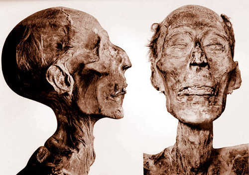
The human body consists of close to 100 trillion cells,[1] the basic unit of life.
By mass, human cells consist of 65–90% water (H2O), says Wikipedia.
A significant portion is composed of carbon-containing organic molecules. Oxygen therefore contributes a majority of a human body's mass, followed by carbon.
99% of the mass of the human body is made up of the six elements oxygen, carbon, hydrogen, nitrogen, calcium, and phosphorus.
Tuesday, August 23, 2011
Guidelines for papers & projects, 2011 - 2012

Mandatory elements for all projects and papers in geography -
1. Jazzy title (of several words) - original, colorful, lighthearted.
2. Name, date and hour in upper right corner. Please print.
3. Source or sources listed simply and briefly in the lower right corner. Ex: Google.com Maps or Wikipedia.com
4. Color.
5. Neatness of lettering and design.
6. Do not use a "key." Identifications must be placed in the correct territory.
7. Speeling counts!
8. Trim ragged edges of paper. Submit standard, full-size sheets of paper.
9. Save all papers until the end of the semester. Make a file on your computer to save papers created digitally. Btw, did you realize that you can make these geography class maps using a program like Paint?
How to identify locations on spaceship earth: cook 'em on a grid
Navigation terminology -
- Equator, O degrees latitude
- Tropic of Cancer
- Tropic of Capricorn
- Shreveport's about 32N
- NYC about 40n
- Navigation - position can be fixed with a sextant.
- Prime Meridian, O degrees longitude
- Royal Observatory in Greenwich, England
- City of Paris about 3E.
- Shreveport about 94W.
- Intl Date Line
- Navigation at sea requires a chronometer
- At the intersection of 0 degrees latitude and 0 degrees longitude, where are you?
a) North Pole
b) Atlantic Ocean
c) Greenwich, England
Hemispheres:
- Northern
- Southern
- Eastern
- Western
- cerebral
Assignment 3 / Mississippi River tributaries: Ohio R, Tenn R, Missouri R, Ark R, Red R
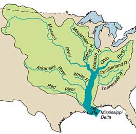
Mississippi River tributaries: Ohio R, Tenn R, Missouri R, Ark R, Red R, a photo by trudeau on Flickr.
Overview of the fertile, wealth-giving Mississippi valley map:
- 5 tributaries
- 10 states that border the Miss R
- Gulf of Mexico
- Mrs Mimal
- Mr Wiktm
- mnemonics
What is the national impact of such a region? How should you read an area with these kinds of resources?
Wealth.
Rivers enhance trade, farming, fishing, tourism and general transportation.
Asssignment 2: Shreveport, the Red River and Cross Lake
On the map that you present for homework in your next class, please sketch, label and add color to the following items -
- the downtown grid of the original streets of Shreve Town.
- the Red River.
- the Texas St Bridge
- Bossier City
- Barksdale Air Force Base
- Fant Parkway
- Teague Parkway
- I-20
- Hwy 80 / Texas Trail / Caddo Trail
- Cross Lake and Cross Bayou, which links the lake and the Red River.
- I-49.
- CMHS
Give this project a jazzy title (2 pts)
Overall total: 9 pts
Friday, August 19, 2011
Solar panel breakthrough engineered by 13 year-old: his collectors imitate the branches of oak trees

Solar Panel Upgrade of the Day: A seventh-grader named Aidan Dwyer, inspired by the patterns of branches on oak trees, created a new arrangement of solar panels that generates 20-50% more energy than a the traditional flat solar array, says The Daily What.
Aidan’s solar tree design is based on the Fibonacci sequence, a pattern that’s been observed in many places in nature, including tree branches.
For his trouble, Aidan received a Young Naturalist Award from the American Museum of Natural History, and a provisional patent on his invention.
See more at www.amnh.org/nationalcenter/youngnaturalistawards/
Notebook and fee in geography / Trudeau, 2011-2012
Geography gear -
- Notebook of any type. But make sure the pages are the standard 8 1/2 X 11.
- Map pencils or other colors for notebook work in maps and graphics. May be crayons, pastel markers, etc.
- Scissors.
- Fee of $5 due next week (unless there is an extenuating circumstance. if so, please bring a parent note). Cash or checks made to Caddo Magnet High School.
Assignment 1: map of Louisiana's rivers, lakes & cities
Swampland: the waterways of Louisiana
For the next class, please trace this (or other appropriate version) map in reviewing the Bayou State's major rivers, lakes and cities. All work is done in the notebook and stays in the notebook.
Mississippi R
Atchafalaya R
Sabine R
Pearl R
Red R
Cross Lake
Caddo Lake
Lake Pontchartrain
Toledo Bend Reservoir
Shreveport-Bossier
New Orleans
Baton Rouge
Monroe
Alexandria
Lafayette
Lake Charles
Add a rim of color to the state outline.
Use diverse colors in plotting the rivers.
Neatly print identifications.
At the top, add a jazzy title. Use alliteration or colorful words to make a unique and appealing title.
At the bottom right corner, document the work by writing "Google Maps" - or whatever your source happened to be.
Print your full name in the upper right.
6 pts.
Thursday, August 18, 2011
Waterways and Louisiana Project: from the Red River to the Ohio
Students will create 3 maps in their notebook (one page each) to bring to class. Use color. ex: include a rim of color around pertinent states and portray each river with a colored line.
Give each map a title.
Sketch closely or trace from a Google map.
a) Louisiana`s rivers and large lakes.
Identify 5 principal cities, 5 rivers, 3 lakes and the Gulf of Mexico.
b) Shreveport and the Red River.
Identify 5 historic streets (Texas, Commerce, Market, Spring & Fannin), 2 bridges, CMHS, BAFB, La Boardwalk and the riverfront parkways.
c) The Miss Valley: Miss R, Ohio R, Tennessee R, Missouri R, Arkansas R, Red R.
Sketch and identify the 10 states which flank the Miss R.
Subscribe to:
Posts (Atom)
