In Louisiana please be responsible for
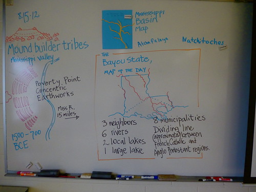
- 8 municipalities
- 6 rivers
- 2 local lakes
- neighbor states
- dividing line between the French Catholic cultural region and the Anglo Protestant region.
- seafood (it is the biggest producer of crawfish in the world, supplying approximately 90%), cotton, soybeans, cattle, sugarcane, poultry and eggs, dairy products, and rice.
- petro-chemical products.
- tourism.
Louisiana is classified as an impoverished state, ranking around 45th in the US in average income.
Educational standards are similarly low in ranking. Yet the state ranks high in health issues and rate of incarceration. Please see
http://www.hopenetworks.org/addiction/FactSheets/LA%20Problems.htm for sobering statistics on the Bayou States' issues, which include a slipping population.
Population: 4.5 million.
Shreveport
- I-20, I-49, Texas Trail (Hwy 80), Red River Parkways (Fant and Teague), Youree Dr, Line Ave, King's Hwy, Stoner Ave,
- East and West Shreveport
- city population 200,000 +
- metro pop. 470,000
- ethnic breakdown (2010 census)
59.48% White,
37.68% African American,
0.42% Native American,
0.74% Asian,
0.04% Pacific Islander,
0.54% from other races, and
1.09% from two or more races
1.82% Hispanic or Latino of any race
The median income for a household in the Metro area was $32,974, and the median income for a family was $39,203.
- Bossier City: 68,000.
