Learning the map of the UK via symbols
Magnet geography: the UK
Originally uploaded by trudeauSymbols may be effective learning tools, so allow me to suggest images that will connect with regions and the history of the UK.
- Northern Ireland: the HMS Titanic, which was built in the city of Belfast, N. Ireland.
- Ireland: The Guinness Book of World records - and a pint of black Guinness beer.
- Scotland: the green, cup, flag and driver used in a game of golf.
- England: the Rolls Royce, one of the great luxury cars.
- Wales: a British castle - built to control the rebellious Welsh forces.
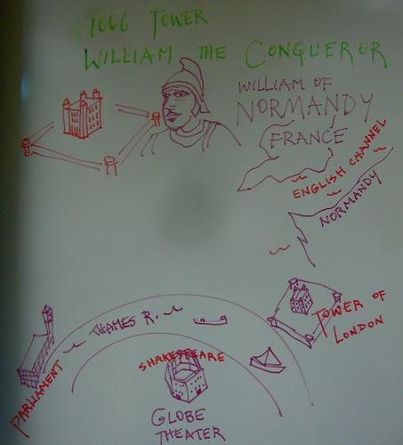
- France: the helmet-wearing William of Normandy, aka Wm the Conqueror.
- Belgium: french fries; the Belgians and Dutch probably preceded the French in frying potato strips, says Wikipedia.
- Netherlands: a bicycle, because they are so widely used as daily transportation in Holland.
-Germany: the Volkswagen Beetle, a revolutionary little car created by Dr. Ferdinand Porsche at the request of German Chancellor Adolph Hitler.
- Roman Empire: a large building that suggests a Public Bathhouse.
Throughout the empire the Romans built baths as they did amphitheaters and fortresses.
- The Romans called England "Britannia." They called Ireland "Hibernia."
- Anglo-Saxons: for the Germanic tribes who were the first Celtic peoples of England I offer a giant oak tree, which was a typical spot for Druid-led worship of these pre-Christian peoples.
- Latin language: Roman numerals. Also, the quote from Julius Caesar: "Veni, vidi, vici." "I came, I saw, I conquered."
- Roman Catholic Church: a Gothic cathedral.
- William of Normandy: the Tower of London, built by him in 1066.
- British Empire: a globe, because the British controlled lands all across the world. It was said, "The sun never sets on the British Empire."
For students and parents who love education and exploration of the social sciences . . .