The nations of what we call the Middle East are the principal topics of the first multi-media project in social studies class.
1. Iran
2. Iraq
3. Saudi Arabia
4. Israel (Palestine)
5. Lebanon
6. Syria
7. Turkey
8. Kuwait
9. Bahrain
10. Qatar
11. United Arab Emirates
12. Oman
13. Yemen
14. Jordan
15. Egypt
16. Holy cities of Mecca & Medina
17. Cairo
18. Baghdad
19. Tehran
20. Silk Road
Friday, August 31, 2007
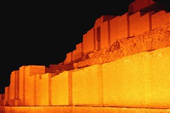
Topics for geo class presentations on Southwest Asia
Mesopotamia, land between the rivers
Sumeria, man's earliest beginnings
Tigris and Euphrates and Persian Gulf
Arabia, the mysterious peninsula
Mediterranean and Red Sea
Dhow and the Arab traders
Jewels of Persia
Biblical lands of Palestine

Sumeria, man's earliest beginnings
Tigris and Euphrates and Persian Gulf
Arabia, the mysterious peninsula
Mediterranean and Red Sea
Dhow and the Arab traders
Jewels of Persia
Biblical lands of Palestine
Thursday, August 30, 2007
Teach your parent(s) a lesson in the Mississippi valley / independent credit
Now that you've learned the states and about the engineering and the trade of this mondo valley, teach your parent a lesson in the Mississippi material.
Pretend to be Mr T. Make them use the atlas!
For independent credit, write an essay on the teaching experience. Include your parents' reactions and performance as well as how you felt communicating the material.

Pretend to be Mr T. Make them use the atlas!
For independent credit, write an essay on the teaching experience. Include your parents' reactions and performance as well as how you felt communicating the material.
Afghanistan: formerly home to the Taliban and al Qaeda
The mountainous, impoverished nation of Afghanistan remains a problem for the US. We used bombs and soldiers to get rid of the Taliban, the radical Muslim leadership group. The radical terrorist group called al Qaeda used this nation as HQ for training.
Subsequently we have tried to rebuild the nation. We have not been terrifically successful. Today, there are reports that the Taliban are again becoming a factor in Afghan life.

Subsequently we have tried to rebuild the nation. We have not been terrifically successful. Today, there are reports that the Taliban are again becoming a factor in Afghan life.
Saddam Hussein and Osama bin Laden; which is which?
Saddam and Osama.
Which one was a Saudi? Which one was a general? Which one lived in Afghanistan? Which one has enormous wealth?
Briefly,
Saddam Hussein
- murderous military dictator of Iraq.
- kept the peace between the Sunnis and Shiites in Iraq.
- tried and executed by the Iraqis for mass murder.
- threatened the US by refusing to allow weapons inspections.
- began his conflict with the US and other nations in 1991 by taking over the tiny but oil-rich nation of Kuwait.
Osama bin Laden
- born to wealthy family in Saudi Arabia.
- became a strict, conservative Muslim.
- fought in with the Afghanis against the invading Russians (then the Soviet Union).
- helped build the radical organization called al Qaeda.
- al Qaeda trained anti-Western terrorists in Afghanistan.
- the US believes the 9/11 plan was initiated by Osama.
Wednesday, August 29, 2007
Wheat: basic foodstuff of mankind / domesticated in SW Asia
Today I passed out bits of wheat flat bread, one of mankind's oldest snacks. It was, in effect, Biblical bread.
It is symbolic of our study of the Middle East.
When was wheat domesticated? That means when was it cultivated and harvested as opposed to simply gathered from the wild?
What was it about the domesticatrion of wheat that led to the rise of cities and laws?

It is symbolic of our study of the Middle East.
When was wheat domesticated? That means when was it cultivated and harvested as opposed to simply gathered from the wild?
What was it about the domesticatrion of wheat that led to the rise of cities and laws?
How cajuns differ from New Orleanians - in the stereotypes
While oversimplifications can be tricky, I feel comfortable with stating these as differences between the history of the Cajun and the New Orleanian.
Cajuns went from France to Nova Scotia (Acadia) to Louisiana.
Frenchmen arrived in New Orleans before the Acadians came to La.
There were arguably more Spanish and more African peoples in NO.
Cajun dancing (circle dance) and cooking (boudin) was simple. It was what we call folk art.
NO dancing (quadrille) and cooking (etouffee) were more complex.
Mardi Gras in New Orleans was like that of Paris. The Cajuns celebrated as country people, the courrir de Mardi Gras.
From Canada to the Gulf: the Miss. valley
Among the early European travelers of the Mississippi valley were the French traders known as courieurs de bois, "runners of the wood."
They were living among the indigenous peoples, or the natives. In a word, they lived with the Indians. Many of these French explorer / traders married aborigine, or indigenous, women.
The aboriginal people of North La were the Caddo. Today the remaining Caddo mostly live in Oklahoma.
My French-Canadian family came from the area around Quebec. Some of the Trudeaus went down the St lawrence River and connected with the Miss valley. They found their way to Natchitoches and New Orleans. My particular branch went as far as Massachusetts.
The study of family history? Genealogy.
Tuesday, August 28, 2007
Independent writing: watch Nova, PBS, on Tues, Aug 28, on Katrina

Finding the Way Home: Two Years After Katrina by Brenda Ann Kenneally
Originally uploaded by MediaStorm
It is followed at 8 by Surviving the Storm, about the efforts of medical personnel at Ochsner Hospital in New Orleans during Hurricane Katrina.
Independent, bonus credit: Write an essay comparing what we learned from the John Barry essay, "Pittsburgh cabbie," with what you hear on "Surviving the Storm."
Tuesday: Tiw, or Tyr, the God of War
We're gradually researching the background of the names of the days of the week.
The name comes from Middle English Twisday, from Old English Tiwes dæg, named after the Nordic god Tyr, who was the equivalent of the Roman war god Mars, says wikipedia.
Thus we see a similarity between Tues and Thurs, Thor's Day.
And a contrast with Friday, yes?
The name comes from Middle English Twisday, from Old English Tiwes dæg, named after the Nordic god Tyr, who was the equivalent of the Roman war god Mars, says wikipedia.
Thus we see a similarity between Tues and Thurs, Thor's Day.
And a contrast with Friday, yes?
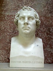
Martin Luther and Henry VIII: leaders of the Protestant reformation
Is your family associated with a Protestant denomination? Most likely, yes. In North La the average person is Protestant in background.
Protestant is a category of Christian denominations based on the word "protest."
Martin Luther was a German monk, priest, professor, theologian, and church reformer. His teachings inspired the Reformation, and influenced the doctrines and culture of the Lutheran and Protestant traditions, and the course of Western civilization. His protest was against several forms of corruption in the Catholic church.
Henry VIII, the English king who disagreed with the Catholic Church over the issue of divorce, was also a Protestant. Henry established the Church of England, a Christian church like the Catholic church except in the policy on divorce.
Today the principal Protestant groups include:
Methodist
Baptist
Church of God
Lutheran (Martin Luther-based)
Episcopalian
Presbyterian
Monday, August 27, 2007
Independent work: visit Meadows Museum, Centenary College and write about what you learn
Meadows Museum currently has an exhibit of Katrina-related photos and art of New Orleans. It makes a great resource center for geo class.
Go see it, explore the museum and write about it for independent credit.
While you're there, visit the Centenary campus. It is an attractive area and may be part of your future.
* Haynes Exercise center
* The shell, or Greek theater
* Student center
* Crumbly Gardens
Go see it, explore the museum and write about it for independent credit.
While you're there, visit the Centenary campus. It is an attractive area and may be part of your future.
* Haynes Exercise center
* The shell, or Greek theater
* Student center
* Crumbly Gardens
Minneapolis to New Orleans: memorize the map of 10 Mississippi valley states for a quiz Thursday
Last week's test was on reading comprehension and composition. This week the quiz will call upon memorization. Students will pracice this map each day in class. It's worth 20 pts.
* Sketch - by hand - a map of the 10 states that border the Miss R.
* Add the names of 5 major cities (Minneapolis, St Louis, memphis, BR and NO).
* You will get a point for each state (spelling counts) and each city. You will get 5 pts for sketching the states' borders correctly.
In this class we will use the metropolitan population in our demographic notes on cities. In the RMQRWA, the metropolitan number is the one in parentheses.
The metro population of Baton Rouge almost dobled after Katrina, from about 400,000 to 700,000 (correcting my class notes).
Post-Katrina New Orleans has lost about half its population. The city itself was about 400,000, pre-storm. It is perhaps 200,000 today, says wikipedia.org. The Metro area has rebounded to some 1.2 M, down from 1.4 M pre-storm, says the Census Bureau.
Which is the city with the most people on the Miss R?
vocabulary:
proximate (Not approximate)
Parents must sign first test papers and return them to Mr. Trudeau
Parents are required to sign and send back to me the first test. This evaluation represents a beginning point in a progression of skill development.
The first test was diagnostic and focused mainly on -
* reading comprehension
* possession and use of of the class notes (an open notes test)
* careful reading
The essay spotlighted -
* reading comprehension
* logic and detail in composition
* grammar and spelling
From these relatively brief tests we can see the challenge ahead. They show each student - and parents - the areas that call for development as well as strengths.
Independent work is an alternate way to build points and show intellectual growth. Independent paper topics will be given on this site each week. They are comaprison essays, each a bit unexpected in its juxtaposition of topics.
Sunday, August 26, 2007
Symbols for quick feedback on geography class essays
Trudeau's system for marking your essays involves the following shorthand items:
Star: excellent; highest praise.
Check: quite good; competent and point-earning material. Large check, more credit. Small check, less credit.
Wavy line: material not at an acceptable level; look for errors in either grammar and construction or in accuracy of information.
Circle: spelling, agreement or punctuation error.
Size of the mark generally denotes greater or lesser praise or caution.
If the mark is not sufficiently clear to you after reading over the passage, please see me. When possible I will respond during class. Sometimes it will have to be after class. Before and after school are also good times to ask questions of me.
Honor roll on the first essay and test in high school social studies
Honored students in the first evaluation in high school social studies:
1st hour, 18 or better on the multiple choice:
Samni Adegboyega
Morgan Emmons
Tyler Rash
Kaitlyn Stephens
1st hour, 5 out of 5 on the essay:
Samni Adegboyega
Dominique Banks
Codi Cummings
Brian Day
Kacie Dzenowski
Matthew Giglio
Adrienne Palmer
Yusheng Qin
Hannah Shuflin
Kaitlyn Stevens
Monica White
Samantha Wren
2nd hr, mult-choice:
Bitsy Hamiter
Emily McGowan
Alexis Mongold
Chas DeNeal
2nd hr, essay:
Emma Claire Hughes
Brett Kessel
Will Singleton
Jay Theriot
Charlotte Willcox
Chas DeNeal
Daniel McFarland
3rd hr, essay:
Elizabeth Smith
Sarah Nichols
Daniel Jordan
Chris Hudson
Neha Dhawan
Rocio Cortez
Sh'derrica Abner
Shelley Whitaker
Octavis Johnson
Paul O'Young
Katelyn Jaudon
Ernesto Diaz
Ashley Sims
Avalon Holloway
5th hr, mult-choice:
Rebecca Elder
Joseph Reynolds
Karen Ezelle
Emily Palmer
5th hr, essay:
Jonathan Cosme
Lakyn Smith
Mary Ainsworth
Karen Ezelle
Jarret Atkins
Emily Palmer
6th hr, essay:
Lindsey Trombetta
Juliana Burnell
Emma Viskozki
Michael Nguyen
Jinan Halim
Alison Mitchell
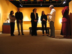
The illustration above shows students writing their essays in a school in south central Asia.

1st hour, 18 or better on the multiple choice:
Samni Adegboyega
Morgan Emmons
Tyler Rash
Kaitlyn Stephens
1st hour, 5 out of 5 on the essay:
Samni Adegboyega
Dominique Banks
Codi Cummings
Brian Day
Kacie Dzenowski
Matthew Giglio
Adrienne Palmer
Yusheng Qin
Hannah Shuflin
Kaitlyn Stevens
Monica White
Samantha Wren
2nd hr, mult-choice:
Bitsy Hamiter
Emily McGowan
Alexis Mongold
Chas DeNeal
2nd hr, essay:
Emma Claire Hughes
Brett Kessel
Will Singleton
Jay Theriot
Charlotte Willcox
Chas DeNeal
Daniel McFarland
3rd hr, essay:
Elizabeth Smith
Sarah Nichols
Daniel Jordan
Chris Hudson
Neha Dhawan
Rocio Cortez
Sh'derrica Abner
Shelley Whitaker
Octavis Johnson
Paul O'Young
Katelyn Jaudon
Ernesto Diaz
Ashley Sims
Avalon Holloway
5th hr, mult-choice:
Rebecca Elder
Joseph Reynolds
Karen Ezelle
Emily Palmer
5th hr, essay:
Jonathan Cosme
Lakyn Smith
Mary Ainsworth
Karen Ezelle
Jarret Atkins
Emily Palmer
6th hr, essay:
Lindsey Trombetta
Juliana Burnell
Emma Viskozki
Michael Nguyen
Jinan Halim
Alison Mitchell
The illustration above shows students writing their essays in a school in south central Asia.
Week of Aug 27: intro to Southwest Asia
You know this region as the Middle East. A less ethnocentric term is Southwest Asia.
Ethnocentrism is one of the themes of geo class.
This week -
Mon.
Review of New Orleans, the river and coastal erosion. Hands-on project. Review for hand-sketched map quiz on Thurs.
Tues.
Intro to SW Asia, aka Petrolia.
Importance of the region to the world.
Strengths.
Difficulties.
Wed.
Intro to Islam.
The Five Pillars.
Thurs.
Map quiz on the Mississippi valley: 15 items.
- Quiz will comprise a sketch of the states and a selection of cities that immediately touch upon the Miss R.
- Mn, Wi, Io, Il, Mo, Ky, Tn, Ar, Ms, La
- Minneapolis, St Louis, Memphis, Baton Rouge, New Orleans
- scored on accuracy of placement and proportion (I only expect an approximation) and spelling of all items (no abbreviations of major names).
Fri. SW Asia research project.
- Librarians intro resources and software for project.
- Topics assigned.
- Use flashdrives to save material. Or email it to yourself.
- 5-day project.
Friday, August 24, 2007
An important book, if a quick read: Fahrenheit 451
ray Bradbury's sci-fi novel fahrenheit 451 remains one of the most important books of the era. Please plan to read it.

Norse goddess Freya gives us freyday or fridae or frige doeg
From the Old English, Frige Doeg, and from the Old High German, Fria Tag,we see the roots of Friday.
Do we live in a male-centric society? Does the fact that the median male income in Spt is $31,000 and the female median income is $21,000 offer evidence?
Despite the feminist movement I contend that US society remains old-fashioned and male-dominant.
That's why you rarely celebrate or even hear about the Norse (north) goddess of fertility and love, Freya (Fria).
Map of New Orleans flooding from Hurricane Katrina
Students sketched a map of the Crecent City (crescent bend in the river) that included the following:
- French Quarter / Vieux Carre ("old section")
- Uptown neighborhood / affluence and mansions along St Charles Ave.
- Univeristy section: Tulane, Loyola U, Xavier U.
- Superdome
- Metairie
- Lake Pontchartrain
- Univ of NO
- Industrial canal (ship channel)
- 9th ward
- St Bernard parish
- West Bank area
- Slidel (across L. Pontchartrain)
Times-Picayune slide show.
picayune - something of little value / a penny coin.
Thursday, August 23, 2007
Green Day lyrics on the flood and loss of New Orleans
"The Saints Are Coming"
[The Skids Cover]
There is a house in New Orleans, they call the Rising Sun
It's been the ruin of many a poor boy, and God, I know I'm one.
I cried to my daddy on the telephone,
how long now?
Until the clouds unroll and you come home,
the line went.
But the shadows still remain since your descent,
your descent.
I cried to my daddy on the telephone,
how long now?
Until the clouds unroll and you come home,
the line went.
But the shadows still remain since your descent,
your descent.
The saints are coming, the saints are coming.
I say no matter how I try, I realise there's no reply.
The saints are coming, the saints are coming.
I say no matter how I try, I realise there's no reply.
A drowning sorrow floods the deepest grief,
how long now?
Until the weather change condemns belief,
how long now?
When the night watchman lets in the thief
Whats wrong now?
The saints are coming, the saints are coming
I say no matter how I try, I realise there's no reply.
The saints are coming, the saints are coming
I say no matter how I try, I realise there's no reply.
I say no matter how I try, I realise there's no reply.
I say no matter how I try, I realise there's no reply.
Thanks to surferchick70, aka Aouicha, for the lyrics.
Memorex Mini Flash Drive at Office Depot for $7, says a student
A 256 mb Memorex flash drive was purchased by one of my students at Office Depot for $7. Great deal.

Test session guidelines for geo class
Test taking is not easy for some first-years because of their general impatience with academic work. To be successful I have observed that students must ...
* Slow down and read questions carefully.
* Go back and check answers.
* When there are several answers that seem to be correct, be able to choose the one that is more directly true.
Classroom guidelines ...
* On open-notes tests, you may use a print-out from the web site, your in-class notes, your atlas, textbook and a dictionary.
* No communication between students during the test.
- no whispering, even if on a non-cheating sort of question.
- no passing of notes or other materials.
* raise your hand when you have a question of any sort. It will be answered by your teacher - in a whisper.
Penalty for ignoring guidelines: phone call to parent; point penalty.
On tests ...
* legibility.
* grammar and spelling.
* use examples in writing essays.
Wednesday, August 22, 2007
Parents are invited to Robert Trudeau's brown bag lunches at CMHS
In order to better serve parents' needs I have several open lunch meetings in the fall for parents who'd like to know more about the geography class, CMHS, college and their children.
The lunch get togethers are on Friday, from 12 to 1 pm. Although an advance email (trudeau@earthlink.net) or call (861-6809 h, 221-2501, w) would be helpful, if you cannot, just drop in.
That's upstairs in the new wing, E 205. Noon to 1 is my planning period and a great time to talk about your child's future.
We'll have one next Fri, too.
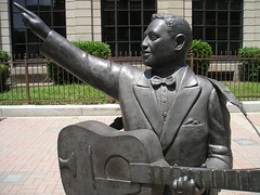
Clubs at Magnet: why we have a Leadbelly Society
Leadbelly Society is one of many clubs that met during activity period Wed, Aug 22.
At Magnet I sponsored the Writer's Club for years and years. Then we changed its name to Leadbelly Society and decided to integrate music and writing (and other media).
Today at the first 07-08 meeting I played and sang Leadbelly tunes like "Goodnight, Irene," "Midnight Special" and "Rock Island Line." Huddie Ledbetter, (1888 - 1949) was made famous by the tunes he gave to the world. Also performing were students Brett Havener, Andrew Wood and Brian Day.
More facts about Ledbetter, aka the "father of American Folk music," and "King of the 12-string guitar:"
* spent years in prison for murder and felonious assault.
* "sang his way out of prison" in Tx by a song he wrote for the governor.
* was discovered by folklorist (trained to collect and publish folk songs, art, tales, dance,m etc) Alan Lomax, of the U of Texas and the Library of Congress (Wash, DC).
* Lomax recorded Lead at Angola State Prison.
* Lomax presented the singer to the media in NYC in 1935. Leadbelly became known through records and newsreels.
* Leadbelly lived in NYC and performed in coffeehouses, colleges and schools and at political rallies.
* Buried at Shiloh Baptist Church near Mooringsport. People from all over the world stop at his gravesite to pay respects.
Tuesday, August 21, 2007
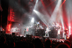
Linkin Park references the flood on their new album
Sarah Nichols pointed out to me that one of the songs on the new Linkin Park album is pointedly about a flood like Katrina in addition to a personal relationship. It's a very listenable tune and now I have a copy of it. I asked her to send me the lyrics:
Linkin Park- The Little Things Give You Away
water grey
through the windows
up the stairs
chilling rain
like an ocean
everywhere
don't want to reach for me do you
i mean nothing to you
the little things give you away
and now there will be no mistaking
the levees are breaking
all you've ever wanted
was someone to truly look up to you
and six feet / under water
i do
hope decays
generations disappear
washed away
as a nation simply stares
dont want to reach for me do you
i mean nothing to you
the little things give you away
and now there will be no mistaking
the levees are breaking
all you've ever wanted
was someone to truly look up to you
and six feet / underwater
i do
all you've ever wanted
was someone to truly look up to you
and six feet / underground
i do...
Aug 31 geo classes will begin a week-long research project in the library and need a flash drive
The Middle East / Southwest Asia unit will unfold with studies of nations in the library. Today as I planned the unit with the librarians they reminded me that students should be highly encouraged to use flash drives to save their work each day.
Floppy disks and CD's have proven frustrating, reminded Mrs. Kay Gammill and Mrs. Lorna White.
Neither the size nor brand of the flash drive matter. Old ones work as well as new ones, in my experience. One thing I'd like to request: keep the lanyard attached to the tiny device. It helps prevent accidental loss.
Questions? Ask in class or look it up. Wikipedia has an effective explanation of how the flash drive works.
What to print out for the quiz Thurs
Scroll back to Aug 13, please.
To get to Aug 13, you may have to go to the left toolbar to find the Archives. Click on Aug, 07. Print out these articles . . .
1) Welcome to Magnet
2) Demographics
3) Just in Time supply
4) Presentations
5) La Coastline Notes (No questions on the Geo class syllabus)
Copies of "Pittsburgh cabbie ..." are available in the classroom.
6) Einstein
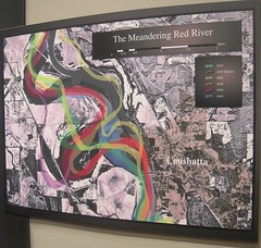
7) Red River story
8) Affluent suburbia
9) Notes, Tues, Aug 21.
Bonus credit:
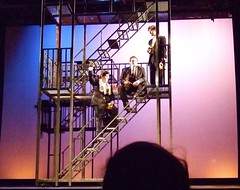
Typed essay on the geography behind "Romeo & Juliet" or "Taming of the Shrew," currently being produced by Centenary College.
To get to Aug 13, you may have to go to the left toolbar to find the Archives. Click on Aug, 07. Print out these articles . . .
1) Welcome to Magnet
2) Demographics
3) Just in Time supply
4) Presentations
5) La Coastline Notes (No questions on the Geo class syllabus)
Copies of "Pittsburgh cabbie ..." are available in the classroom.
6) Einstein
7) Red River story
8) Affluent suburbia
9) Notes, Tues, Aug 21.
Bonus credit:
Typed essay on the geography behind "Romeo & Juliet" or "Taming of the Shrew," currently being produced by Centenary College.
Notes, Tues, Aug 21: the Miss R valley
Name the river associated with . . .
- Kansas City - Missouri R.
- Cincinatti - Ohio R.
- Pittsbugh - Ohio R.
- Tulsa - Arkansas R.
These are among the great tributaries of the Miss valley.
John Barry's point is that numerous US cities benefit from the Miss R. through trade.
Define:
- meandering
- saline
- ox bow lake
- jetty
- levee
- sediment
- Bienvenue en Louisiane
- gazeteer - compilation of locations; like a dictionary of places.
Monday, August 20, 2007
World War II: a multimedia contest for students and teachers from LPB
To accompany the airing of Ken Burns series on World War II, there is a contest for students asking for multi-media projects.
Choose -
Powerpoint
Video
Audio
or combinations thereof.
No more than 3 mins length.
See more at LPB.

Choose -
Powerpoint
Video
Audio
or combinations thereof.
No more than 3 mins length.
See more at LPB.
Affluent suburbia . . .
Most of the students at CMHS come from affluent suburbia, which means well-to-do and not in the downtown area.
If you live downtown, you're an urbanite.
Urban: having to do with cities.
Suburban: a gas-intensive, truck-like commuter vehicle.

If you live downtown, you're an urbanite.
Urban: having to do with cities.
Suburban: a gas-intensive, truck-like commuter vehicle.
Red River Story
Notes upon the background of Louisiana's Red River -
- tributaries in N. Mexico.
- Canyon, TX (Panhandle), the Prairie Dog Red River
- border between TX and OK
- loops thru AR
- does not flow through downtown Natchitoches.
- flows through Alexandria.
- meets the Miss R near the line 31 degree parallel.
1861 - 1865 - US Civil War
mnemonic - memory aid
Ft Humbug on the bluffs at the Va Hospital. Union Army tries to capture Spt in waning months of war. Stopped by the CSA at Battle of Mansfield.
Sunday, August 19, 2007
Activities that illustrate Barry's hypothesis in "Pittsbugh cabbie"
1. Map of the Gulf coastal plain showing a triangular area from Cape Girardeau, MO, to Texas and Ala.
Wavelines show former extent of the Gulf.
Shark’s teeth found in Miss. are evidence.
2. Sketch of trees and dirt collapsing into the river channel.
3. Sketch shows concrete panels being used on the river channel sides and bottom to make a canal-like waterway. Label sediment being trapped and not allowed to flow into the river. Label: River deprived of 60% of its former sediment load.
4. Sketch map that shows Tulsa, KC, Minneapolis, Cincinatti and Pittsburgh. Show the rivers that connect to the Miss valley.
Label: 20% of US exports. 60% of grain exports. NO is busiest port.
5. Sketch of the Miss delta at the mouth of the river. Label: jetties ectend 2 miles into Gulf. Sediment is deposited off the continental shelf.
6. Sketch map of La and Miss that shows levees preventing alluvial soil from being distributed across the cotton and soybean fields.
7. Sketch coastal La. showing I-10 and the marshes. Sketch fine lines that penetrate the coast line and go to well heads (a square - in reality it looks like a steel valve with a giant steel valve control wheel atop it.)
Label: 10,000 miles of canals service oil and gas wells. Label: arrows show saltwater going up the canals to cripple the marshland. Label: 2,100 square miles of coastal land and barrier islands have melted into the Gulf of Mexico.
8. Sketch US outline map. Label: The nation as a whole gets nearly all the benefits of engineering the river. Louisiana and some of coastal Mississippi get 100 percent of the costs. Why should a cab driver in Pittsburgh or Tulsa pay to fix Louisiana's coast? Because he gets a stronger economy and lower energy costs from it, and because his benefits created the problem.
9. Map of New Orleans:
* French Quarter (grid)
* Uptown (upriver): Tulane, Loyola, Xavier, Audubon Park.
* Downtown: the Central Business District. Canal St.
* Lakefront: UNO, canals.
* Ship Channel that connects L. Pontchartrain w Miss R.
* Lower 9th ward.
* St Bernard Parish.
* Areas of higher elevation near rim of “bowl.”
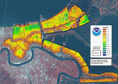
Understanding the Mississippi River, New Orleans and coastal land loss; week of Aug 20 - 24

New Orleans, LA--Aerial views of damage caused from Hurricane Katrina the day after the hurricane hit August 30, 2005. Photo by Jocelyn Augustino/FEMA
Originally uploaded by greenmannowar
- understanding geographic landscapes and how they are affected by geological history (ex, the growth and loss of the Gulf coastal plain).
- improving note-taking by
* using key fragments and abbreviations.
* using symbols and sketches in order to better visualize the material.
We will complete a reading of and notes on the
1) John Barry / Washington Post article and
2) begin a reading of the Michael Grunewald / Time magazine article.
Thurs, Aug 20: first quiz. See earlier post.
Fri: hands-on model of the riverine landscape.
Saturday, August 18, 2007
Melding a student body from a multitude of middle schools
Most of the 24 middle schools represented in my students:
youree
southfield
st johns
st joseph
keithville
montessori
elm grove
green acres
n desoto
st marks
herndon
calvary
first baptist
turner
linwood
bethune
evangel
broadmoor
christian center montessori
st marks
js clark
home schooled
bickham

youree
southfield
st johns
st joseph
keithville
montessori
elm grove
green acres
n desoto
st marks
herndon
calvary
first baptist
turner
linwood
bethune
evangel
broadmoor
christian center montessori
st marks
js clark
home schooled
bickham
Friday, August 17, 2007
Einstein, the physicist adept at visualization

Albert Einstein
The Nobel Prize in Physics 1921
Biography
Albert Einstein was born at Ulm, in Württemberg, Germany, on March 14, 1879, says nobelprize.org. Six weeks later the family moved to Munich and he began his schooling there at the Luitpold Gymnasium.
Later, they moved to Italy and Albert continued his education at Aarau, Switzerland and in 1896 he entered the Swiss Federal Polytechnic School in Zurich to be trained as a teacher in physics and mathematics. In 1901, the year he gained his diploma, he acquired Swiss citizenship and, as he was unable to find a teaching post, he accepted a position as technical assistant in the Swiss Patent Office. In 1905 he obtained his doctor's degree.
During his stay at the Patent Office, and in his spare time, he produced much of his remarkable work and in 1908 he was appointed Privatdozent in Berne. In 1909 he became Professor Extraordinary at Zurich, in 1911 Professor of Theoretical Physics at Prague, returning to Zurich in the following year to fill a similar post. In 1914 he was appointed Director of the Kaiser Wilhelm Physical Institute and Professor in the University of Berlin. He became a German citizen in 1914 and remained in Berlin until 1933 when he renounced his citizenship for political reasons and emigrated to America to take the position of Professor of Theoretical Physics at Princeton*. He became a United States citizen in 1940 and retired from his post in 1945.
After World War II, Einstein was a leading figure in the World Government Movement, he was offered the Presidency of the State of Israel, which he declined, and he collaborated with Dr. Chaim Weizmann in establishing the Hebrew University of Jerusalem.
Einstein always appeared to have a clear view of the problems of physics and the determination to solve them. He had a strategy of his own and was able to visualize the main stages on the way to his goal. He regarded his major achievements as mere stepping-stones for the next advance.
At the start of his scientific work, Einstein realized the inadequacies of Newtonian mechanics and his special theory of relativity stemmed from an attempt to reconcile the laws of mechanics with the laws of the electromagnetic field. He dealt with classical problems of statistical mechanics and problems in which they were merged with quantum theory: this led to an explanation of the Brownian movement of molecules. He investigated the thermal properties of light with a low radiation density and his observations laid the foundation of the photon theory of light.
In his early days in Berlin, Einstein postulated that the correct interpretation of the special theory of relativity must also furnish a theory of gravitation and in 1916 he published his paper on the general theory of relativity. During this time he also contributed to the problems of the theory of radiation and statistical mechanics.
In the 1920's, Einstein embarked on the construction of unified field theories, although he continued to work on the probabilistic interpretation of quantum theory, and he persevered with this work in America. He contributed to statistical mechanics by his development of the quantum theory of a monatomic gas and he has also accomplished valuable work in connection with atomic transition probabilities and relativistic cosmology.
After his retirement he continued to work towards the unification of the basic concepts of physics, taking the opposite approach, geometrisation, to the majority of physicists.
Einstein's researches are, of course, well chronicled and his more important works include Special Theory of Relativity (1905), Relativity (English translations, 1920 and 1950), General Theory of Relativity (1916), Investigations on Theory of Brownian Movement (1926), and The Evolution of Physics (1938). Among his non-scientific works, About Zionism (1930), Why War? (1933), My Philosophy (1934), and Out of My Later Years (1950) are perhaps the most important.
Albert Einstein received honorary doctorate degrees in science, medicine and philosophy from many European and American universities. During the 1920's he lectured in Europe, America and the Far East and he was awarded Fellowships or Memberships of all the leading scientific academies throughout the world. He gained numerous awards in recognition of his work, including the Copley Medal of the Royal Society of London in 1925, and the Franklin Medal of the Franklin Institute in 1935.
Einstein's gifts inevitably resulted in his dwelling much in intellectual solitude and, for relaxation, music played an important part in his life. He married Mileva Maric in 1903 and they had a daughter and two sons; their marriage was dissolved in 1919 and in the same year he married his cousin, Elsa Löwenthal, who died in 1936. He died on April 18, 1955 at Princeton, New Jersey.
Thursday, August 16, 2007
John Barry article for Washington Post: "Pittsburgh cabbie has stake in saving La's coastline"
Pittsburgh cabbie has a stake in saving La.'s coast / John Barry
May 12 Washington Post.
John M. Barry is the author of the book Rising Tide, an award-winning
examination of the Miss. flood of 1927.
There has been much debate in the past 20 months over protecting Louisiana from another lethal hurricane, but nearly all of it has been conducted without any real understanding of the geological context. Congress and the Bush administration need to recognize six facts that define the national interest.
Fact 1: The Gulf of Mexico once reached north to Cape Girardeau, Mo. But the Mississippi River carries such an enormous sediment load that, combined with a falling sea level, it deposited enough sediment to create 35,000 square miles of land from Cape Girardeau to the present mouth of the river.
This river-created land includes the entire coast, complete with barrier islands, stretching from Mississippi to Texas. But four human interventions have interfered with this natural process; three of them that benefit the rest of the country have dramatically increased the hurricane threat to the Gulf Coast.
Fact 2: Acres of riverbank at a time used to collapse into the river system providing a main source of sediment. To prevent this and to protect lives and property, engineers stopped such collapses by paving hundreds of miles of the river with riprap and even concrete, beginning more than 1,000 miles upriver — including on the Ohio, Missouri and other tributaries — from New Orleans. Reservoirs for flood protection also impound sediment. These and other actions deprive the Mississippi of 60 to 70 percent of its natural sediment load, starving the coast.
Fact 3: To stop sandbars from blocking shipping at the mouth of the Mississippi, engineers built jetties extending more than two miles out into the Gulf of Mexico. This engineering makes Tulsa, Kansas City, Minneapolis, Cincinnati, Pittsburgh and other cities into ports with direct access to the ocean, greatly enhancing the nation's economy. The river carries 20 percent of the nation's exports, including 60 percent of its grain exports, and the river at New Orleans is the busiest port in the world. But the jetties prevent any of the sediment remaining in the river from replenishing the Louisiana and Mississippi coasts and barrier islands; instead, the jetties drop the sediment off the continental shelf.
Fact 4: Levees that prevent river flooding in Louisiana and Mississippi interfere with the replenishment of the land locally as well.
Fact 5: Roughly 30 percent of the country's domestic oil and gas production comes from offshore Louisiana, and to service that production the industry created more than 10,000 miles of canals and pipelines through the marsh.
Every inch of those 10,000-plus miles lets saltwater penetrate, and eat away at, the coast. So energy production has enormously accelerated what was a slow degradation, transforming a long-term problem into an immediate crisis. The deprivation of sediment is like moving a block of ice from the freezer to the sink, where it begins to melt; the effect of the canals and pipelines is like attacking that ice with an ice pick, breaking it up.
As a result, 2,100 square miles of coastal land and barrier islands have melted into the Gulf of Mexico. This land once served as a buffer between the ocean and populated areas in Louisiana and part of Mississippi, protecting them during hurricanes. Each land mile over which a hurricane travels absorbs roughly a foot of storm surge.
The nation as a whole gets nearly all the benefits of engineering the river. Louisiana and some of coastal Mississippi get 100 percent of the costs. Eastern New Orleans (including the lower 9th Ward) and St. Bernard Parish — nearly all of which, incidentally, is at or above sea level — exemplify this allocation of costs and benefits. Three man-made shipping canals pass through them, creating almost no jobs there but benefiting commerce throughout the country. Yet nearly all the 175,000 people living there saw their homes flooded not because of any natural vulnerability but because of levee breaks. These levee breaks were along these three man-made shipping canals.
Fact 6: Without action, land loss will continue, and it will increasingly jeopardize populated areas, the port system and energy production. This would be catastrophic for America. Scientists say the problem can be solved, even with rising sea levels, but that we have only a decade to begin addressing it in a serious way or the damage may be irreversible.
Despite all this and President Bush's pledge from New Orleans in September 2005 that "we will do what it takes" to help people rebuild, a draft White House cuts its own recommendation of $2 billion for coastal restoration to $1 billion while calling for an increase in the state's contribution from the usual 35 percent to 50 percent. This turns the idea of the Union on its head. Generating benefits to the nation is what created the problem, and the nation needs to solve it. Put simply: Why should a cab driver in Pittsburgh or Tulsa pay to fix Louisiana's coast? Because he gets a stronger economy and lower energy costs from it, and because his benefits created the problem.
The failure of Congress and the president to act aggressively to repair the coastline at the mouth of the Mississippi River could threaten the economic vitality of the nation. Louisiana, one of the poorest states, can no longer afford to underwrite benefits for the rest of the nation.
La coastline notes, Th, Aug 16
John Barry article for Washington Post: "Pittsburgh cabbie has stake in saving La's coast"
Note-taking skills:
* Do not write complete sentences. Write key statements in brief fragments.
* Leave spaces between notes.
* Write down words new to you.
* Use appropriate sketches and symbols.
Allons a Lafayette ("Let's go to Lafayette," in French)
Make an informal sketch map of La and its neighbors.
- Rim of color around borders and along rivers.
- Identify 5 municipalities.
- Why begin a study of World bGeography with little Louisiana?
one answer: Katrina and its aftermath.
The Death Dance of Katrina:
1. African coast.
2. Atlantic
3. Along the equator across the Atlantic.
4. Enters the Caribbean.
5. Moves into the Gulf of Mexico.
6. Builds strength by encicrcling a node of warm water in the gulf.
7. Smashes into the La. coastline as Category 3 storm.
8. Levees do not hold. Why not?
Media discussion:
niche media - specialty sources of news, not in widespread use. Ex, Myspace or PBS or AM Talk Radio.
Americans no longer have a shared national source of news and perspective. The daily Times is no longer read on a near-universal basis.
World geography syllabus and working schedule
World Geography syllabus / Robert Trudeau
"Participation is the key."
Semester One
Introduction to Social Studies & CMHS 1 week
Louisiana coastline & New Orleans 1 week
China & Japan: Big changes in East Asia 5 weeks
Vietnam & Thailand: Remembering the Vietnam Conflict 1 week
India & Mohandas Gandhi: Ancient traditions, Modern upheavals 3 weeks
Saudi Arabia & the Persian Gulf: Arab history, Global oil 3 weeks
Israel & the Middle East: Conflict from the Biblical to the Modern 4 weeks
Semester Two
New York City & Los Angeles: Megalopoli 2 weeks
West Africa / Senegal to Angola: Part of America's Roots 3 weeks
Golden Age in Greece: Democracy & Philosophy 3 weeks
Roman Empire & Italy: Technology & Christianity 3 weeks
France: Kings & Cuisine 2 weeks
England: Language & Government 2 weeks
Geography is a social studies regimen in which students take a humanities approach appropriate to a college-oriented high school curriculum. The class integrates
* study of language (especially Greek and Latin roots)
* literature (often through classic films such as Gandhi)
* architecture (students make abbreviated models of buildings such as the Taj Mahal and the Great Mosque at Mecca)
* cuisine (taste this Japanese nori, or cultivated seaweed, and write down 5 sensory words)
* music (ethnic or classical music is played in the classroom daily)
* map study (students can draw and label a map comprising the entire world by year's end), * economy (per capita income, standard of living) and
* history (kings & queens, empires, wars).
Subject-matter units may vary in order and substitutions may occur according to world conditions.
Skills emphasized in geography class comprise the higher thinking modes: analysis, synthesis, evaluation, composition and questioning. The primary theme is that students are encouraged to gather information about a nation / culture and compare it to previously-studied nations.
Analysis: to take apart the elements of a culture:
* land - ex., from the cold Himalayas to bustling Shanghai
* resources - petroleum, alumina, arable land, work ethic
* history - golden eras, wars, colonialization, empire
* arts - architecture, painting, sculpture, literature, clothing
* philosophy - What is the theme of Confucianism? can you identify the difference between Buddhism and Taoism?
* government - authoritarian, socialist, democratic
* economy - free enterprise, government controlled, modified
* ethnic groups - Mongolian, Chinese, Japanese, Korean, Creole
* language - Latin, Greek, Sanskrit, Hindi, Mandarin Chinese
* religions - the degrees of fervor in Christian, jewish and Muslim communities
Synthesis: combine elements of cultures to offer a theme or thesis.
Ex., a) Write a brief essay showing the similarities in Chinese and American cultures. b) Create an annotated map that shows the influence of Buddhism across several nations in Asia.
Questions which accompany each class activity emphasize interpretation and comparison.
Ex.: if most of the world's poor population cooks over charcoal, what are the indirect stresses on the environment? answer: not only air pollution, but deforestation (charcoal being the product of partially burned trees). Deforestation leads to excessive erosion of topsoil and to an extreme danger: a decline in agricultural production.
Learning styles exploration and communication styles evaluation are the subtext for this social studies class.
* How effective is repetition? How can repetition be made bearable?
* How does art - ex., illustrations - enhance learning? Does color add significant impact to communication?
* Does a hands-on activity (for instance, a puzzle map) enhance retention of material?
* Does a multiple-choice quiz create involvement in a general audience? Is multiple-choice more appealing than a fill-in-the-blanks quiz? Why?
If students both see material on the board, write it down, add an illustration, add color, create a quiz and write an essay on the material do we reach a high level of underdtanding and retention? That is this teacher's idea of a thorough lesson.
Composition engages students in the highest mode of thinking.
Written communication must be
orderly; logic and chronology and thoughtful transitions must be in evidence. Writing must be:
* detailed - examples and documentation make a full-bodied article.
* lively - a snappy title and colorful opening are mandatory.
* credible - "according to" and a source must accompany all fact and even presentations of opinion. Meanwhile, we also avoid plagiarism.
* insightful rather than lengthy - while offering an adequate amount of evidence is important, the highest level of writing demonstrates questioning, offers a thesis and demonstrates leaps of imagination.
Materials
Rand McNally Quick Reference World Atlas is used in class virtually every day and on every quiz. It comprises demography, topography, political life, and spatial relationships. The RMQRWA offers students opportunities for exploration, memorization and global insight.
Handouts, lectures, visual presentations and activities developed by your teacher from material in the NY Times, Public Broadcasting, National Geographic, World Book and numerous additional sources.
The Class Web Site at http://myschoolonline.com/la/trudeau is designed to help create a partnership in learning between student, teacher and parents. Assignments, activities, notes, announcements and tests are updated at least weekly on the web site. Here you will find opportunities for bonus credit writing assignments and a place to catch up on notes and tests when you are ill or otherwise absent.
Time magazine is one of the world's foremost sources for in-depth social studies material. In a world dominated by news in brief from TV and internet blurbs, the weekly newsmagazine offers greater length, depth and more detailed analysis. Time hires the world's top photographers, writers, editors, designers and critics. Even the advertisements in Time are worthy because they represent the best in commercial endeavor. Times' graphics, maps and art are exemplary. Times' elevated vocabulary provides a rich environment for all students. When a person writes or says "according to Time Magazine ..." he is citing a source respected across the globe.
Guest speakers and field trips offer a first-hand learning opportunity. Students' questions are highly valued during these experiences. Post-activity essays afford us an opportunity to evaluate the experience.
Evaluation
Memorization is exercised by a regular schedule of map tests. Spelling counts, as it does all one's life.
Open Notes Multiple Choice Tests offer a challenge to students' ability to take accurate notes, to organize their notes and to use pertinent resources, such as notes from the class web site and resource books in the classroom. Also measured by Open Notes Tests is the ability to read questions and the ability to use deduction in choosing answers.
Essays
Student growth in communications and thinking skills are challenged in the most stringent way by essay questions. Students are given evidence in handouts and expected to follow essay guidelines.
Projects
Special teamwork assignments such as making Powerpoint presentations are an important part of a varied academic diet.
Independent work
Essays are the primarily recommended form of independent work. Each week I suggest several topics for research and writing. From time to time I may allow students to bring a taste of a foreign cuisine to school. I also encourage audio-visual projects such as video and other photography projects.
Email is my way of extending my care to the 143 students I teach each day. Email may be used for bonus work or regular assignments when needed.
Parents and students' questions are answered efficiently by the use of email.
Benchmarks
Instruction and student achievement will be based on these items, as mandated by the Department of Education:
Solving geographic problems by use of geographic materials.
Organizing material by formulating mental maps.
Determining how location and social, cultural, and economic processes affect the features and significance of regions.
Analyzing the structure and interconnectedness of regions.
Determining the social factors that impact human systems.
Analyzing demographic materials.
Comparing economic systems.
Examining the role of technology in human achievement.
Describing the earth's physical challenges and searching for solutions.
Using concepts such as chronology and conflict to analyze history.
Interpreting primary and secondary sources.
Conducting research in efforts to analyze historic issues.
Analyzing cause and effect relationships.
Analyzing and demonstrating an understanding of nations' changes in the modern era.
Analyzing the origins, central ideas and impact of great religions and philosophies.
Tracing the interconnectedness of peoples through research into national and cultural forces.
Grade level Expectations
Competent use of all sections of the atlas.
Mental mapping.
Comparison of cultures.
Use of graphs and diagrams in communicating geographic material.
Drawing conclusions about locations based on the evidence in maps and graphs.
Analysis of economic forces.
Demonstrate an understanding of demographics.
Inquire into the forces that create war and peace.
Describe the cultural forces that link the world's regions.
**
Teaching philosophy / Robert Trudeau
* Clarity of purpose
When the teacher can instantly and consistently respond to student behavior - recognizing what's not acceptable and what is praiseworthy - then students and parents will give him their respect. Internalizing these standards comes after years of interaction in the classroom.
* Sensitivity to students
When teachers put a priority on their students' human needs, then the instructional program will go well. Students crave warmth and recognition. They want a teacher with excellent manners and insight into student background and their needs.
* Consistency of practice
Punctuality, unflagging attendance and maintenance of themes of instructional activity bring the teacher respect and attention.
* Articulacy
Teachers are constant models for their students. Speaking with grammatical correctness and a rich vocabulary make the classroom a lab for lifetime skills. Writing classroom materials and tests with articulacy is a boon to parents and students.
* Energy
Students respond when teachers love their work and have an energetic approach to academic material. An ideal teacher is fit and vigorous and dramatic.
* Appearance
Professional dress and neatness makes the staff and student body feel secure. Dress is a visual clue to one's purpose at work.
Tuesday, August 14, 2007
First multiple-choice, open-notes test on Th, Aug 23
Our first test will be next Thur, Aug 23. Please try to give Thursdays special status. In geography class most tests and / or project due dates will be on Thurs.
The material will come from handouts and class notes / web site notes. There will be approximately 15 multiple-choice questions. In the web site archives you should be able to find samples of last year's tests for preparing yourself. There will also be one short essay to be written - for 3 to 5 pts. Short essays are graded on language and logic.
Each week there will be a project that will be introduced and initiated in class. Usually the project will combine written material with a map and other graphics. The value will be 5 to 10 pts and will be completed
at home.
This week's project will be created around a map of Louisiana. Emphasis will be on the Mississippi River and the loss of coastal wetlands.
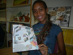
Presentations: developing a lifetime skill
Over the next 3 classes students will work on the skill of making a brief introductory presentations on their classmates. To be emphasized:
1. spelling of the person's name.
2. clarity in speech.
3. appropriate posture.
4. proper language.
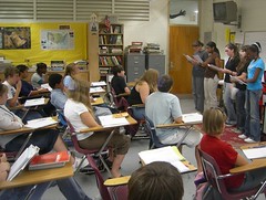
1. spelling of the person's name.
2. clarity in speech.
3. appropriate posture.
4. proper language.
Going to find additional books for school and Just in Time supply
Just In Time (JIT) is an inventory strategy implemented to improve the return on investment of a business by reducing in-process inventory and its associated costs, says Wikipedia.org.
The process is driven by a series of signals, or Kanban, that tell production processes when to make the next part. Kanban are usually 'tickets' but can be simple visual signals, such as the presence or absence of a part on a shelf. When implemented correctly, JIT can lead to dramatic improvements in a manufacturing organization's return on investment, quality, and efficiency.
New stock is ordered when stock drops to the re-order level. This saves warehouse space and costs. However, one drawback of the JIT system is that the re-order level is determined by historical demand. If demand rises above the historical average demand, the firm will deplete inventory faster than usual and cause customer service issues.
Thus store clerks do not "Go to the back" to replenish stock today. Closets and warehouses are kept empty by businesses trying to be competitive. When an item is depleted retailers will fill customers needs by saying "We will order it. Should arrive in 5 to 7 days."
In other words, beware the assumption that a store will carry plenty of copies of the Rand McNally Quick Reference World Atlas. Call before you go, please.
Demographics: study of trends in the population
On the first day in geography class the term was 'demographics." We looked at a profile of Trudeau's classes' middle school background. A little over 50% of students said they were from Caddo Middle. After that school, the distribution was widespread. A dozen schools are represented. Sadly, only one student in some 140 said they'd gone to a school outside of North La.
Detecting patterns, or trends, in the statistics is the more difficult task. One interpretation of the effect of a wide number of schools represented in the first-year group is to assume most students are looking for new friends.
The lack of regional diversity - almost no out of state students - is evidence of stagnation, said Trudeau. Indeed, the Times recently reminded the public that Shreveport's population is shrinking.
Demographics refers to selected population characteristics, says Wikipedia.org, as used in government, marketing or opinion research, or the demographic profiles used in such research.
Commonly-used demographics include race, age, income, disabilities, mobility (in terms of travel time to work or number of vehicles available), educational attainment, home ownership, employment status, and even location.
Demographic trends describe the changes in demographics in a population over time. For example, the average age of a population may increase.
Asking students whether they had a Myspace page or Facebook page (or both) produced one type of profile of student internet usage. Some 80% of students responded that they are active on one of the popular sites. Perhaps 15% said they were active on both sites.
A profile of the current generation as cited by Wikipedia says:
Generation Y cohort, also called N Generation (born from 1984 to 2001)
* Memorable events: rise of the internet, September 11 attacks, cultural diversity, 2 wars in Iraq.
* Key characteristics: quest for physical security and safety, patriotism, heightened fears, acceptance of change, technically savvy, environmental issues.
From the Greek de·mos (dē'mŏs') n.
1. The common people; the populace.
2. The common people of an ancient Greek state.
graphy: writing
Monday, August 13, 2007
Welcome to Magnet!
Most of my students are first-years and are ambitious about college and careers. Today, 14 year-old students are aware that the first day at high school is like reporting to work. You don't get an immediate salary; the payoff comes in the summers when you apply for jobs, camps and internships. The biggest payoff comes at the end of 4 years. Graduation will bring serious scholarship money to many of you.
One of your keys to success in testing and general academics will be methods developed in your social studies class. We will work on the communications skills needed in the fast-paced and challenging world you will hit in about 2015.
One of my tasks is to make the learning as much fun as it can be.
The skills? Among them are -
- accuracy and comprehension in reading.
- fluency in essay writing.
- organized approach to notes and projects.
- test-taking skills.
- digital presentations.
- ethics and manners.
We will build a community of scholars. It's cool to be intelligent and responsive at Cmhs. You're going to like that factor. It's cool not to stick with a clique at Magnet. Our students have a history of being friends with a wide cross-section of classmates. You're about to find a large pool of students who are looking for new friends. What could be finer?
Friday, August 10, 2007
Time Magazine's overview on New Orleans, katrina and the future: "The Threatening Storm" by Michael Grunewald
This is a 3900 word article from Time magazine re New Orleans, Katrina and the future. It is appropriate for geography class in many ways. While it may take a while to work through it, it will be the first unit in our class. There will be quizzes and hands-on projects to accompany the reading. There will be a classroom set of articles for in-class work.
Thursday, Aug. 02, 2007
The Threatening Storm
By Michael Grunwald
The most important thing to remember about the drowning of New Orleans is that it wasn't a natural disaster. It was a man-made disaster, created by lousy engineering, misplaced priorities and pork-barrel politics. Katrina was not the Category 5 killer the Big Easy had always feared; it was a Category 3 storm that missed New Orleans, where it was at worst a weak 2. The city's defenses should have withstood its surges, and if they had we never would have seen the squalor in the Superdome, the desperation on the rooftops, the shocking tableau of the Mardi Gras city underwater for weeks. We never would have heard the comment "Heckuva job, Brownie." The Federal Emergency Management Agency (FEMA) was the scapegoat, but the real culprit was the U.S. Army Corps of Engineers, which bungled the levees that formed the city's man-made defenses and ravaged the wetlands that once formed its natural defenses. Americans were outraged by the government's response, but they still haven't come to grips with the government's responsibility for the catastrophe.
They should. Two years after Katrina, the effort to protect coastal Louisiana from storms and restore its vanishing wetlands has become one of the biggest government extravaganzas since the moon mission--and the Army Corps is running the show, with more money and power than ever. Many of the same coastal scientists and engineers who sounded alarms about the vulnerability of New Orleans long before Katrina are warning that the Army Corps is poised to repeat its mistakes--and extend them along the entire Louisiana coast. If you liked Katrina, they say, you'll love what's coming next.
Before Katrina, the Corps was spending more in Louisiana than in any other state, but much of it was going to wasteful and destructive pork instead of protection for New Orleans; one Corps project actually intensified Katrina's surge. After Katrina, a series of investigations ripped the Corps for building flimsy floodwalls in soggy soils, based on wildly flawed analyses--and shoddy engineering was only one way the Corps betrayed New Orleans. But while FEMA director Michael Brown's resignation made front-page news, Corps commander Carl Strock's resignation hardly made the papers. By the time Strock admitted his agency's "catastrophic failure" eight months after the storm, the U.S. had moved on.
As the disaster's Aug. 29 anniversary approaches, there will be plenty of talk about the future of New Orleans---how to rebuild; bring home the diaspora; and deal with crises like housing, crime and education. But in the long run, recovery plans won't matter much if investors, insurers and homesick evacuees can't trust the Corps to prevent the city from drowning again. "Katrina wasn't even close to the Big One," says Louisiana State University (LSU) hurricane researcher Ivor van Heerden, author of the Katrina memoir The Storm. "We better start getting ready."
Today, Corps leaders are rebuilding New Orleans levees, but they say it will still take four more years and billions of dollars more just to protect the city from a 100-year storm, the protection they were required to provide before Katrina. That's still paltry compared with Amsterdam's 10,000-year-storm protection. But Corps officials have also committed to restoring the surge-softening marshes, cypress swamps and barrier islands that are disappearing at a rate of a football field nearly every half-hour. They say they now understand that the survival of New Orleans depends on a sustainable coast. "This is not the Corps of old," says Karen Durham-Aguilera, director of the agency's Task Force Hope. "The world has changed, and the Corps is changing too."
But for all the talk about restoring wetlands, almost every dime of the $7 billion the Corps has received since Katrina is going to traditional engineering: huge structures designed to control rather than preserve nature. And its latest plan seeks to extend those structures along the entire coast, calling for such massive levees across so much of the state that scientists call it the Great Wall of Louisiana. The Corps says it's just an idea, but Congress is about to authorize the first stretch of the wall--a $900 million, 72-mile (116 km) levee for isolated bayou towns like Chauvin, Dulac and Montegut. "Nothing has changed," says G. Edward Dickey, a former Corps chief of planning. "It's the same engineering mentality, except now they'll build the levees even bigger."
Bigger levees aren't all bad. New Orleans desperately needs them; one local slogan is, "Make Levees, Not War." But New Orleans needs its eroding wetlands just as desperately; another local slogan is, "Fix the Coast, or We Are Toast!" To prevent another disaster, the construction addicts of the Corps, their enablers in Congress and the U.S.'s cockamamie approach to water resources will all have to change. The Great Wall concept sounds a lot like the mistakes of the past.
KILLING THE COAST
NEW ORLEANS WASN'T ALWAYS A CITY IN A bowl. The French founded it in 1718 on high ground along the Mississippi, a "natural levee" of sediment deposited by the river. That's why tourists in the French Quarter stayed dry during Katrina. And that's how all of south Louisiana was built--by the Mississippi River mutinying its banks and rambling around its floodplain like an unruly teenager, dropping mud around its delta and creating roughly 4.5 million acres (1.8 million hectares) of wetlands between New Orleans and the Gulf. So while the French built an earthen levee 1 mile long and 3 ft. high (1.6 km long, 1 m high) to block the river's annual tantrums, they didn't bother trying to block the occasional hurricanes that swept up the Gulf. "They didn't need hurricane levees," says Kerry St. Pe, a marine biologist whose ancestors arrived in 1760. "They had wetlands to protect them." New Orleans wasn't on the coast, and hurricanes wilt over land.
Now the Gulf has advanced some 20 miles (32 km) inland, thanks in large part to the Army Corps. The Corps started as a Revolutionary War regiment, fortifying Bunker Hill, but it evolved into an all-purpose engineering unit, eventually overseeing local flood control on the Mississippi. The Corps ordered communities to imprison the river in a narrow channel with a strict "levees only" policy, rejecting calls to give the river room to spread out. So levees rose, and the Corps repeatedly declared the river floodproof. But the constrained river also rose, and its jailbreaks repeatedly proved the Corps wrong. In the epic flood of 1927, crevasses shredded the entire valley and nearly destroyed New Orleans.
Congress rewarded this failure by allowing the Corps to seize control of the entire river and its tributaries, an unprecedented Big Government project that foreshadowed the New Deal and established the Corps as the U.S.'s manipulator of water and manhandler of nature. It built dams, floodways, revetments and pumped-up levees throughout the Mississippi basin, caging the beast in its channel, safeguarding riverfront cities, creating a reliable web of liquid highways. But by walling off the river, trapping its sediments behind giant dams and armoring its erosive banks with concrete, the Corps inadvertently choked off the land-building process. The straitjacketed river now carries less than half its original sediment load down to Louisiana. So there's little new land-building material to offset the natural erosion of the coast, much less the unnatural rising of the sea fueled by global warming.
The result is that New Orleans is sinking, and about 30% of the coast's wetlands have slipped into the Gulf, jutting Louisiana's chin even further into the path of Mother Nature's fist, endangering the U.S.'s largest offshore oil and gas fields, a lucrative seafood industry, a busy network of ports and about 2 million people. If Mexico had seized all that land, we'd be at war. LSU hydraulic engineer Hassan Mashriqui says just 100 yds. (91 m) of cypress trees can reduce wave energy 95%; he has seen a similar phenomenon with mangroves in his native Bangladesh. Katrina and then Hurricane Rita confirmed that marshes knock down surges as well. "Basically, we found that none of the levees that failed were protected by wetlands or trees," Mashriqui says.
Oil and gas canals have accelerated the land losses. But so have Corps navigation canals, especially the notorious Mississippi River Gulf Outlet, a shipping shortcut to the Port of New Orleans that was a larger dirt-moving project than the Panama Canal when it opened in 1965. The canal never carried many ships, but it has carried plenty of saltwater into freshwater marshes and cypress forests, killing nearly 100 sq. mi. (259 sq km) of wetlands. Shortly before Katrina, Mashriqui called it a "critical and fundamental flaw" in New Orleans' defenses; after Katrina, his modeling found that the outlet boosted Katrina's surge 2 ft. (0.6 m) and increased its velocity 10-fold, overwhelming St. Bernard Parish and the Lower Ninth Ward. "This was a disaster created by the Corps," Mashriqui says.
A TRAGEDY OF PRIORITIES
NEW ORLEANS STILL MIGHT HAVE FENDED off Katrina if its levees hadn't played matador defense. After Hurricane Betsy pummeled New Orleans in 1965, Congress assigned the Corps to protect the city from a 100-year storm. The agency's first mistake was calculating that 100-year event as a modest Category 3 hurricane, even though Betsy had been a 4, and the National Weather Service later proposed a more severe 4. The Corps then made such egregious engineering errors that it wasn't even ready for a smaller storm. For example, its levees sagged as much as 5 ft. (1.5 m) lower than their design because the Corps miscalculated sea level and then failed to adjust for subsidence. Some were built in soils with the stability of oatmeal. "These were inexcusable, lethal mistakes," says University of California, Berkeley, engineering professor Robert Bea, who led a post-Katrina investigation for the National Science Foundation. The Corps also built most of its levees around swampland, a conscious effort to promote the development of low-lying subdivisions like New Orleans East. That no longer seemed like such a good idea after New Orleans East went underwater during Katrina. "That should be the first lesson: build levees around people, not around wetlands," says Paul Harrison of Environmental Defense.
The basic problem is that protecting New Orleans from deadly storms was never anyone's top priority. That's why the city's main hurricane project was 37 years behind schedule when Katrina hit. Louisiana's congressional delegation steered Corps funds toward boondoggles that had nothing to do with flood protection, like a $2 billion effort to channelize the Red River for barges that never materialized. Stingy local officials actually helped scuttle a Corps plan to build pumps and floodgates along Lake Pontchartrain, a plan that could have prevented much of Katrina's flooding. "We can beat ourselves up about the past--or we can use the past to do business differently in the future," says Corps Colonel Jeffrey Bedey, who is now overseeing construction of, yes, huge pumps and floodgates along Lake Pontchartrain. "I don't just mean we the Corps. I mean we the country."
Corps leaders often say their projects simply reflect the will of the nation; when the U.S. wanted them to ransack the landscape with dams and dredges, they saluted and obeyed. But it's also true that the Corps helps shape that will. In recent years the Government Accountability Office, the National Academies of Science and the Pentagon inspector general have documented the agency's bias toward approving projects that keep its 35,000 employees busy and its congressional paymasters happy. In 2000 its leaders were caught cooking an economic analysis to justify a $1 billion upper Mississippi River lock project and launching a secret Program Growth Initiative to lard their budget with make-work. In New Orleans, the Corps endorsed a $750 million lock on the Industrial Canal even though its economists considered it a waste of money; the agency justified it by citing increasing use, even though use was decreasing.
Pam Dashiell, a community activist in the Lower Ninth Ward, fought for years against the Gulf Outlet and the Industrial Canal lock, lobbying Corps officials and Louisiana politicians to focus on safety instead. But both projects were on the wish list of the port, the city's most powerful interest. Dashiell remembers the hostility of Congressmen like Democrat William Jefferson, now indicted on corruption charges, and Republican David Vitter, now embroiled in a prostitution scandal. "They said I was an obstructionist," she says. "I was like, 'Where are your priorities?'" Her working-class Holy Cross neighborhood had one of the highest elevations in New Orleans, but it was nearly wiped out by the surge that blasted up the Gulf Outlet and tore through floodwalls along the Industrial Canal--just a stone's throw from the white-elephant lock project.
For the U.S.'s water-resources system, these haphazard priorities are a feature, not a bug. The Corps is funded almost exclusively by earmarks, individual slices of pork requested by individual Congressmen. Since F.D.R., Presidents have routinely tried to rein in the agency, with little success. After the Program Growth scandal, the Clinton Administration issued a gentle reminder that Corps generals are supposed to report to their superiors in the Pentagon chain of command but speedily retracted it following a venomous outcry from their real superiors on Capitol Hill. President Bush keeps proposing zero funding for most of the Corps projects that taxpayer and environmental groups hate, but Congress continues to fund them anyway.
So the U.S. has no water-resources policy, just a ready-to-build water-resources agency whose agenda is dictated by an annual funding free-for-all among its 535 bosses. It's a classic example of Washington's iron triangle: commercial interests lobby the Corps and their Congressmen for projects that supply the Corps with work and political cover and help the Congressmen steer jobs and money to constituents and contributors. "It's a sinister system," says American Water Resources Association president Gerry Galloway, a former Army brigadier general who is now a visiting scholar at the Corps. "Water is a national-security issue, but we treat it like the Wild West. The big guns get the money."
Katrina didn't change that system. Louisiana Senators Vitter and Mary Landrieu promptly proposed a bloated quarter-trillion-dollar Louisiana reconstruction bill, drafted by lobbyists for oil, shipping and other corporate interests. The request included $40 billion for the Corps--10 times the agency's budget for the rest of the nation--including nonreconstruction projects like the Industrial Canal lock and a New Iberia port deepening that had flunked the Corps' cost-benefit tests.
It also included pre-Katrina coastal levee schemes, with names like Morganza-to-the-Gulf and Donaldsonville-to-the-Gulf to suggest their grandiose sweep. The bill stalled after it was widely mocked as legislative looting, but it sent the message that pre-Katrina priorities were still in effect. Vitter kept pushing a measure to help timber companies harvest cypress swamps. Landrieu tucked language into emergency bills ordering the Corps to redo its New Iberia analysis and fast-tracking the Industrial Canal lock. "Katrina was just a perfect excuse to pull the old pork off the shelf in the name of otherwise-we-drown," says Tulane law professor Oliver Houck, the sage of Louisiana environmentalism. "And away we go: another Louisiana hayride."
THE PATH FORWARD
THE HAYRIDE HAS NOT YET LEFT THE BARN. Since Katrina, the Corps has focused on repairing and improving its New Orleans defenses: rebuilding or strengthening 220 miles of the city's 350 miles of levees (about 350 km of New Orleans' 560-km levee system), installing gigantic pumps and gates along the lake and releasing block-by-block maps to publicize lingering flood risks. Some engineers believe the new levees are still too short and weak--"They're a frigging disgrace," U.C. Berkeley's Bea says--and the new pumps repeatedly malfunctioned during testing. But the Corps is about to unveil its plan for 100-year protection, with a rumored price tag of $15 billion, and the agency says that by 2011 the city will be safe from "severe storms," though not from storms as severe as Katrina. The Corps has even proposed to close the Gulf Outlet, a stunning turnaround after 40 years. "We're being much, much more conservative," says Thomas Podany, a Corps manager in New Orleans.
The real controversies involve a separate study of Category 5 protection and restoration for the entire Louisiana coast. The initial plans floated by the Corps and its state partners proposed a Maginot Line of towering new levees that evoke the "levees only" policy that failed on the Mississippi River, this time seeking to confine the Gulf. Water needs to go somewhere, and the agency's own modeling suggested that Donaldsonville-to-the-Gulf would not only cut off vast swaths of wetlands but also double storm surges in some areas by piling up water and concentrating its fury. "They're talking about chopping an estuary in half," says John Lopez, a former Corps geologist who is now the Lake Pontchartrain Basin Foundation's director of coastal sustainability. "Even for the Corps, that's extreme."
Morganza-to-the-Gulf is less extreme but imminent; it's part of a $20 billion national package of Corps projects nearing congressional approval. The Corps has proposed to use "leaky levees" to allow tidal exchange, but many scientists predict the structures will still wall off marshes, providing a false sense of security to vulnerable towns while increasing their vulnerability. LSU's Van Heerden calls it "absolutely screwy, the exact opposite of what we need." Many scientists argue that it's dangerous and unrealistic to commit billions of dollars to protect middle-of-nowhere fishing towns, when the Corps has a $58 billion backlog of unfinished projects, and cities like New York and Miami are largely exposed to the sea. They want the Corps to focus on fixing the coast and protecting denser communities while helping families in small coastal towns elevate homes or move to higher ground. "I'm afraid that once we say yes, we're giving clearance to levees all across the state," says LSU ecologist Robert Twilley, who's leading Louisiana's science-review team. "My great fear is that we're going to cut off the coast with barriers, just like we did to the river. I'd hate for that to be my legacy."
Even Morganza's most ardent defenders say coastal levees can have dire coastal consequences. But they don't want to do nothing for people in harm's way. "I sit up at night and ask myself, Why the hell do you want to spend $1 billion on another levee?" says Jerome Zeringue, a biologist who runs the local levee district. "But if we don't protect Dulac, there won't be a Dulac."
In Shrimpers Row in tiny Dulac, a sign says WATER ON ROAD AHEAD--not a flashing sign, a permanent sign. Ivy Pierre has fished these bayous since he was a kid. He says the biggest change over his 78 years is that he walks up a ladder instead of down a ladder to climb into his boat. "We're sinking!" he says. Katrina was the fifth time his house has flooded, but home is a powerful place. "They call it Dulac," he says with a grin, "because we Du what we Lac!"
Dulac is ground zero in an age-old coastal debate: Defend or retreat? It's worth noting that the people of Dulac didn't move into harm's way. Harm moved into their way when the coast collapsed around them. But levees can create perverse incentives; Pierre wanted to elevate his house until he heard the Feds might protect it for him. Pierre also understands that Dulac might be doomed, or at least a bit remote for American taxpayers to protect for more than $10 million a mile, and he might be willing to move to higher ground for the right offer. "Retreat is not an American thing," Houck says. "We need a better word for it, because the concept is inexorable."
Corps managers say they're open to non-structural approaches to reducing flood risk. They also say they might adjust their levee paths to avoid damaging the coast. But expectations are hardening. "Morganza is considered egregious in the scientific community, but there's not a lot of enthusiasm down there for changing the alignment," says Randy Hanchey, who left the Corps after 37 years to oversee coastal projects for Louisiana. "The politics are very tricky."
Levees are still seen as instant local relief, even though Morganza is supposed to be a 16-year project and would probably take much longer. Restoration is often cast as a more general solution, even though scientists expect the Gulf to advance to the New Orleans suburbs within a decade. So political pressure and engineering instincts tend to favor a futile effort to wall ourselves off from nature. But Katrina and Rita wiped out 217 sq. mi. (562 sq km) of wetlands in a single month. And even Bush has acknowledged that without the coast, Louisiana is toast.
The good news is that scientists believe they know how to save it. They want the Corps to let go of the river in strategic areas so it can get back to work building land, even if that requires rearranging navigation at the mouth of the Mississippi. They want to fill in oil and gas canals, constrict the Gulf Outlet and start pumping sediment back into ridges and barrier islands. The Corps developed $14 billion worth of Louisiana restoration plans before Katrina, but Bush scaled them back to $2 billion. Now the scientists want to think even bigger about the entire ecosystem, even the sediments trapped behind dams 1,000 miles upstream (about 1,600 km). And they don't want to have to think about new to-the-Gulfs schemes that could further degrade the coast.
Can the system adapt? The Corps has announced "12 actions for change," but it's hard to find outsiders who believe that it has moved beyond its "teach Mother Nature a lesson" roots. It's still not a Corps of ecologists. And its projects are still a popular form of political swag for its enablers on Capitol Hill. The $20 billion Corps package also includes some modest reforms that would require more review of the agency's projects and mitigation of their environmental damage. But the Senate overwhelmingly rejected an effort to require the prioritization of Corps projects according to national need. And on Wednesday, the Bush Administration threatened to veto the "unaffordable" bill. Lieut. General Robert Van Antwerp, the new Corps commander, would like to see an independent commission recommending water projects outside the political process, like the one that advises military-base closures. But if New Orleans has to wait for an independent commission, it's probably time to invest in scuba gear. "We've got to break the cycle," Twilley says. "We've got to stop the political hacking. If we really want to go to the moon, we ought to go."
The scientists make the task sound simple: build New Orleans 500-year protection and restore its natural protection. Have the courage to cause inconvenience and economic harm to some in the name of protecting all. After all, Katrina was harmful too. Moving 30 million tons of debris was pretty inconvenient. And the next Katrina is a question of when, not if.
Since Katrina, New Orleans has lost more than one-third of its population, and only two of St. Bernard Parish's 26 child-care centers have reopened. In the Lower Ninth Ward, floodwalls have been rebuilt and reinforced, but behind them stand blocks full of overgrown lots, where the remains of a gas meter or front step here or there provide the only evidence of the houses and lives washed away. "I look at this, and I think of the shortsighted people who crippled a great city," Dashiell says. She knows that city needs better hospitals and more jobs. But first, better levees and more wetlands. Otherwise, it's going to need an obituary.
Subscribe to:
Posts (Atom)
