Caddo Quiz / geography / Trudeau
1. The name for the state of __ used by one of the tribes of the Caddo nation has come into widespread use. a) Louisiana b) Mississippi c) Texas d) Oklahoma
2. The home of the Caddo today: a) Louisiana b) Mississippi c) Texas d) Oklahoma
3. The first European explorer to visit the Caddo: a) Iberville b) DeSoto
c) Bienville d) Nacogdoches.
4. Principal nations involved in colonization: a) France & Spain b) France & England c) Spain & England.
5. The Caddo were devastated by diseases brought by the colonials. Another word for devastated: a) damned b) defiled c) dislocated
d) decimated.
6. Which group first invaded the Caddo lands? a) Osage b) US troops c) European colonists d) Choctaw.
7. Based on the sound and appearance of the word, the term Anglo must refer to the settlers from a) England b) Spain c) France d) Germany.
8. Was the date of the Louisiana Purchase before or after the US treaty with the Caddo? a) before b) after c) both.
9. One of Louisiana's neighbors was classified as a separate and foreign nation during the 1800s. That was a) Alabama b) Texas c) Arkansas d) Mississippi.
Please see the reading on which these questions are based:
http://mondotrudeau.blogspot.com/2010/08/what-background-of-name-of-this-august_17.html
1. Texas 2. Oklahoma 3. DeSoto 4. France & Spain 5. decimated
6. Osage 7. England (see the ngl sound) 8. before 9. Texas
Tuesday, August 31, 2010
Sunday, August 29, 2010
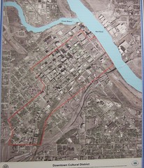
Project on the Five Themes of Geography as they apply to Shreveport
Students will add color to a one-sheet project based on a map of Shreveport-Bossier that includes notes illustrating The 5 Themes of Geography and the municipality of Shreveport. In group work students will also compose 9 multiple-choice questions based on the 5 Themes material. Include answers. Up to 5 pts to be awarded in class.
* Location
- Relative Location - Shreveport is 3 hours east of Dallas. It is 4 hours drive north of Houston. It is also over 6 hours drive north of New Orleans.
- Absolute Location - Shreveport: 32N, 94W
* Place
- Human Characteristics - Shreveport's population is about 51% African-American and 47% Caucasian.
- Physical Characteristics - Shreveport is part of the Gulf Coastal Plain and the valley of the Red River.
* Human-Environmental Interactions
- Humans adapt to the environment - much of the year is hot and humid. Might that be why the city has relatively few sidewalk cafe tables?
- Humans modify the environment - the edge of the Red River is marked by casinos, Riverview Park and the Fant Parkway bike trail.
- Humans depend on the environment - Shreveport's water supply is Cross Lake. Bossier's water supply is the Red River.
* Movement
- People - Shreveport's indigenous population was forced out of the region in the mid 1800's. The Caddo mostly re-settled in Oklahoma.
- Goods - Until recently the GM Hummer was manufactured in Shreveport.
- Ideas - Tax incentives offered by the state have drawn Hollywood movie productions to Shreveport.
* Regions
- Formal - The state of Louisiana.
- Functional - NW La.
- Vernacular (perceptual) - the Bible Belt.
More examples of the 5 Themes here.
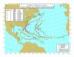
In-class project: Atlantic storm tracking map
Student maps should be spread across 2 notebook pages (N & S Amer on the left, Europe & Af on the right). Include the outlines of the following land masses:
Western Europe
West Africa
S America
Central America
N Amer
Cuba (separates the Caribbean from the Gulf)
Atlantic
Caribbean
Gulf of Mexico
Ocean currents:
- N and S Equatorial
- N Atlantic
- Gulf Stream
- Canary
Equator
Prime Meridian
Tropics
40N, 40S and 50W, 2E
Use color.
Add a title.
Western Europe
West Africa
S America
Central America
N Amer
Cuba (separates the Caribbean from the Gulf)
Atlantic
Caribbean
Gulf of Mexico
Ocean currents:
- N and S Equatorial
- N Atlantic
- Gulf Stream
- Canary
Equator
Prime Meridian
Tropics
40N, 40S and 50W, 2E
Use color.
Add a title.
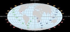
Basics of geography: the projections used in constructing maps
Goal: that students demonstrate knowledge that there are many ways to scientifically create maps.
See this article and illustrations at the US Geological Survey site.
A map projection is used to portray all or part of the round Earth on a flat surface. This cannot be done without some distortion.
Every projection has its own set of advantages and disadvantages. There is no "best" projection.
The mapmaker must select the one best suited to the needs, reducing distortion of the most important features.
Mapmakers and mathematicians have devised almost limitless ways to project the image of the globe onto paper. Scientists at the U. S. Geological Survey have designed projections for their specific needs—such as the Space Oblique Mercator, which allows mapping from satellites with little or no distortion.
This document gives the key properties, characteristics, and preferred uses of many historically important projections and of those frequently used by mapmakers today.
Which ones best suit your needs?
Every flat map misrepresents the surface of the Earth in some way. No map can rival a globe in truly representing the surface of the entire Earth. However, a map or parts of a map can show one or more—but never all—of the following: True directions. True distances. True areas. True shapes.
For example, the basic Mercator projection is unique; it yields the only map on which a straight line drawn anywhere within its bounds shows a particular type of direction, but distances and areas are grossly distorted near the map's polar regions.
On an equidistant map, distances are true only along particular lines such as those radiating from a single point selected as the center of the projection. Shapes are more or less distorted on every equal-area map. Sizes of areas are distorted on conformal maps even though shapes of small areas are shown correctly. The degree and kinds of distortion vary with the projection used in making a map of a particular area. Some projections are suited for mapping large areas that are mainly north-south in extent, others for large areas that are mainly east-west in extent, and still others for large areas that are oblique to the Equator.
The scale of a map on any projection is always important and often crucial to the map's usefulness for a given purpose. For example, the almost grotesque distortion that is obvious at high latitudes on a small-scale Mercator map of the world disappears almost completely on a properly oriented large-scale Transverse Mercator map of a small area in the same high latitudes. A large-scale (1:24,000) 7.5-minute USGS Topographic Map based on the Transverse Mercator projection is nearly correct in every respect.
A basic knowledge of the properties of commonly used projections helps in selecting a map that comes closest to fulfilling a specific need.
Open notes, multiple choice quiz on Th/Fr: identifications, vocab and reading comprehension
The weekly geography quiz will comprise -
- vocab, such as mnemonic, pimento and hydrology.
- identifications such as meridian and parallell.
- reading comprehension from a selection on map projections.
- from 11 to 15 questions.
Your homework every night: read and notate the web site.
- vocab, such as mnemonic, pimento and hydrology.
- identifications such as meridian and parallell.
- reading comprehension from a selection on map projections.
- from 11 to 15 questions.
Your homework every night: read and notate the web site.
Mississippi valley map quiz Tues/Wed: 15 pts on memorization & spelling
Mississippi valley map quiz as announced and practiced in class on Fri:
Students will rapidly create and label a sketch map on a blank sheet of paper.
Mnemonics will make the task an easy preparation.
- Blocky sketch showing states and rivers in their general perspective.
- 10 states - each correctly spelled.
- 4 tributaries - spelling!
- Gulf of Mexico

Students will rapidly create and label a sketch map on a blank sheet of paper.
Mnemonics will make the task an easy preparation.
- Blocky sketch showing states and rivers in their general perspective.
- 10 states - each correctly spelled.
- 4 tributaries - spelling!
- Gulf of Mexico
Friday, August 27, 2010
Holistic teaching: kinesiology, oxygenation and stress relief
If I teach you ways to stimulate your brain and relax your muscles then your overall performance at school may be enhanced. It's part of holistic teaching.
Some guiding ideas -
Teachers can design holistic teaching practices, says the Univ of Wisconsin, by creating lessons which incorporate learning experiences from all three domains: the cognitive (thinking), the affective (feeling), and the psychomotor or physical (kinesthetic, tactile, and/or physical).
Kinesiology, from the Greek words kinesis (movement) and kinein (to move), also known as human kinetics, is the science of human movement. It is a regulated health profession that focuses on physical activity.[1]
Oxygenation occurs when oxygen molecules (O2) enter the tissues of the body. For example, blood is oxygenated in the lungs, where oxygen molecules travel from the air and into the blood.
The body’s natural relaxation response is a powerful antidote to stress. Relaxation techniques such as deep breathing, visualization and progressive muscle relaxation can help you activate this relaxation response.
Fifth anniversary of the flooding of New Orleans and decimation of the Gulf Coast by Hurricane Katrina
In important ways the hurricane spared New Orleans: winds and rain were manageable. But the larger pattern of storm winds pushed massive amounts of water into channels and canals around the Crescent City.
Then the levees failed.
The breaching of the levees by high waters produced the flooding that devastated New Orleans.
Here's the Times-Picayune (Nola.com) interactive description of the disaster.
Along the Mississippi Gulf Coast the winds, rain and tidal surge of Katrina were cataclysmic. In Louisiana, the small city of Slidell was horribly stricken by high winds and storm-forced flooding.
Thus "Katrina" was a true monster.
Spaceship earth: teaching and using the system of coordinates that we call latitude and longitude
Teaching coordinates and Spaceship Earth
1. Color, cut and paste globes of lat. and long. from p. 5, textbook.
- Identify sample coordinates; see the terms parallel and meridian.
- Use the globes as part of your Spaceship Earth Teaching Project.
2. Great Circle route sketches, p 6.
3. What's distorted on a Mercator projection? Is a Robinson projection
more accurate than a Mercator? Why?
4. Making our own Atlantic Hurricane Tracking map
- refer to WG, p. 28 and p. 63. Identify -
Europe
Africa
S America
North Amer
Gulf Stream
North Atlantic Current
Canary Current
Equatorial Current (N Equatorial and S Equatorial)
Read about the Coriolis Effect on prevailing winds.
5 themes of geography . . .
Location of the people? Manhattan
Character of the place? Island at confluence of
Interaction of people and the place?
Movement of people, goods and ideas?
Comparison of places: how are they similar and how different?
Thursday, August 26, 2010
Indigenous peoples: the original inhabitants
The adjective indigenous has the common meaning of "from" or "of the original origin".
Indigenous peoples are people, communities, and nations who claim a historical continuity and cultural affinity with societies endemic to their original territories that developed prior to exposure to the larger connected civilization associated with Western culture, says Wikipedia.
Other terms for indigenous peoples include aborigines, aboriginal people, native people, first people, fourth world cultures and autochthonous.
Wednesday, August 25, 2010
What does a Hydrologist do?
One of the themes of geography class is water and its scarcity and how to share it smartly.
Hydrology is the study of the movement, distribution, and quality of water throughout the Earth, says Wikipedia, including the hydrologic cycle and water resources. A practitioner of hydrology is a hydrologist, working within the fields of either earth or environmental science, physical geography, geology or civil and environmental engineering.
Domains of hydrology include hydrometeorology, surface hydrology, hydrogeology, drainage basin management and water chemistry, where water plays the central role. Oceanography and meteorology are not included because water is only one of many important aspects.
Hydrological research can inform environmental engineering, policy and planning.
The term hydrology is from Greek: ὕδωρ, hydōr, "water"; and λόγος, logos, "study".
Fruit or nuts as a school day snack, rather than crunchy Cheetos (which, in truth, I love)
The theme of holistic teaching means we should try to reach each learner through a variety of means. Thus I care about establishing healthy snacking patterns for students at Magnet.
Bring a fruit or nut snack to class in the next class for a bonus of 2 pts.

Bring a fruit or nut snack to class in the next class for a bonus of 2 pts.
Mimal & Wiktm and mnemonics
Mr Mimal and Mr Wiktm ("Well, I know the math," said one of my students) are not real fellows. They are imaginary people. We call them mnemonics.
Mnemonics are memory aids. They help students learn, especially when it comes to memorization. Mimal helps people remember the states that border the Miss R on the west side. Wiktm is his podna on the east.
In class students used a US map handout to denote the 10 Miss valley states.
Pupils colored them in the practice of tactile learning - using the sense of touch.
Then the class added 5 of the tributaries ("contribute") of the Miss.
- the Ohio, Tenn, Missouri, Ark and Red rivers.
How is that network of rivers like an early form of the internet? That's a question for brief response on the next quiz.
How is a Philadelphia cab driver connected to a dock worker in New Orleans?
There's an answer that relates to our map.
Finally, I call our sketch-based learning the Einstein approach. That's because Einstein used visualization throughout his entire life, says slideshare.net.
At the age of 16 Einstein used visualization when he discovered that the speed of light was always constant. Einstein believed that visual understanding was the most important form of education and more important than knowledge. Later in life Einstein would write: “ I am enough of an artist to draw freely upon my imagination. Imagination is more important than knowledge. Knowledge is limited. Imagination circles the world.”
Spaceship Earth teaching project
Teaching a lesson in latitude and longitude / the Spaceship Earth teaching project
6 pts
Due Th, Fri, Sept 2, 3.
- Using your Spaceship Earth sheet, teach a person review of latitude and longitude.
- Your pupil might be a sibling, a parent, a peer, a child or an adult.
- Identify the equator and prime meridian.
- Sailors, pilots and the makers of GPS (Global Positioning System) devices are among those who depend on this grid system.
- After explaining the coordinate system, have the student add a line of both latitude and longitude to your map.
- Show your student the coordinates for Shreveport on the map: 32N, 94W.
- Ask your student to place these major cities using only the coordinates.
New York City: 40N, 74W
Paris: 49N, 2E
Rio de Janeiro, Brazil: 23S, 43W
Johannesburg, South Africa: 26S, 28E
Complete the project by getting your
Pupil's
- signature,
- status (3rd graders, mom, uncle, etc) and
- occupation (student, etc),
Be prepared to stand and make a brief presentation to the class when the assignment is due.
Tuesday, August 24, 2010
Notes on population, Ramadan and coordinates
Implications of the world population of 6.8 billion -
- a crowded planet, therefore . . .
- food shortages
- water "
- housing "
- jobs "
India: democratic government. Fastest population growth.
China: totalitarian / Communist government. The central authorities control population by the policy that states "One family, one child."
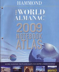
* Required for geography class: Hammond Notebook Atlas or the Rand McNally Notebook Atlas.
Spaceship Earth project -
- Cutting, coloring, pasting, adding info: a tactile, or hands-on lesson.
- World Geo reading on coordinates: pp. 5 - 7, 35, 237.
- Pangaea - theory of massive continent that split apart into today's several continents.
- oblate - oval
Ramadan Mubarak! ("Happy Ramadan!")
- a month of fasting from sunrise to sunset.
- one billion Muslims across the world.
- feast that ends Ramadan: Eid al Fitr.
- a crowded planet, therefore . . .
- food shortages
- water "
- housing "
- jobs "
India: democratic government. Fastest population growth.
China: totalitarian / Communist government. The central authorities control population by the policy that states "One family, one child."
* Required for geography class: Hammond Notebook Atlas or the Rand McNally Notebook Atlas.
Spaceship Earth project -
- Cutting, coloring, pasting, adding info: a tactile, or hands-on lesson.
- World Geo reading on coordinates: pp. 5 - 7, 35, 237.
- Pangaea - theory of massive continent that split apart into today's several continents.
- oblate - oval
Ramadan Mubarak! ("Happy Ramadan!")
- a month of fasting from sunrise to sunset.
- one billion Muslims across the world.
- feast that ends Ramadan: Eid al Fitr.
The implications of 6.8 billion people
Feeding, supplying water, offering housing and creating jobs for a crowded planet is a problem in most nations today.
The recent rapid increase in human population, says Wikipedia, over the past two centuries has raised concerns that humans are beginning to overpopulate the Earth, and that the planet may not be able to sustain present or larger numbers of inhabitants.
The population has been growing continuously since the end of the Black Death, around the year 1400;[2] at the beginning of the 19th century, it had reached roughly 1,000,000,000 (1 billion). Increases in life expectancy and resource availability during the industrial and green revolutions led to rapid population growth on a worldwide level. By 1960, the world population had reached 3 billion; it doubled to 6 billion over the next four decades.
The scientific consensus is that the current population expansion and accompanying increase in usage of resources is linked to threats to the ecosystem. Many environmental problems, such as rising levels of atmospheric carbon dioxide, global warming, and pollution, were believed to be aggravated by the population expansion.[6]
Sunday, August 22, 2010
Enrichment reading: the history of navigation
Enrichment reading: the history of navigation
The first record of boats large enough to carry goods for trade is around 3500 B.C., says boatsafe.com, and this would mark the birth of the art of navigation.These first navigators stayed close to shore and navigated by sight of landmarks or land characteristics that they could see. Usually they traveled by day and sought a calm harbor or anchorage at night. They did not have charts but lists of directions, similar to today’s cruising guides.
When they did venture out of sight of land, the navigator was able to determine his latitude (north/south direction) by observing the height of the sun during the day and the North Star at night.
Please see more at boatsafe.com.
Multiple choice, open notes test: first quiz in geo class on Wed-B/Th-A
For the first quiz, prepare your class notes and notes from MondoTrudeau articles.
Typically your teacher's questions address vocab, facts and implications of the material. Refer to the practice quiz on Caddo history.
The quiz will be an open notes test of some 12 questions. Most questions will be multiple choice.
You must always be ready for a "constructed response" question/answer. That means a question to be answered in 2 or 3 sentences that shows your ability to offer appropriate facts in a mini-essay. You must also show strength in grammar, spelling and construction.
5 pts. Due on Wed/Th.
World geography project: latitude & longitude review via Spaceship Earth poster
This week in class -
Students will demonstrate knowledge of latitude and longitude via a colorful one-sheet project called Spaceship Earth.
Designations -
- equator
- prime meridian
- examples of latitude N and S, of medians both E and W.
- a major city in each quardrant.
- major bodies of water.
- world population
- texture via cutting and pasting 2 elements (I did narrow lines for the equator and the prime meridian.)
- color.
- title.
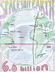
World Geography additional text: The 2009 World Almanac Notebook Atlas by Hammond Atlas Corp
With the help of the local Barnes & Noble staff, I have decided on requiring of my World Geography students the 2009 World Almanac Notebook Atlas (Hammond) by Hammond World Atlas Corporation.
It costs $6.95 at full price.
Barnes & Noble has plenty of store and warehouse stock. You might be able to order it online for the equivalent price or at a savings. Please investigate.
The reasons for requiring an additional atlas:
a) the textbook maps are useful but not as large and detailed as these.
b) the data in the textbook was compiled some 12 years ago.
c) the paperback atlas represents a family resource - it encourages quick use in researching material from TV, movies, books, magazines and discussions.
Please secure the book asap. My extended deadline will be Sept 6.
Questions? trudeau11@gmail.com.
Saturday, August 21, 2010
What's for lunch this week: Pimento Cheese sandwich
Pimento cheese is a common food in the Southern United States. The basic recipe for most pimento cheese spreads has few ingredients: sharp cheddar cheese, mayonnaise, pimentos, salt and pepper, blended to either a smooth or chunky paste[1]. There are a multitude of regional ingredients, which include but are not limited to: Velveeta cheese, Worcestershire sauce, paprika, jalapeños, dill pickles, onions, or garlic[2][3][4].
The primary way pimento cheese is eaten is as a sandwich on soft white bread, and is considered a Southern comfort food[7].
The pimento or cherry pepper is a variety of large, red, heart-shaped chili pepper (Capsicum annuum). The flesh of the pimento is sweet, succulent and more aromatic than that of the red bell pepper.
"Pimiento" is the Spanish word used in English.
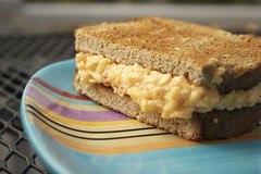
Friday, August 20, 2010
Out of print: the long-valued Rand McNally Quick Reference World Atlas!
You may cease the quest for the Rand McNally Quick Reference World Atlas. I apologize for your inconvenience.
Two weeks before school began I checked online to make sure that copies of my work-horse would be available. There seemed to be a more than adequate supply. Little did I know that Rand McNally had ceased publication of the $6 book. Nor did I realize that the listings of used copies would give way to "out of stock."
Meantime, we will use the maps in the textbook.
Sorry!
Tuesday, August 17, 2010
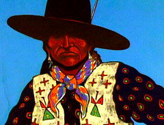
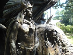
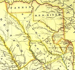
"Caddo:" what's the background of the name of this august secondary school?
"The Caddo Nation is a confederacy of several Southeastern Native American tribes," says Wikipedia, "who traditionally inhabited much of what is now East Texas, northern Louisiana and portions of southern Arkansas and Oklahoma. Today the Caddo Nation of Oklahoma is a cohesive tribe with its capital at Binger, Oklahoma.
The Caddo lived in the Piney Woods eco-region of the United States up to the foothills of the Ozark Mountains and often near the Caddo River.
Several Caddo villages were resettled, including the community of Elysian Fields, Texas, and Nacogdoches and Natchitoches, both of which have kept their original names. The Caddo were progressively moved further west until they reached what is now western Oklahoma.
Caddo food varied in many types, the most common being dried corn. Sunflower seeds and pumpkins were also important staples with cultural significance, as were wild turkeys.
The Caddo first encountered Europeans in 1541 when the Hernando de Soto Expedition came through their lands.[16] De Soto's force had a violent clash with one band of Caddo Indians, the Tula, near Caddo Gap, Arkansas.
The Caddo tribes were divided into three confederacies when first encountered by the Europeans, the Hasinai, Kadohadacho, and Natchitoches, and loosely affiliated with other tribes. The Haisinai lived in East Texas, the Kadohadacho lived near the border of Texas, Oklahoma, and Arkansas, and the Natchitoches lived in now northern Louisiana.[17]
With the arrival of missionaries from Spain and France a smallpox epidemic broke out that decimated the population. Measles, influenza, and malaria also devastated the Caddo, as they were Eurasian diseases to which they had no immunity.[14]
Before extensive European contact, some of the Caddo territory was invaded by migrating Osage, Ponca, Omaha and Kaw, who had moved west beginning about 1200 CE because of years of warfare with the Iroquois in the Ohio River area of present-day Kentucky. The Osage particularly dominated the Caddo and pushed them out of some former territory, becoming dominant in the region of Missouri, Arkansas, Kansas and Oklahoma.
Having given way over years before the power of the former Ohio Valley tribes, Caddos later negotiated for peace with Spanish, French, and finally Anglo-American settlers. After the 1803 Louisiana Purchase, the United States government sought to ally with the Caddos. In 1835 the Kadohadacho, the northernmost Caddo confederacy, signed a treaty with the US to relocate to then Mexico. This area had been rapidly transformed by greatly increased immigration of European Americans, who in 1836 declared independence from Mexico with the Republic of Texas.[14]
"Texas" comes from the Hasinai word táysha, meaning "friend."[18]"
Please answer the reading comprehension quiz which follows on the blog; the questions are taken directly from this article.
Looking historically at the name "Caddo" - a diagnostic quiz
The Caddo in 4 States quiz -
- concepts in social studies
- using context to enrich your vocabulary
1. "Confederacy:" a) organized group b) rebels c) native Americans.
2. "cohesive tribe:" a) conflicted b) sticking together c) diminishing
3. Ozark Mountains: a) southern Arkansas b) northern Arkansas
4. Nacogdoches and Natchitoches were names that came from the: a) settlers
b) native peoples c) we are not sure of the source.
5. This article implies that the Caddo consumed ___ protein. a) much b) little
6. "Kadohadacho" were tribal peoples also known as the a) Hasinai b) Natchitoches c) Caddo.
7. "Decimated" means a) measured b) destroyed c) aided by.
8. The Ohio Valley tribe that overpowered the Caddo: a) Iroquois b) Hasinai c) Osage.
9. In 1836, one year after the founding of Shreve Town, aka Shreveport, the Republic of __ proclaimed freedom from the vast nation of Mexico.
a) Texas b) Oklahoma c) the United States.
10. T / F The name "Texas" comes from the Spanish language term for "friend."
11. "August" has a meaning beyond (see the title of this article) the name of the 8th month: a) high in status b) warm to hot c) small to medium-sized.
1.a2.b3.b4.b5.b6.c7.b8.c9.a10.f11.a
Class of 2014 Talent Show performance night scheduled for Tues, April 19, 6:30 pm, PAC
In the Magnet tradition, the Class of 2014 will enjoy the team-building and celebration of talent that comes from producing an all-freshman talent show.
The performance night will be Tues, April 19, 6:30 pm, in the PAC.
We've accepted a Tues night showtime because the Magnet PAC calendar is chock full of activities. This was the best date available when your sponsor visited the school calendar.
Try-outs will be held Th and Fri, Ap 7 and 8, after school - in the PAC.
The week of Rehearsals will be held during testing week: April 11 - 15.
Performers and production staff (set, costumes, sound & lights, etc) will be expected to be present Mon - Fri from 3:50 to 5 pm (or later, on some days).
Teacher sponsors are Robert Trudeau and Ginger Marks.
We welcome all forms of performance talent: readings, acting, martial arts, dressage, etc. Please see your sponsors for developing the possibilities.
Thursday, August 12, 2010
Water Bottle represents an industry that is far from helpful and deserves a second look by consumers
Tapped, an excellent documentary hitting DVD this week, details, with grim thoroughness, the multiple overlapping evils of the bottled water industry, says NPR.org.
Basically, the film contends, the bottled water industry is an ecological and consumer nightmare from end to end.
Corporations like Coca-Cola, Pepsi and Nestle mine public water sources and sell it back to the public at criminal markup. (Forty percent of bottled water is just recycled tap water from municipal sources.)
Of course, all of this water has to be transported, processed, packaged and retailed – with attendant energy costs. Most of those plastic bottles end up in landfills, or the ocean. The statistics are dispiriting.
According to the film, Americans buy 29 billion single-serve bottles of water each year. About 20 percent are recycled. Transporting the water uses about 18 million gallons of oil.
Saturday, August 07, 2010
US no longer leads in college degrees, ages 25 to 34 - 11 nations ahead of US in finishing degrees
From NY Times columnist Bob Herbert
According to a new report from the College Board, the U.S. is 12th among developed nations in the percentage of 25- to 34-year-olds with college degrees. The report said, “As America’s aging and highly educated work force moves into retirement, the nation will rely on young Americans to increase our standing in the world.”
The problem is that today’s young Americans are not coming close to acquiring the education and training needed to carry out that mission. They’re not even in the ballpark. In that key group, 25- to 34-year-olds with a college degree, the U.S. ranks behind Canada, South Korea, Russia, Japan, New Zealand, Ireland, Norway, Israel, France, Belgium and Australia. That is beyond pathetic.
“While the nation struggles to strengthen the economy,” the report said, “the educational capacity of our country continues to decline.”
Continues Herbert:
But instead of exercising the appropriate mental muscles, we’re allowing ourselves to become a nation of nitwits, obsessed with the comings and goings of Lindsay Lohan and increasingly oblivious to crucially important societal issues that are all but screaming for attention. What should we be doing about the legions of jobless Americans, the deteriorating public schools, the debilitating wars, the scandalous economic inequality, the corporate hold on governmental affairs, the commercialization of the arts, the deficits?
Why is there not serious and widespread public engagement with these issues — and many others that could easily come to mind? That kind of engagement would lead to creative new ideas and would serve to enrich the lives of individual Americans and the nation as a whole. But it would require a heavy social and intellectual lift.
Your teacher:
Bob Herbert is a heavy-handed writer who should avoid words like "nitwits" and the phrase "beyond pathetic." He is "name calling" and demonstrating how writers sometimes take cheap shortcuts in opinion pieces.
Nonetheless, I share his concern. As your teacher I pledge to work hard to ready you for college and other advanced studies.
Subscribe to:
Posts (Atom)
