Students asked about this issue last week in class.
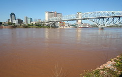
NEW ORLEANS (AP) — Just three years after Hurricane Katrina, New Orleans confronts a new threat from Gustav and a stark question: Will the partially rebuilt levees hold?
levee and drain pipes
Despite $2 billion in improvements, including 220 miles of repaired, raised and replaced floodwalls, 17 new pump stations and more flood-resistant pump stations, nobody can say for sure the city won't be swamped again. And if it is, could it ever recover?
"It's scary, man," said Robert Russell, a 63-year-old plumber whose house in Gentilly Woods is close to floodwalls on the Industrial Canal that are so suspect the Army Corps of Engineers is buffering them with large baskets filled with sand.
"They say it's not up to code," he said. "We'll have to wait and see."
Levee experts and the Army Corps insist New Orleans is safer than before Katrina flooded more than 80 percent of the city on Aug. 29, 2005.
Yet the system still has severe shortcomings: Flood barriers meant only to withstand medium-strength storms, hidden layers of weak soil and navigation channels that inadvertently funnel storm surge into the city, to name a few.
"The positive thing about having any storm hit you, it will reveal any kind of frailty in the system," said J. David Rogers, an engineer at Missouri University of Science and Technology, who's tracked the construction closely. "And we shouldn't be surprised if there is frailty."
Experts estimate the system is only a third of the way to where the corps wants it by 2011 — strong enough to protect against what scientists call a 100-year-storm. That type of hurricane has a 1 percent chance of occurring each year.
By comparison, the corps says Katrina was a 396-year storm, a rare catastrophic hurricane. The agency has not classified Gustav, which was crossing Jamaica Thursday.
"We're not close to 100-year-level protection yet," said Robert Turner, the regional director of the Southeast Louisiana Flood Protection Authority-East. "It's not worth putting your life at risk if you have the means to get out."
Sunday, August 31, 2008
Thursday, August 28, 2008
Hand-sketched map test next Wed: the Mississippi valley
Map quiz:
a) Sketch the 10 states that border the Mississippi River. Label each and spell the states' names correctly.
b) Sketch and label the inlet points of 3 tributaries: the Ohio R, the Missouri R and the Red R.
c) Cite the cities of Minneapolis-St Paul, St Louis, Memphis, Baton Rouge and New Orleans.
18 pts. memorization.
Guidelines for Open Notes tests
Students should be confident that fairness exists across the classroom during tests. To that end I work hard to make sure these guidelines are evenly administered:
1. No communication between students; None whatever. Students may raise their hand and shortly I will arrive at their desk to answer the question. Please whisper your question.
2. You may Not trade or pass notes during the test period.
3. Keep your eyes on your workspace only.
4. You may use all sources of info: textbook, atlas, notes, print outs, reference books in the classroom, even a laptop.
5. Violation of test guidelines? I must call your parents and you must type an essay of correction and contrition.
Tuesday, August 26, 2008
Sample questions to make you ready for the open notes quiz on Thurs, Aug 28
1. The coordinates of this famous American city are approximately 40N, 74W. This must refer to:
a) Denver b) San Diego c) London d) Philadelphia.
2. On a Mercator map which is more distorted? a) Ecuador b) Chile.
3. On a flat Mercator map you see a route that seems to be curved rather than straight across. The curved line does not represent a Great Circle route; it represents a Robinson projection. T / F
4. The source of the Mississippi is Lake a) Titicaca b) Superior
c) Michigan d) Itasca.
Famous cities:
5. 40N, 74W
6. 32N, 35E
7. 32S, 19E
8. 34S, 150E
9. 30N, 90W
10. The region associated with the earliest use of math and mapping: a) Babylonia b) Mesopotamia c) Egypt d) Greece.
11. Greenwich, England, is home to the a) equator b) prime meridian c) oldest section of London.
12. Pythagoras and the grid system are associated with a) Greece b) Egypt c) Mesopotamia.
13. Louisiana is usually thought of as having a place in the __ Hemisphere. a) Eastern b) Western c) Southern d) Cerebral.
14. Use your text to find the coordinate that is described as 0 degrees, 0 minutes and 0 seconds.
It is the a) equator b) prime meridian c) both the equator and prime meridian.
15. Cartographer: a) Vespucci b) diCaprio c) Columbus d) McNally.
16. The Red River flows through or adjacent to the states of Arkansas, Oklahoma, Texas and Mississippi. T / F
answers . . .
1. Philadelphia
2. Chile
3. F
4. Itasca
5. Philadelphia
6. Jerusalem, Israel
7. Cape Town, South Africa
8. Sydney, Australia
9. New Orleans
10. Greece
11. prime meridian
12. Greece
13. Western
14. both
15.Vespucci
16. F
Learning the difference between an ordinary route, called a True Direction route, and a Great Circle route
Tues, Aug 26:
- Sketch, label and color the 2 Great Circle Route maps on p. 6. They are similar but note the differences between them,
- Cut out and color representations of 2 ships and 2 planes appropriate in size to your Great Circle maps.
- Place them upon your map, you ask? Yes! With glue? Perhaps, yes!
A disembodied hand and wrist? One that moves to and fro? If we have the time!
- Knowing the type of route on which you must place the ship and plane
is the key to the lesson.
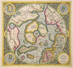
Maps by Gerardus Mercator, mid 1500's
The Mercator projection is a cylindrical map projection presented by the Flemish geographer and cartographer Gerardus Mercator, in 1569, says Wikipedia.
It became the standard map projection for nautical purposes because of its ability to represent lines of constant true bearing or true course, known as rhumb lines, as straight line segments.
While the direction and shapes are accurate on a Mercator projection, it distorts size, in an increasing degree away from the equator.
The nature of the Great Circle route
Great circle routes are used by ships and aircraft where currents and winds are not a significant factor. For aircraft traveling westerly between continents in the northern hemisphere these paths will extend northward near or into the Arctic region, while easterly flights will often fly a more southerly track to take advantage of the jet stream.
A great circle is a circle on the surface of a sphere that has the same circumference as the sphere, dividing the sphere into two equal hemispheres, says Wikipedia.
A great circle is the largest circle that can be drawn on a given sphere. The diameter of a great circle is same as the diameter of the sphere.
When long distance aviation or nautical routes are drawn on a flat map (for instance, the Mercator projection), they often look curved. This is because they lie on great circles. A route that would look like a straight line on the map would actually be longer.
On the Earth, the meridians are on great circles, and the equator is a great circle. Other lines of latitude are not great circles, because they are smaller than the equator; their centers are not at the center of the Earth -- they are small circles instead.
Monday, August 25, 2008
Open Notes Quiz on Thurs, Aug 28
Open notes quiz on Thurs on geographical coordinates (latitude, longitude), plus vocabulary from the Mondotrudeau notes. All questions mult-choice.
Ex question: The coordinate is 40N, 75E. That designates
a) NYC b) Paris, France c) Denver, Colorado d) Philadelphia.
In class:
- Making quizzes on the geographical coordinate system
- Each student will write 10 multiple choice questions on items such as the prime meridian and on the coordinates of famous locations such as Paris, France and Sydney, Australia.
Vocab -
"Ni hau!"
- Mandarin Chinese (northern)
- Mandarin implies noble or learned.
- Most frequently-used “hello” in the world.
The Mississippi Valley project
To be completed mostly in class, this review of the tributaries of the Miss. should have the following items:
1. 10 states - the ones that directly border the Miss.
2. The Miss. river.
3. The major tributaries -
Ohio R.
Tennessee R.
Missouri R.
Arkansas R.
Red R.
4. Add a rim of color to the states. Save a contrasting color for the rivers.
5. Titles (see guidelines).
The Mississippi River[2] is the second longest river in the United States, with a length of 2,340 miles (3,770 km)[3] from its source in Lake Itasca in Minnesota to its mouth in the Gulf of Mexico, says Wikipedia. The longest river, a Mississippi tributary, is the Missouri River measuring 2,540 miles (4,090 km)[4].
The Mississippi River is part of the Jefferson-Missouri-Mississippi river system, which is the largest river system in North America and among the largest in the world: by length (3,900 miles (6,300 km)), it is the fourth longest, and by its average discharge of 572,000 cu ft/s (16,200 m³/s), it is the tenth largest river.
The name Mississippi is derived from the Ojibwe word misi-ziibi ("Great River") or gichi-ziibi ("Big River") at its headwaters.
Wikipedia reminds us that "The Atchafalaya River in Louisiana is a major distributary of the Mississippi." What does that mean?
Sunday, August 24, 2008
Observing the anniversary of Hurricane Katrina
This week we observe the anniversary of Hurricane Katrina. My goal is that all students will know the background of Katrina, including
* Chronology of the storm
* Reasons for the flooding
* Elevations in New Orleans
* Poverty in the Crescent City
* Map of NO
* Coastal deterioration factors
* Corps of Engineers and the Mississippi levees
Ex: compare the basic facts of Hurricane Katrina and the Galveston, Tx, hurricane of 1900.
* Chronology of the storm
* Reasons for the flooding
* Elevations in New Orleans
* Poverty in the Crescent City
* Map of NO
* Coastal deterioration factors
* Corps of Engineers and the Mississippi levees
Ex: compare the basic facts of Hurricane Katrina and the Galveston, Tx, hurricane of 1900.
This week in geography: how can we compare Facebook to the Mississippi valley?
Ni hau! That's Mandarin Chinese for "hello."
What city lies at 39N, 116E?
a) Seoul, S. Korea
b) Shanghai, China
c) Beijing, China
d) Denver, Co
This week: grids, coordinates and map projections.
While this is a week on the basics of geography, we will also look ahead to our unit on the US.
- The importance of the Mississippi valley network, a non-digital information and social connection system.
How is Facebook like a modern version of the Mississippi valley?
The art of comparison, a higher-thinking theme of this geography class
Typical comparison work in this class will comprise the following elements. Typically, this will be the format for independent work.
- Base your essay on no less than 3 factual items for each topic.
- Open with a colorful, descriptive sentence.
- Switch back and forth between topics, which is called integration of topics. Do not give the info in separate blocks and add a final integration.
- Cite your sources (Wikipedia.org, teacher Robert Trudeau, etc) by the phrase “according to.” Place it at the end of the first sentence of each paragraph.
- Top it with a a) smacky title and b) explanatory subtitle
- Proofread your paper for * legibility * speeling * grammar
- Name, date & hour in upper right corner!
- Proofread one more time.
Ex.: Compare the 2008 and 2004 Olympic Games in regards locations: Athens, Greece and Beijing, China.
Friday, August 22, 2008
Titling: an essential skill in social studies
On every paper you do for this class I will expect you to follow these titling guidelines:
a) Snappy title.
b) Explanatory subtitle.
- Snappy title ex: Roiling on the Red
- tweaks a phrase from pop culture
- uses alliteration
- Explanatory subtitle ex: Mapping the Course of the Red River
- longer and detailed.
Communication in a crowded, busy world is not easy; using vivid titling is a way to stand out from the crowd.
Thursday, August 21, 2008
Cartography . . .
Ancient advances in mapping seen in Babylonia, Mesopotamia, about 2,300 BCE (Before the Common Era). Use of geometry in mapping.
Egyptians use geometry in mapping for land ownership.
Greece: Strabo wrote the book Geographia about 63 BCE.
* Pythagoras was the first to offer proof that the earth is spherical.
* Greeks develop map projections and the grid system.
Cradles of Civilization, acc to A History of the World:
* Mesopotamia
* Nile Valley
* China's Huang valley
* Indus Valley of Pakistan / India.
1) Storms seem larger than usual in recent years. According to National Geographic, scientists largely attribute this to a) coastal erosion b) loss of barrier islands c) changes in ocean currents such as the Gulf Stream d) global warming.
Name the large city closest to:
2) 40N, 74W
3) 32N, 35E
4) 30S, 20E
5) 35S, 150E
6) 30E, 90W
7) The region associated with the earliest use of math and mapping: a) Babylonia b) Mesopotamia c) Egypt d) Greece.
8) Greenwich, England, is home to the a) equator b) prime meridian c) oldest section of London.
9) Pythagoras and the grid system are associated with a) Greece b) Egypt c) Mesopotamia.
10) This ancient region was not mentioned in notes on the history of cartography, but it is one of the regions designated a Cradle of Civilization. We may guess that their achievements in map making were also significant.
a) China b) Rome, Italy c) Aztecs, Mexico City d) Constantinople.
11) Called the Father of geography for his book Geographia, this scholar was an ancient Greek: a) Plato b) Herodotus c) Pythagoras d) Aristotle.
12) Called the most ancient city of the Western world: a) Babylon b) Cairo
c) Alexandria d) Ur.
13) Write the grid coordinates for Istanbul (formerly Constantinople).
14) Sometimes the world fights over ethnocentric concerns (ie, the Germans wanted to take over most of Europe because they deserved it, said Hitler) and sometimes it simply accepts them.
In one or two sentences describe a situation in which the world has quietly accepted an ethnocentric term and describe the non-ethnocentric alternative to that term. (2 pts.)
Answers: geography / cartography
1. d global warming
2. 40N, 74W: NYC; that single answer should be adequate to get you started on latitude and longitude.
3. __
4. __
5. __
6. __
7. d Greece
8. b prime meridian
9. a Greece
10. a China
11. b Herodotus
12. d Ur
13. __N, __E
One of the more brutal Cross Sections I can imagine
Cross section maps are fun.
Some people find cross sections of human anatomy interesting, too. Maybe this is your first test in regards medical school. So you think you want to be a doctor, eh?
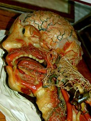
Some people find cross sections of human anatomy interesting, too. Maybe this is your first test in regards medical school. So you think you want to be a doctor, eh?
Map art: the reds & blues of the world ocean currents map
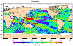
Ocean Surface Topography Mission/Jason 2 Begins Mapping Oceans
Originally uploaded by Ilusiones...no realidad...
Find one on p. 63 in the textbook. Or see physicalgeography.net.
- Render and label the continents and oceans.
- Sketch and color these currents:
1.California Current
2. N Equatorial Current
3. S Equatorial Current
4. Brazil Current
5. Gulf Stream / N Atlantic Current
6. Canary Current
hemi / sphere
Hemisphere (from Ancient Greek - hēmisphairion "half of a sphere") may refer to:
* Half of a sphere
As half of the Earth:
* Any half of the Earth or other planetary or stellar body
* New World
* Old World
* Western Hemisphere
* Eastern Hemisphere
* Northern Hemisphere
* Southern Hemisphere
* Land hemisphere
* Water hemisphere
As half of the brain:
* Cerebral hemisphere, a division of the cerebrum
* Half of the cerebellum, a smaller part of the brain
wikipedia.org.
Greenwich, England, lies upon the Prime Meridian
The Prime Meridian is the meridian (line of longitude) at which longitude is defined to be 0°, says Wikipedia.
The Prime Meridian and the opposite 180th meridian (at 180° longitude), which the International Date Line generally follows, form a great circle that divides the Earth into the Eastern and Western Hemispheres.
Unlike the parallels of latitude, which are defined by the rotational axis of the Earth (the poles being 90° and the Equator 0°), the Prime Meridian is arbitrary. By international convention, the modern Prime Meridian is one passing through Greenwich, London, United Kingdom, known as the International Meridian or Greenwich Meridian.
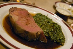
This is not the Prime Meridian
This may remind you of the Prime Meridian, but it is, in actuality, a cut of Prime Rib. It is a tender, flavorful cut of roast. Served au jus with a bit of horseradish and fried onion rings it is a sublime reminder of the imaginary line that runs through Greenwich, England.
One day I would truly like to consume a 12 oz. Prime Rib on the Prime Meridian. You, too?
One day I would truly like to consume a 12 oz. Prime Rib on the Prime Meridian. You, too?
Italian design: the 1950's shape of the Vespa motor scooter
How did we get to the graceful Vespa, whose name means "wasp?"
From Amerigo Vespucci, the explorer and cartographer (about 1500). Our continents are named for him.
How did we somehow integrate mention of Leonardo DiCaprio and the Isle of Capri (on the Italian, Mediterranean coast)? The island of goats?
Why, from the Tropic of Capricorn. Basic, my dear.

From Amerigo Vespucci, the explorer and cartographer (about 1500). Our continents are named for him.
How did we somehow integrate mention of Leonardo DiCaprio and the Isle of Capri (on the Italian, Mediterranean coast)? The island of goats?
Why, from the Tropic of Capricorn. Basic, my dear.
What are questions like on the open notes tests? A sample . . .
Queries that coordinate with your work in World Geography, pp. 5 - 11.
The basics!
1. Parallels are lines of a) latitude or b) longitude.
2. 40E is an example of a line of a) latitude b) longitude.
3. A line of longitude may also be termed a myrmidon. T / F
4. Tropic of Cancer: a) latitude b) longitude.
5. Prime meridian: a) latitude b) longitude.
6. Tropic of Capricorn: a) latitude b) longitude.
7. The equator: a) latitude b) longitude.
8. Map symbols such as cross-hatched lines, dotted lines, dashed areas, patches of color and shield-shaped items laden with numbers are explained in the __ __.
9. There are 4 pointed elements to this type of famous map graphic. Sometimes there are even more points. Additionally, this can be a colorful and decorative item. It is called a __ __ .
10. Pilots save expensive jet fuel by navigating a route called a __ __ __.
11. Another name for a map maker: __.
12. A slice or segment shaped in approximately triangular form - so that it can be fitted. It is called a __.
13. Most of the maps we encounter in daily life are probably in the category of: a) physical b) political c) so-called “breakfast” maps.
14. Sketch a cross-section map of CMHS, including the river. It will be rough, but OK for our purpose today.
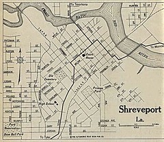
15. Latitude and longitude of Shreveport: __, __.
Next project: colorful map of the toiling tributaries of the Mississippi valley.
Independent project: geographic and economic profile of the Old Navy and Gap corporate empire.
The basics!
1. Parallels are lines of a) latitude or b) longitude.
2. 40E is an example of a line of a) latitude b) longitude.
3. A line of longitude may also be termed a myrmidon. T / F
4. Tropic of Cancer: a) latitude b) longitude.
5. Prime meridian: a) latitude b) longitude.
6. Tropic of Capricorn: a) latitude b) longitude.
7. The equator: a) latitude b) longitude.
8. Map symbols such as cross-hatched lines, dotted lines, dashed areas, patches of color and shield-shaped items laden with numbers are explained in the __ __.
9. There are 4 pointed elements to this type of famous map graphic. Sometimes there are even more points. Additionally, this can be a colorful and decorative item. It is called a __ __ .
10. Pilots save expensive jet fuel by navigating a route called a __ __ __.
11. Another name for a map maker: __.
12. A slice or segment shaped in approximately triangular form - so that it can be fitted. It is called a __.
13. Most of the maps we encounter in daily life are probably in the category of: a) physical b) political c) so-called “breakfast” maps.
14. Sketch a cross-section map of CMHS, including the river. It will be rough, but OK for our purpose today.
15. Latitude and longitude of Shreveport: __, __.
Next project: colorful map of the toiling tributaries of the Mississippi valley.
Independent project: geographic and economic profile of the Old Navy and Gap corporate empire.
America's largest crop: corn
America’s largest crop is corn, says Wikipedia.
Corn is a readily available, reliable, storable and versatile commodity. In the average American supermarket, corn derived ingredients can be found in one-fourth of everything on the shelves.[2]
This includes not only food items, but also cosmetics, toiletries, cleaning products and household goods. Aside from that, corn is also used for the feeding of factory farm animals, for the production of alcohol, and can be used as a fuel source for both heat production and vehicles. On top of being a versatile commodity, corn has been genetically modified in a way that facilitates industrial-agricultural harvesting and large yields.
Between the years 1920 and 1980, US corn yields increased 333 percent and continue to improve.[3] The strains of corn used for industrial farming are engineered to grow in a uniform, perfectly upright fashion that facilitates mechanical harvesting. Corn is also modified to thrive in crowded conditions; one acre of land can accommodate around 30,000 plants and produce roughly 180 bushels of corn, with each bushel weighing in at 56 pounds.[4] Genetic modifications have made it possible for certain strains of corn to be naturally insect resistant.
Cheap and readily available chemical pesticides and synthetic fertilizers have contributed greatly to high crop yields; corn has also been engineered to tolerate chemicals and to efficiently utilize petrochemical fertilizers.[5] Increases in the productivity of corn have helped to keep food prices low. America’s number one crop has an undeniably important place in both the economy and in peoples' diets.
Wednesday, August 20, 2008
Note-taking skills in social studies class
Recommended practice . . .
- Leaving generous space between items.
- Learning to shorten sentences and to use abbreviations.
- Using sketches to punctuate and illustrate items.
- Using color for accent.
- Underlining key words.
- Asking questions of the teacher when in doubt.
- Leaving generous space between items.
- Learning to shorten sentences and to use abbreviations.
- Using sketches to punctuate and illustrate items.
- Using color for accent.
- Underlining key words.
- Asking questions of the teacher when in doubt.
Rain hampers the local corn harvest; what are the implications?
This morning I talked with teacher Margaret Nance about her farm in Dixie. She said the August rains - ordinarily expected in September - were stopping the harvest. The harvester machines cannot work the fields when there is too much mud. She added that the farmers are under contract to deliver their crops at a certain time.
So I asked geography students to write a brief answer to the query "Rain hampers the local corn harvest; what are the implications?"
First, students wanted to know the definition of "implication." It is something that is not stated directly but something that is suggested.
The implications? The price of corn may rise. Many students smartly pointed out that supply and demand might cause the price increase.
Other students said that supplies of Ethanol, a fuel made from corn, might be affected. A few students pointed out that prices of beef and soft drinks and even ice cream might rise because these products are based partly on corn.
All things considered, it gave students a chance to use a higher level of thinking and their background in current events.
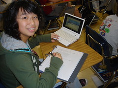
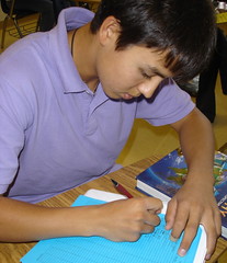
Implication? Studious, intelligent, careful
The truth of the matter is that I don't know whether Joseph is studious and careful. He was placed in my class only today. But something about this photo of him implies those qualities.
To imply is to suggest. One must interpret to draw an implication.
Today's question was -
"Corn harvest in Caddo upset by rain. What are the implications?"
Thus we are looking for the things that will happen in the overall marketplace as a result of this slowdown in harvesting this important grain.
To imply is to suggest. One must interpret to draw an implication.
Today's question was -
"Corn harvest in Caddo upset by rain. What are the implications?"
Thus we are looking for the things that will happen in the overall marketplace as a result of this slowdown in harvesting this important grain.
B&N, Amazon, Ebay: no problem getting a Rand McNally Quick Reference World Atlas
Barnes & Noble told me they're getting in a considerable quantity of the Rand McNally Quick Reference World Atlas, which is quite a bargain at $6.
Still, some students are ordering their copy from Amazon or Ebay.
Thanks for making this book a priority!
Under the cover of the book please print your name and phone and / or homeroom or E205/Trudeau. Losing the RMQRWA is not unusual; it can be returned efficiently if the student's name is there.

Still, some students are ordering their copy from Amazon or Ebay.
Thanks for making this book a priority!
Under the cover of the book please print your name and phone and / or homeroom or E205/Trudeau. Losing the RMQRWA is not unusual; it can be returned efficiently if the student's name is there.
Tuesday, August 19, 2008
CMHS Class of 2012 activities begin Fri, Sept 5
With a team of parents, students and teachers we will plan a slate of activities that will help energize the first-year group. Here are the plans so far . . .
1. Speed Meeting Night: Fri, Sept 5. Fun and getting-acquainted games in the cafeteria as witty emcees move all through a sort of Speed Dating routine.
2. Freshman Talent Show: auditions on Oct 2 and 3. Rehearsals all week, Mon,Oct 6, to Fri, Oct 10. Performance on Fri, Oct 10. It is about singing, dancing, comedy and team-building. Parents will be involved, too.
3. Planting crepe myrtles on the Cmhs campus during the school day.
Date to be announced. We will raise the money, purchase the small trees, bring shovels and plant the saplings on the campus.
4. Homecoming dance and supper. To be announced.
Meeting for freshman committee activities parent group set for Mon, Aug 25, 7 pm
Mrs. Barbara Meyers is hosting a freshman committee activities meeting Mon, Aug 25, 2008, at 7:00 p.m.at her home, which is located at 660 Elmwood, Shreveport 71104. It is on the corner of Elmwood and Dillingham fairly close to Byrd High.
Barbara says, "The meeting should not last more than an hour but is important and if you know of ANY other freshman parents who can come to the meeting and want to volunteer please invite them. If you have any questions please call 422-4771 or email meyerstennis@bellsouth.net."
Barbara says, "The meeting should not last more than an hour but is important and if you know of ANY other freshman parents who can come to the meeting and want to volunteer please invite them. If you have any questions please call 422-4771 or email meyerstennis@bellsouth.net."
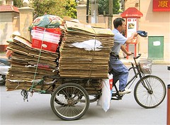
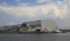
Recycling comes to Shreveport via the Red River
Pratt Industries has broken ground on construction of its third, 100% recycled containerboard mill, says the Pratt Industries web site. The facility, located in Shreveport, La., will open in late 2008, and will eventually produce more than 360,000 tons of recycled paper a year to supply the company's growing internal demand for more paper.
It will also create more than 115 full-time jobs on site, while state officials estimate almost 1700 new jobs, direct and indirect, will be created during the construction phase.
"This mill symbolizes our continued commitment to growth for our company, for our customers and for the paper/packaging industry," said Chairman and CEO Anthony Pratt. "This means quality manufacturing jobs for Americans."
The Shreveport machine, which will be arrive in June, is being designed by the Italian group, Overmechanica. It will be committed to using 100% post-consumer fibers as do Pratt's other two mills in Conyers, Ga., and New York City.
And Louisiana officials are thrilled the company is coming to the state. Outgoing governor Kathleen Blanco said: "Pratt's strong stance on environmental protection makes them a great fit with Louisiana. This 'green' investment will significantly enhance the conservation of our natural resources."
The new mill will make lightweight and medium line on a 220-inch trim, fourdrinier paper machine.
Pratt also plans to roll out a recycling program throughout the region to help supply the mill's fiber needs.
Donna Curtis, Shreveport Green, will speak to 8:30 geography class on Thurs, Aug 28 about recycling and Pratt Industries
Donna Curtis, spokesperson for Shreveport Green, will speak to students and parents about Pratt Industries and Shreveport's recycling program.
She will speak in E205 Thurs a week, which is Aug 28.
Parents are welcome!
I will videotape the presentation for the instruction of my other geography classes.

She will speak in E205 Thurs a week, which is Aug 28.
Parents are welcome!
I will videotape the presentation for the instruction of my other geography classes.
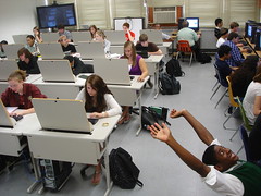
View from teacher's laptop: student laptops in class are recomended
Students are encouraged to bring laptops to class in this geography class. The typical work will be -
- taking notes.
- following my web site presentations.
- looking up vocabulary.
- referencing maps.
- composing answers to in-class questions.
Guidelines include
- stay on academic tasks or forfeit usage.
- angle screen toward teacher at all times.
- no quick switching of screens as teacher approaches.
Most of my students say they have high speed internet
We seem to be an affluent community; some 93% of my students claim to have access to high speed internet.
Ask your parents about the cost of internet access per month, please.
What happens to you and your school work if your internet access is interrupted? We went over this in class.
The school library will be your savior.
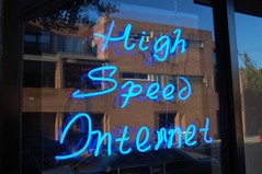
Ask your parents about the cost of internet access per month, please.
What happens to you and your school work if your internet access is interrupted? We went over this in class.
The school library will be your savior.
We get the name of the month of August from Augustus Caesar
Thus part of our calendar is dominated by Mediterranean, Roman and latin cultures.

What was the state of the Red River in 1812?
The American rivers were still difficult to navigate, however, because of the presence of dead wood called snags, sawyers [1], or log jams, says Wikipedia.
Henry Miller Shreve was appointed Superintendent of Western River Improvements in 1826 and charged with finding a solution to this problem. He had been working on a design for a "snagboat" since 1821, and he finally had it built in 1827. This craft, the Heliopolis, had a steam-powered windlass used to pull large concentrations of dead wood from the water. As a result of the success of his design, Shreve was ordered in 1832 by Secretary of War Lewis Cass to clear the Great Raft, 150 miles of dead wood on the Red River.
Shreve successfully removed the Raft (despite inadequate funding) by 1839. The area of the Red River where the Raft was most concentrated is today his namesake city of Shreveport. Shreve helped to establish Shreveport via the Shreve Town Company. In 1841, Shreve was relieved of his superintendent's duties by the nominally Whig U.S. President John Tyler. He hence retired to his farm near St. Louis.
Red River valley sketch project due Friday
- Sketch a map of NM, Tx, Ar, Ok and La.
- Using color, draw the route of the Red River.
- Add a bit of the Miss R.
- Label the states.
- Label 3 cities: Amarillo, Spt-Bossier, Alexandria.
- Add a colorful title at the top of the page.
- 6 pts.

- Using color, draw the route of the Red River.
- Add a bit of the Miss R.
- Label the states.
- Label 3 cities: Amarillo, Spt-Bossier, Alexandria.
- Add a colorful title at the top of the page.
- 6 pts.
Dates such as 2008 AD being changed to 2008 CE
Anno Domini, "in the year of our Lord," is being phased out by many sources, to be replaced by the term CE, "in the common era." CE is seen as less culturally biased by people who are not Christian. The companion term will be BCE, "before the common era."

Pratt Industries Paper Recycling Plant enables Shreveport to have recycling collection
In 2007 one of the world's big paper recycling companies, Pratt Industries, located a plant at the Port of Spt-Bossier - on the Red River.
It is a contract w Pratt Industries that allows the city of Shreveport to have a curbside recycling program.
Pratt recycles the paper goods. It sells the glass, plastic and metal to other companies.
Pratt uses the Red River for cheap transport.
Maybe one day you will create a recycling facility. Either that or we'll end up like the people in the movie Wall-E.
Parent signature by Friday on web site address
Make sure your parents know the address of the class web site. It will be a great thing when we're all on the same page.
Mondo! the world of .. . Trudeau! your teacher . . .
Mondo! the world of .. . Trudeau! your teacher . . .
Monday, August 18, 2008
Demographics: World Population
The demographics of first year students at CMHS, the Class of 2012, encompasses some 15 middle schools. While a large number of our students come from CMM, in many classes the majority of students are from many different middle schools.
Therefore, there's a great need for making new friends.
Demographics is the study of populations. How many students at CMHS are age 14? How many age 16?
The demographics of the city of Shreveport are currently painful. Shreveport's population is shrinking, according to Census reports as published in the Times. We have slipped below the 200,000 mark. Therefore, the student population of Caddo schools is shrinking.
When we look at demographics, we see statistics. But the key to using demographics is in the interpretation of those facts. The value lies in finding trends.
Create a personal history map
Your teacher's personal history map includes
a) Fall River, Mass
b) Napoleonville, La (Bayou LaFourche)
c) Covington, La
d) New Orleans (University of New Orleans)
e) Shreveport
If you were born and raised in Shreveport, you must list the neighborhoods in which you've lived or the schools you've attended.
Your map of Shreveport should include the Red River, i-20, downtown, and CMHS.
Students who have lived in other states and nations should include simple maps of those locations.
Materials required for world geography / Trudeau at CMHS
Caddo Magnet High School / World Geography
Robert Trudeau / trudeau@earthlink.net / 861-1519
Welcome to World Geography at CMHS
Two sites for parents and students to follow:
* CaddoMagnet.net
* Mondotrudeau.blogspot.com
At mondotrudeau you will find class requirements, assignments, reviews and links to more detailed reading.
* Plan your week by viewing mondotrudeau each Sunday afternoon. You will see an outline of the week’s activities.
* Thursdays are the day for essays, tests and project deadlines.
** Required atlas: Rand McNally Quick Reference World Atlas ($6)
Easy to carry (bring it to class every day); inexpensive. Please do not substitute. Available at Barnes & Noble, other stores and also at Amazon.com.
** Fee: $5, payable to Caddo Magnet High School. Defrays cost of field trips and special materials.
** Scissors (small), colors (map pencils, crayons or pastel markers)
** Notebook must feature a) pages with perforated edges b) pockets for handouts.
** Please submit a standard-size sheet of paper with parents’ or guardians’ names, address, all phone numbers.
Subscribe to:
Posts (Atom)
