Patagonia is a geographic region containing the southernmost portion of South America, says Wikipedia.
Located in Argentina and Chile, it comprises the southernmost portion of the Andes mountains to the west and south, and plateaux and low plains to the east. The name Patagonia comes from the word patagón[1] used by Magellan to describe the native people whom his expedition thought to be giants.
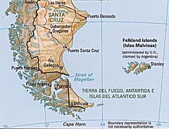
Santa Cruz is the largest province in the Argentinan Patagonia and the largest political subdivision in the region as a whole, covering 293,993 km2.
The province, mostly a cold, windswept steppe, is well-known for its extensive pebble beaches as well as for the deep-water lakes and vast glaciers in the Andes foothills along its western border with Chile. Santa Cruz's Atlantic coast is also known for the Laguna del Carbón; lying 105 meters (330 ft) below sea level, it is the lowest geographic point in the Western Hemisphere.
One of Santa Cruz's best-known geological curiosities is its Jamarillo Petrified Forests National Monument. Incorporated into the national park system in 1954, the 137 square kilometre (35,000 acre) area includes one of the world's most significant remains of Jurassic-era forests. The National Parks Administration also acquired 600 square kilometres (150,000 acres) of neighboring land, creating the largest natural steppe preserve in Latin America.
Santa Cruz's most notable and most visited geographic feature, however, is probably Perito Moreno Glacier, a national park as well.
skip to main |
skip to sidebar
For students and parents who love education and exploration of the social sciences . . .
Search This Blog
Followers
Blog Archive
-
▼
2009
(379)
-
▼
November
(30)
- TE Lawrence: a study of the meeting between Europe...
- Enriched geography requirements: one book per seme...
- European connections to the Caribbean
- Magnet 2013 Crepe Myrtle Planting successful: 30 t...
- Jamaicans created rock steady and ska as well as r...
- Rastafarians: a recent religious group born in Jam...
- Jamaican singer-songwriter Bob Marley, 1945 - 1981
- Roda de Capoeira: an Afro-Brazilian dance/sport th...
- Tues: bring shovels; Thurs: crepe myrtle planting day
- Wed, Nov 18: Caribbean map & open notes quiz
- One of Brazil's many rock bands, Sepultura has sol...
- US has held an embargo against Cuba for 47 years -...
- Map quiz: sketch and identify continents, nations ...
- Once Upon A Mattress: a comedy from Magnet Drama a...
- Comparing Caribbean Islands to archipelagos on oth...
- St. Croix, the US Virgin Islands
- San Juan, capital of the Commonwealth of Puerto Rico
- American mogul Bill Gates, "world's wealthiest man...
- Prince Henry the Navigator, a Bill Gates of the 14...
- Yerba mate: the ritual drink of Argentina and much...
- Homework in Geography / Trudeau: Read web site not...
- Trinidad: Caribbean island with the largest of all...
- 600 miles into the Pacific lies the Ecuadorian arc...
- Plan to eat well at the Homecoming picnic on Friday
- Valuable but endangered: the Amazon basin
- Environmentally-focused California clothing compan...
- Social Studies Fair Project guidelines reminder
- At the southernmost tip of the Western continents:...
- Mapa antiguo de América del Sur, me hearties!
- Rio de Janeiro, Sao Paulo and Brazil: this week's ...
-
▼
November
(30)
