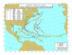
Student maps should be spread across 2 notebook pages (N & S Amer on the left, Europe & Af on the right). Include the outlines of the following land masses:
Western Europe
West Africa
S America
Central America
N Amer
Cuba (separates the Caribbean from the Gulf)
Atlantic
Caribbean
Gulf of Mexico
Ocean currents:
- N and S Equatorial
- N Atlantic
- Gulf Stream
- Canary
Equator
Prime Meridian
Tropics
40N, 40S and 50W, 2E
Use color.
Add a title.
skip to main |
skip to sidebar
For students and parents who love education and exploration of the social sciences . . .
Search This Blog
Followers
Blog Archive
-
▼
2010
(346)
-
▼
August
(27)
- Quiz on the background of the Caddo peoples
- Project on the Five Themes of Geography as they ap...
- In-class project: Atlantic storm tracking map
- Basics of geography: the projections used in const...
- Open notes, multiple choice quiz on Th/Fr: identif...
- Mississippi valley map quiz Tues/Wed: 15 pts on me...
- Holistic teaching: kinesiology, oxygenation and st...
- Fifth anniversary of the flooding of New Orleans a...
- Spaceship earth: teaching and using the system of ...
- Indigenous peoples: the original inhabitants
- What does a Hydrologist do?
- Fruit or nuts as a school day snack, rather than c...
- Mimal & Wiktm and mnemonics
- Spaceship Earth teaching project
- Notes on population, Ramadan and coordinates
- The implications of 6.8 billion people
- Enrichment reading: the history of navigation
- Multiple choice, open notes test: first quiz in ge...
- World geography project: latitude & longitude revi...
- World Geography additional text: The 2009 World Al...
- What's for lunch this week: Pimento Cheese sandwich
- Out of print: the long-valued Rand McNally Quick R...
- "Caddo:" what's the background of the name of this...
- Looking historically at the name "Caddo" - a diagn...
- Class of 2014 Talent Show performance night schedu...
- Water Bottle represents an industry that is far fr...
- US no longer leads in college degrees, ages 25 to ...
-
▼
August
(27)
