On Sun, Dec 7, 1941, the US lost some 15 ships and over 2000 sailors when a Japanese air attack hit the US Naval base at Pearl Harbor.
For the previous 10 years the Japanese had been building an empire in East Asia. They had taken over Indonesia, Indochina, including Vietnam, and part of China. The military government of Japan had convinced the emperor that buildling an empire was appropriate.
There were numerous indications that the Japanese might attack the US in the Pacific.
************
Infoplease.com says, " First settled by Polynesians sailing from other Pacific islands between A.D. 300 and 600, Hawaii was visited in 1778 by British captain James Cook, who called the group the Sandwich Islands.
Hawaii was a native kingdom throughout most of the 19th century, when the expansion of the sugar industry (pineapple came after 1898) meant increasing U.S. business and political involvement. In 1893, Queen Liliuokalani was deposed, and a year later the Republic of Hawaii was established with Sanford B. Dole as president. Following annexation (1898), Hawaii became a U.S. territory in 1900."
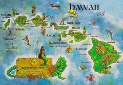
Hawaiian map identifications -
1. Pearl Harbor
2. Honolulu
3. Oahu Island
4. Maui Island
5. Hawaii Island
6. Mauna Loa & Mauna Kea Mtns.
Population about 1.2 M.
Says Wikipedia.org, "Hawaii may be an especially healthy place to live. Hawaiians born in the year 2000 can expect to live 79.8 years (77.1 years if male, 82.5 if female), longer than the residents of any other state.[12] Mississippi came in 50th, living 73.6 years (70.4 male and 76.7 female), but the District of Columbia was dead last, living 72.6 years (68.5 male and 76.1 female)."
skip to main |
skip to sidebar
For students and parents who love education and exploration of the social sciences . . .
Search This Blog
Followers
Blog Archive
-
▼
2006
(381)
-
▼
December
(50)
- Expanding our consciousness in Iraq, from the Econ...
- Second semester overview: from the Land of the Ris...
- Camera for Xmas?
- Sample test on the life of Gandhi
- October test / Israel & Arabia with answers
- China review and Essay skills
- Sem Exam: notes from Oct, Nov, Dec
- The list of Chinese inventions is astounding to a ...
- Chinese architecture project - apartments, farmers...
- The Pekingese and the many breeds that originated ...
- Second semester project: making a Chinese dragon f...
- Spiritual head of Tibetan Buddhists, the Dalai Lama
- Aquaculture, another similarity between China and ...
- School drop-outs: do we share the problem with China?
- 101 Tapei: the world's largest steel orb inside th...
- Hawaii & Pearl Harbor: basic background
- 10,000 watch towers, 4,000 miles: the Great Wall
- 8000 life-size figures in the Terra Cotta Army of ...
- Mao Zedong, communist dictator of China from 1949 ...
- House of Flying Daggers was a pop martial arts mov...
- Watching a modern story of China in Mandarin Chine...
- Semester exam: 100 mult-choice questions answered ...
- Ni hau! That's the world's most widely spoken form...
- Why study China: WalMart, US Army, Guitars, Outsou...
- Brief unit on the basics of Washington DC
- Objective accomplished: Class of 2010 Talent Show 06
- Brooke Hightower
- Set design & production: Mason Nabors
- Claire Crosby
- Rachel Young
- Talent show produced by first-years: Caroline Germany
- Doug Pierce & Caroline Germany
- Mac Orchard, lights, Amanda Hock & Eric Coleman, s...
- Alyssa, Diana, Lizzie
- Kaylah, Megan, Mason
- Kaylah Williams, Mason Nabors
- Katy Li
- Andrew Delo, Mason Nabors
- Michelle Khare
- Meredith & Maggie
- Matt Light vs. Andrew Delo
- John Henry Crawford, Arvesh Kompelli
- Kaitlin Williams
- Susan & Diana upon Canon in D
- Fabs, Michelle, Matt, Alyssa, Phillipe, Katy
- Liz Burford, Claire Cook, Maggie Caruthers on top
- Susan Beresko, Megan Shay, Hali Kha
- Maggie Caruthers, Meredith Cupp
- Thanks to veryone who attended and worked on the F...
- Tyler Snelling: Thai curry chicken
-
▼
December
(50)
