Sunday, September 30, 2012

Coming soon from Moonbot Studios, Shreveport: the Guardians of Childhood and Diggs Nightcrawler plus a Wm Joyce book signing at B&N on Sun, Oct 7, 3 pm

Rolling out Nov 21 is the DreamWorks film “Rise of the Guardians,” based on William Joyce’s book series, “The Guardians of Childhood.” Joyce was the executive producer on the movie, says digitaljournal.com.

The Guardian books feature childhood icons like Santa Claus, the Sandman, the Easter Bunny, and the Man in the Moon, and will be available through Simon and Schuster.

The next Moonbot app release comes early next year with “Diggs Nightcrawler” for the new Sony PlayStation 3 Wonderbook platform. The film noir-style tale follows a bookworm detective as he tries to solve the murder of Humpty Dumpty.

Moonbot Interactive Creative Director Adam Volker says it involves a book, the Sony PlayStation platform, and a special camera to animate the book interactively on a video screen. The Nightcrawler character actually digs through the book with interactive help from the reader.

There's also a new app called Imag.N.O.Tron to go with The Fantastic Flying Books of Mr. Morris Lessmore.

Flying out to the world's digital marketplace from their origination point of Shreveport, Louisiana.


A last minute update: William Joyce will have a hometown book signing to celebrate The Sandman and Toothiana on Sunday, October 7 at 3PM at Barnes & Noble.

Saturday, September 29, 2012

America Before Columbus: a view of the New World that is fresh andthought-provoking

"The South American potato helped spark a population explosion in Europe."

There are numerous, startling revelations to be found in the National Geographic documentary "America Before Columbus."

Friday, September 28, 2012

Comparing basic demographics of La, Tx and Connecticut; due 10.2-3, 15pts

Caddo Magnet Class of 2011    m  by trudeau
Caddo Magnet Class of 2011 m , a photo by trudeau on Flickr.

You are the CEO of a small company. State the name of the company in such a way that I can tell what sort of business it is. Example: Martin Diabetic Services, Inc. Williams Physical Therapy. Tremaine
Dance School, Inc. Van Gogh Financial Advisers, Inc. Titanic Ship Construction, Inc.

You are considering relocating to Texas or, in a radical possibility, to Connecticut.

Your first level of research - to be presented to your executive team - is a basic demographic background of the 3 states (incl La).

Please make colorful, neat graphs - either digital or handmade - that show these comparisons -

% of people with high school diploma.
% of pop. w bachelor's degree.
% of residents who fall below the poverty line.

Because America's population is changing, an ethnic analysis might be useful -
% of Caucasian.
% of Af-Amer.
% Asians
% Hispanics.

Amount of growth can be a consideration.
Show the totals and the % of change in population for each state. You may use 2011 or 2012 and may begin with 2000 or 2010. Do the math!

Your executives will expect a summary statement. In 3 sentences tell them which state you've chosen and explain the factors - from your graphs - that influenced your decision.


- Neat printing of labels. - Colorful bar or pie graphs. - Smart title. - Name, date, block in upper right. - Completed in notebook.

Thursday, September 27, 2012

Queen of Los Angeles

Magnet geography Los Angeles by trudeau
Magnet geography Los Angeles, a photo by trudeau on Flickr.

LA's full name:
The town of Our Lady (mother of Jesus in Roman Catholic parlance), Queen of the Angels of the River Porciuncula.

Notes -
- Watts Towers - primitive art by an Italian immigrant in a neighborhood that became a major Af-Am ghetto.

ghetto: Italian word which means "the section where the Jews live." Jewish ghettos in Europe existed because Jews were viewed as alien due to being a cultural minority and due to their non-Christian beliefs in a Renaissance Christian environment, says Wikipedia.

- Rodeo Drive - posh shopping district.
- RMS Queen Mary, retired steam liner twice the size of the Titanic.
- Disneyland dates from 1955.
- LaBrea Tar Pits: Asphaltum or tar (brea in Spanish) has seeped up from the ground in this area for tens of thousands of years. Over many centuries, animals that came to drink the water fell in, sank in the tar, and were preserved as bones. Ex: mammoths, sloths and saber-toothed tiger.
- Hollywood Hills: an affluent and exclusive neighborhood in the Santa Monica Mountains. By 1915 the movie business had largely relocated here from NYC.
- Chinatown Los Angeles
- Venice Beach & Boardwalk: people watching and trendy shopping.
- The J Paul Getty Museum and LA County Museum of Art: major art centers.
- Warner brothers Studios: take a tour!
- Beverly Hills: a posh municipality next door to Bel Air, Holmby Hills and West Hollywood.
- Marina Del Rey: major yacht harbor near LAX and Venice.
- Knott's Berry Farm: famous theme park.
- LA Farmer's Market: The most famous such market in the US.
- Walt Disney Concert Hall: radical building housing a center for orchestral music. Design is by LA architect Frank Gehry.
- Malibu: 27 miles of beaches; a celeb-studded coastline.

"Southern California saw a huge surge in palm tree plantings during the 1920s and 1930s, many of which still line L.A. streets today," says LA Almanac.

Wednesday, September 26, 2012

Outdone only by NYC and Tokyo in money power: the Pacific rim metroplex of Los Angeles

Magnet geography: Los Angeles by trudeau
Magnet geography: Los Angeles, a photo by trudeau on Flickr.

Los Angeles is the most populous city in California and the second most populous in the United States, after New York City,says Wikipedia.

The city is the focal point of the Los Angeles-Long Beach-Riverside combined statistical area, which contains nearly 17.8 million people and is the second largest in the United States.

The Los Angeles combined statistical area (CSA) has a gross metropolitan product (GMP) of $831 billion, making it the third largest economic center in the world, after the Greater Tokyo and New York metropolitan areas.

The original name: Nuestra Señora la Reina de los Ángeles del Río de Porciúncula (Our Lady the Queen of the Angels of the Porciúncula River).

The Los Angeles coastal area was first settled by the Tongva or Gabrieleños and Chumash Native American tribes thousands of years ago.

Los Angeles was founded in 1781 by Spanish governor Felipe de Neve. It became a part of Mexico in 1821.

In 1848, at the end of the Mexican–American War, Los Angeles and the rest of California were purchased as part of the Treaty of Guadalupe Hidalgo, thereby becoming part of the United States. Los Angeles was incorporated in 1850.

Los Angeles enjoys a Mediterranean climate, with an average of 35 days with measurable precipitation annually.

Los Angeles is subject to earthquakes due to its location on the Pacific Ring of Fire. The geologic instability has produced numerous faults, which cause approximately 10,000 earthquakes annually.[44] One of the major faults is the San Andreas Fault. Located at the boundary between the Pacific Plate and the North American Plate, it is predicted to be the source of Southern California's next big earthquake.

Public art in Chicago and Shreveport

P1030966 by trudeau
P1030966, a photo by trudeau on Flickr.

The Empire State Bldg is taller but the Chrysler Bldg is the more stylish of the two

P1030964 by trudeau
P1030964, a photo by trudeau on Flickr.

Silver cladding and seven Art Deco arches mark the style-conscious Chrysler Bldg.

Public art is like a winning football team; it makes people feel good about their community

Chicago Picasso by Aldenar
Chicago Picasso, a photo by Aldenar on Flickr.

In public art Shreveport has a 6-story mural called "Once Upon A Millennium Moon." It covers 2 sides of a downtown building that can easily be seen by people on I-20. It is a point of pride for Shreveporters. Makes us look good.

Chicago has 2 very famous pieces of public art: the 50 foot-tall Chicago Picasso downtown steel sculpture and the highly reflective, bean-shaped steel sculpture at Millennium Park called Cloud Gate.

Shreveport also has a guitar-playing sculpture on Texas St that is a likeness of Leadbelly, a man called the "father of American fold music." Leadbelly is internationally-known and honored.

Tuesday, September 25, 2012

N Y C / geography Magnet

N Y C / geography Magnet by trudeau
N Y C / geography Magnet, a photo by trudeau on Flickr.

NYC review
1. Name the island that has 2 boroughs.
2. Name the 5 boroughs of NYC.
3. Name the most densely-populated borough, which is the central island.
4. Name the southerly island borough.
5. Name the river on the west side of NYC.
6. Name the ocean adjacent to NYC.
7. Name the 2 states that are closest to NYC.
8. Name the 3 islands that surround New York harbor.
9. Name the 2 famous small islands in NY harbor. One has a museum of US Immigration, one bears a giant statue.
10. The body of water that separates Long Is and Connecticut has an archaic name: Long Island Sound (bay).

Monday, September 24, 2012

An architectural stand-out: Regions Bank, 333 Texas St, Shreveport

Looking up to the sky by rpcurrey
Looking up to the sky, a photo by rpcurrey on Flickr.

In 1997 Regions Bank was renovated. As you can see, a sharp, black new eruption emerged from the basic and plain 1933 original structure.

This 16-story bank and office center is your teacher's favorite building. Outside of the tent-like Sportran Terminal on Crockett St.

One World Trade Center, aka Freedom Tower, rises in Lower Manhattan

One World Trade Center, more simply known as 1 WTC and previously known as the Freedom Tower, is the lead building of the new World Trade Center complex in Lower Manhattan, New York City.

The 104-story business center is in the northwest corner of the 16-acre World Trade Center site, occupying the location where the original 8-story 6 World Trade Center once stood.

At the time of its completion in 2013, One World Trade Center will be the tallest building in the Western Hemisphere and the third-tallest building in the world by pinnacle height. Its spire will reach a symbolic 1,776 feet.

A museum and memorial will occupy the site of the Twin Towers.

Empire State and Chrysler Bldgs built at the end of the Roaring 20's and beginning of the Great Depression

Geography - Chrysler Bldg by trudeau
Geography - Chrysler Bldg, a photo by trudeau on Flickr.

At the end of the Roaring 1920's and the beginning of the Great Depression these two beauties were erected.

The Roaring Twenties is a term for the 1920s, characterizing the era's distinctive cultural edge in most of the world's major cities for a period of sustained economic prosperity. "Normalcy" returned to politics in the wake of hyper-emotional patriotism during World War I, jazz music blossomed, the flapper redefined modern womanhood, and Art Deco peaked, says Wikipedia.

The Great Depression was a severe worldwide economic depression in the decade preceding World War II, says Wikipedia. The timing of the Great Depression varied across nations, but in most countries it started in 1930 and lasted until the late 1930s or middle 1940s.[1]

It was the longest, most widespread, and deepest depression of the 20th century.

Cane River author Lalita Tademy speaks at Caddo Magnet High on Thurs,Oct 4, 6:30 pm, in Performing Arts Center

Historical novelist Lalita Tademy will speak at Caddo Magnet HS in the annual Mary Jane Malone Series, says Kris Clements.

Tademy will speak to Caddo Magnet students after lunch and in conferences on Thurs, Oct 4.

At 6:30 pm Tademy will speak to the public in the Caddo Magnet PAC. No charge.

Tademy is a NY Times bestseller author. Her 2001 book, Cane River, was an Oprah Book Club choice.


Having recently read Cane River, I can give it a high recommendation. Tademy combines historic research - she did years of reading before doing her writing - with a canny sense of social dynamics - racism in all the 100 variations - and emotion.

Sunday, September 23, 2012

Compare the Empire State Bldg to the Chrysler Bldg

chrysler bldg 1 by trudeau
chrysler bldg 1, a photo by trudeau on Flickr.

Built as the US plunged into the Great Depression, the Chrysler Building (1930) and Empire State Bldg (1931) are graceful parts of old NYC.

Your teacher's favorite is the Chrysler.

Then there's the new One World Trade Center.

At the time of its completion in 2013, says Wikipedia, One World Trade Center will be the tallest building in the Western Hemisphere and the third-tallest building in the world by pinnacle height, with its spire reaching a symbolic 1,776 feet (541.3 m) in reference to the year of American independence.[11][12]

Thursday, September 20, 2012

Tuesday, September 18, 2012

Geography: Rastafari, map quiz, Columbus, Caribs

The Carib is sweating profusely because he is dying of the viral diseases that decimated indigenous peoples after the arrival of the colonial men.

Indigenous tribes:
Carib
Tainos
Arawak

Aruba: one of 6 Dutch islands in the Carib

Aruba Boats & Pelican by msprago
Aruba Boats & Pelican, a photo by msprago on Flickr.

Dutch islands in the Caribbean

Aruba
Curaçao
Sint Maarten (the southern half of the island of Saint Martin).
Bonaire
Sint Eustatius
Saba.

Iguana meat! and a quiz

Iguana meat! by videsent
Iguana meat!, a photo by videsent on Flickr.

In Central and South America the iguana is prized for its meat.

Jerk chicken review
1. Name an island on which English is a principal language.
2. Name an island on which French is a principal language.
3. Name an island on which Spanish is a principal language.
4. Name an island on which Dutch is a principal language.
5. Hispaniola is an __ .
6. The Cayman islands were named for a creature that is more or less an __.
6/7. Venezuela, Colombia, Panama, Nicaragua and Mexico do not seem to be Caribbean nations. They are too far from the principal islands of Cuba and Hispaniola to be classified as Caribbean nations. T / F

Monday, September 17, 2012

Interactive learning / Caribbean pop-up map /

On your participatory pop-up map of the ancient Carib lands, please include -

- Yucatan peninsula
- Florida
- Cuba
- Jamaica
- Haiti
- Dominican Rep.
- Puerto Rico
- Trinidad
- the Lesser Antilles
- Venezuela
- Gulf of Mexico
- Caribbean
- Atlantic
- and a sloop

- Word bank on the side or back of the page.

Interactive (pop-up) Caribbean map and the Jerk Chicken review

Jerk chicken review
1. Name a Caribbean island on which English is a principal language.
2. Name an island on which French is a principal language.
3. Name an island on which Spanish is a principal language.
4. Name an island on which Dutch is a principal language.
5. Hispaniola is an __ .
6. The Cayman islands were named for a creature that is more or less an __.

Sunday, September 16, 2012

Pop-up Caribbean map project

Caribbean_general_map by trudeau
Caribbean_general_map, a photo by trudeau on Flickr.

In-class, hands-on activity . . .

A) With scissors, clip out the shapes of the major locations in the Caribbean. Each island should have a rectangular tab included in the cut. This will become a hinge for the pop-up when it is glued to the page.
b) Make sure each shape is colored but does not bear a name.
c) Archipelagos made of many small islands can be cut out in lengthy blocks. Ex: the Bahamas and the Lesser Antilles.
d) Write the identification for each location under the shape. That way someone can see the colorful, blank shapes as a quiz. When they pick up the hinged island
they will see the name of the location.
e) On the side of the page, make a word bank.

For indie work, you may teach a brief lesson on the Caribbean to a classmate or sibling or parent. Refresh them via a study guide map or your atlas. Then let them use the pop-up map as a test.

In a brief essay give the name and profile of the people taking the quiz and their overall performance.

Please include
- Yucatan peninsula
- Florida
- Cuba
- Jamaica
- Haiti
- Dominican Rep.
- Puerto Rico
- Trinidad
- the Lesser Antilles
- Venezuela
- Guld of Mexico
- Caribbean
- Atlantic

Thursday, September 13, 2012

Louisiana is second most impoverished state, says the US Census Bureau

WASHINGTON — The U.S. Census Bureau reports the number of Americans in poverty stood at 15 percent in 2011.

About 46.2 million people, or nearly 1 in 6, were in poverty. That is not statistically different from the 15.1 percent who were impoverished in 2010.

Broken down by state, New Mexico had the highest share of poor people, at 22.2 percent, according to rough calculations by the Census Bureau.

It was followed by Louisiana at 21.1 percent with about 947,000 residents living below the poverty line. The median income for Louisiana residents is about $40,658 a year, according to the report. That's lower than all but three states: Kentucky, South Carolina and Montana. Nationally, the median income is about $50,000 a year.

Presentations due 9.20-21.12: choose from Chicago, Los Angeles or NYC

chicago bean by tater48gem
chicago bean, a photo by tater48gem on Flickr.

These presentations represent an exploration, an overview of the city you've chosen. Follow your teacher's priorities - demographics, economic (business) successes - and develop your own material.
Use
- four images from the city, each accompanied by 3 factoids.
- city map slide.
- documentation: at least 3 sources.
- bulleted info.
- Clever title.

Christopher Columbus' Tomb in Seville Cathedral, Spain

Hispaniola quiz 9.12-13.12
1. Name the nation that lies between Cuba and the Dominican Republic. __
2. Which island is the largest US Territory in the Caribbean? __ __
3. Which is the only consecutively-doubled letter in the name of the great sea bounded by the Greater Antilles, the Lesser Antilles and the coasts of Central and South America? __
4. This nation lies south of Cuba and west of Haiti: __ .
5. This island nation is adjacent to the coast of Venezuela: __ .
6. This Kenyan city lies at 1S, 36E: __ .
7. The capital of Indonesia is the center of a megalopolis of some 26 million people. It is Jakarta. Write its coordinates.

Wednesday, September 12, 2012

Earth currents / Gulf Stream quiz

Earth currents. by doneastwest
Earth currents., a photo by doneastwest on Flickr.

Gulf Stream quiz
1. Columbus was not the first European to voyage to the New World. T / F
2. The capital of the Bahamas: __ .
3. Atlantic islands about 600 miles east of the South Carolina / Georgia border: __ .
4. Caribbean sea snail: __ .
5. Word for a sailboat race: __ .
6. Linking a tale about impoverished island kids with BB guns to the Caribbean is part of a learning or memory strategy called a __ .
7. In Jamaica people mostly speak English or a patois. In the Dominican Republic the language is Spanish. In Haiti the dominant language is __ .

Tuesday, September 11, 2012

Sailing in the social studies: know the basic parts of a sloop

SAILBOAT_DIAGRAM by trudeau
SAILBOAT_DIAGRAM, a photo by trudeau on Flickr.

Sloop:
- hull (body of boat)
- single mast
- boom
- mainsail
- jib
- keel
- rudder
- tiller or wheel

Starboard and port
bow and stern


Sailing is a slow sport (raising and lowering sails, etc) but deeply in touch with nature. It is mostly a sport of the wealthy class. But, of course, anyone can sail.

Some sailors love the silence and purity of this mode of transport, others love the aeronautical study that can accompany a deep understanding of the sailing process.

Learn sailing on Cross Lake amidst lots of sloops at the Shreveport Yacht Club.

Monday, September 10, 2012

Cristobal Colon, aka Christopher Columbus: four voyages over some 12 years

The voyages of Columbus initiated European colonization of the American continents, and are thus of great significance in world history, says Wikipedia.

Christopher Columbus was a navigator and an admiral for Castile, a country that later founded modern Spain.

He made four voyages to the Americas, with his first in 1492, which resulted in what is widely referred to as the Discovery of the Americas.[2]

The discovery of the Americas has variously been attributed to others. For example, the Vikings (c. 1000) had previously established a settlement at L'Anse aux Meadows, Newfoundland.

While Columbus was not the first European to voyage to the New World and did not actually reach the mainland until his third voyage in 1498 (when he reached South America, and the fourth voyage, when he reached Central America), his discoveries led to the major European sea powers sending expeditions to the New World to build trade networks and colonies and to convert the native people to Christianity.

Columbus died an unfulfilled man. About 1500 the king and queen fired him as colonial governor because he insisted on enslaving and killing indigenous peoples.

Beware the Bermuda Triangle, a region of nefarious Urban Legend

The Bermuda Triangle, also known as the Devil's Triangle, is a region in the western part of the North Atlantic Ocean where a number of aircraft and surface vessels are said to have disappeared under mysterious circumstances, says Wikipedia.

Popular culture has attributed these disappearances to the paranormal or activity by extraterrestrial beings.[1]

Documented evidence indicates that a significant percentage of the incidents were spurious (false), inaccurately reported or embellished by later authors.

Caribbean treat: the fried meat from the large sea snail called the Conch

Live Horse Conch by Eastendsi
Live Horse Conch, a photo by Eastendsi on Flickr.

Pronounce it "conk." The meat of conches is used as food, either eaten raw, as in salads, or cooked, as in fritters (fried), chowders, gumbos, and burgers.

All parts of the conch meat are edible.[2] However, some people find only the white meat appetizing.

In Regattas, the Haitian sloops used as work boats become temporary racing craft

Regattas are important social events in many family island settlements in the Caribbean, says Wikipedia.

Regattas usually feature one or more days of sailing by old-fashioned work boats as well as an onshore festival.


A sloop (from Dutch sloep, in turn from French chaloupe) is a sail boat with a single mast and a fore-and-aft rig comprising a mainsail and a single foresail.

Sunday, September 09, 2012

Indie work: Comparing the voyages of Christopher Columbus to the voyage of the Mars Rover

- Colorful title.
- "Boom!" opening.
- Documentation in first para.
- Integrate the topics through the entire essay. In other words, do not write separate paras on the 2 topics and finish with a brief integrated closing.
- Base the story on facts (1492-1508). Details (million-watt laser, . Examples (Bahamas, Cuba, Hispaniola).
Use comparison terms such as "but," "while," "on the other hand," "yet," etc.
- Typed. 16 pt Arial.

Caribbean: do impoverished youngsters always seem to be packing a BB rifle?

Caribbean_general_map by trudeau
Caribbean_general_map, a photo by trudeau on Flickr.

Plinking small iguanas, rodents and birds for the family stewpot, the youth of the Caribbean nations always seem to have a BB gun at their side.

In truth, I made up this story as a mnemonic. Can you explain the import of this mnemonic tale?

The big islands are called the Greater Antilles.
- Near the islands is the Yucatan Peninsula, home to the notable resort islands of Cancun and Cozumel.
- Cuba, aside from Havana a mystery to the US because of the trade embargo.
- Haiti, often called the most impoverished nation in the western hemisphere, has an Afro-French-American culture.
- Dominican Republic is on the same island as Haiti but has a Spanish culture. Home of one of Columbus' first HQ's.
- Puerto Rico ia a US Territory. In 9
'93 and '98 the people voted to remain a territory (US citizenship but cannot vote) and not become a US state. But the issue comes up for a vote again in Nov.
- US Virgin Islands are named for the Virgin Queen, the British queen, Elizabeth I, who never married though her reign was long: 1533 - 1603.
- Jamaica was British for a long time so the Rasta dialect is British-African. It's the home of reggae music.

The smaller islands are grouped under the name Lesser Antilles.
- Trinidad & Tobago have an unusual diversity in ethnic profile. Many Asians as well as African peoples and Euros make their home in Trinidad.

What can we learn from the mostly-impoverished peoples of the Caribbean? Their greatest gifts to the world are in colorful art made from scraps (Haiti, Jamaica), in music (reggae, son, soca, etc)
and cooking (jerk chicken, fried plantains, ceviche, etc). Otherwise, their pace of life is notably slow and close to nature.

Saturday, September 08, 2012

Sailing in the Atlantic and Gulf of Mexico round the southern tip of Florida

Picture 1 by trudeau
Picture 1, a photo by trudeau on Flickr.

1. Leaving Miami in 24 foot sloop, should the sails be set for Bermuda or the Bahamas?
2. Should the sloop head for Freeport or Nassau?
3. In what state is there a Nassau in the US?
4. Based on the map key, about how many miles are spanned by the Bahama islands?
5. About how many miles are there between the southern tip of the US and Cuba?
6. The next stop in this sail voyage might be the capital of Cuba: __ .
7. After taking on supplies, the rudder is set for the American tourist town famous for the gatherings seen each day to toast the sunset: __ __ .
8. Sailing north to Miami, the boat will be aided by the natural force of the __ __ .
9. Actually, landing the boat in a Cuban port is against US law. Because the US is struggling against the communist government in Cuba, we do not allow trade with the island nation. Such a prohibition against trade is called an __ .
10. Sailing parallel to the Florida Keys the boat is running close to the __ National Park.

Thursday, September 06, 2012

Cosmic geography: essay on the Mars Rover story; 10 pts, due Sept 12-13

Mars Rovers by Idaho National Laboratory
Mars Rovers, a photo by Idaho National Laboratory on Flickr.

Answer the 12 questions in the Mars Rover study guide. Then compose a brief essay on the Mars rover using the questions as your outline.

- About 4 - 5 sentences, using examples (microbes) and detail (million-watt laser).
- Include "according to" with a source, such as Time.com or Wikipedia.org, in the first para.
- Clever title.

A visit to Mars
1. b 2. 13,000 mph 3. 10 4. T 5. T 6. B 7. H20 8. photo 9. T 10. F 11. T
12. Plutonium.

Mars in fiction:

The War of the Worlds (1898) by H. G. Wells. Features an attack on England by cephalothoracic Martians, and their later vulnerability to disease.

The Martian Chronicles (1950) by Ray Bradbury. Features human-like Martians with telepathic abilities. They have an advanced culture, but the human explorers are greeted with incomprehension and eventually the Martian civilisation is destroyed by human disease.

Might you include Dallas-Ft Worth in the Arklatex?

Dallas by trudeau
Dallas, a photo by trudeau on Flickr.

Can Dallas call itself a citizen of the Arklatex?

Is Dallas-Ft Worth part of the Arklatex, a region where 3 states meet? At 2.5 hours driving time, they are not too far from Shreveport, which is definitely part of the Arklatex. Yet traditionally they are not proximate enough to qualify. Shreveport and Dallas share a line of latitude, approx 32 degrees north, but it is not relevant to the definition of Arklatex.

Wednesday, September 05, 2012

Map of the day: the Sunshine State / What Florida business is one that Louisiana might emulate?

Disneyworld!
This successful institution provides entertainment, education, fun and jobs. And it is easy on the environment.

Who knew the town of Orlando before Disneyworld?
Orlando Bloom?

At any rate, Shreveport has SciPort, which is a step in the right direction. But think about it: there's no impressive amusement park in the Arklatex.

Map of Florida . . .
- Miami
- West Palm Beach
- Jacksonville
- Key West
- Florida keys archipelago
- Tampa and Tampa Bay
- Tallahassee, the capital
- Pensacola, part of what the NY Times calls the Redneck Riviera (the original Riviera is part of the French Mediterranean coast).
- Everglades Natl Park
- Lake Okeechobee
- Gulf Stream (blue, warm and flowing ocean stream) flowing through the Straits of Florida and across the Atlantic.
- Gulf of Mexico and the Atlantic
- the Bahamas, Georgia, Alabama are the neighbors.

Quiz on Latitude, longitude next class; review below and on Wikipedia

Latitude, longitude globe by trudeau
Latitude, longitude globe, a photo by trudeau on Flickr.

Sharpen your review of the coordinates by using wikipedia and these practice locations . . .

- 1N, 104E
- 33S, 18E
- 24S, 47W
- 30N, 31E
- 34N, 118W
- 26N, 80W
- 36N, 140E
- 45N, 74W
- 32N, 94W

Los Angeles, Sao Paulo, Brazil, Shreveport, Cairo, Egypt, Cape Town, South Africa, Miami, Singapore, Tokyo, Japan, Montreal, Canada

Define
- Equator, Prime meridian

- Is Shreveport's Line Ave a meridian? yes.
- Is King's Hwy? No.
- Why?

Caribbean nation report: 2-student powerpoint presentations due Sept 10 - 11

Cuba Musician by TolgaOrs
Cuba Musician, a photo by TolgaOrs on Flickr.

Choose a Caribbean nation and choose a partner for the research.
Tell your teacher the nation you've chosen.

Clever title.
5 slides.
Bulleted info (brief, like 1 - 4 words); maybe 3 items per slide.
One slide is a map.
Slide 6 for documentation. At least 3 sources.
Arial, 16 - 18 pt.

Brief in-class presentations. 12 pts.
Enjoy.

Email to retrudeau@caddo.k12.la.us.

Tuesday, September 04, 2012

Curiosity: facts in the Mars rover story from Time

Mars rover by claire-olio
Mars rover, a photo by claire-olio on Flickr.

A visit to Mars
1. Number of miles traveled between earth and Mars: 104 __ a) thousand b) million c) billion d) quadrillion.
2. The speed of the spacecraft before entering the landing phase: ___ miles per hour.
3. The Mars rover represents some __ years of work.
4. A Martian year is almost equivalent to two Earthly years. T / F
5. Scientists believe that Mars once fostered tiny living organisms called microbes. T / F
6. The rover landed in Gale __ . a) plain b) crater c) river d) storm.
7. The inquiry is looking for evidence of __ .
8. The direction in which the rover will be driven will be determined by scientists' examinations of the __ shots.
9. A galactic forensic lab is part of the rover's deck. T / F
10. The million-watt laser will primarily destroy the lunar roaches that have obstructed refueling in past missions. T / F
11. The chemical composition of Martian rocks will be analyzed by observing the light emanating from them. T / F
12. The rover has a power generator whose fuel is __ .

Mars in fiction:

The War of the Worlds (1898) by H. G. Wells. Features an attack on England by cephalothoracic Martians, and their later vulnerability to disease.

The Martian Chronicles (1950) by Ray Bradbury. Features human-like Martians with telepathic abilities. They have an advanced culture, but the human explorers are greeted with incomprehension and eventually the Martian civilisation is destroyed by human disease.

Social studies career studies: Chinese robot waiters begin encroachment upon jobs that were formerly all-human

Robot by danieljsf
Robot, a photo by danieljsf on Flickr.

http://newsfeed.time.com/2010/12/22/china%E2%80%99s-robot-waiters-no-tipping-necessary/

Fatitude! Prime rib! My little archipelago! Geo Magnet 9.4.12

Geo Magnet 9.4.12 by trudeau
Geo Magnet 9.4.12, a photo by trudeau on Flickr.

Your teacher remembers "latitude" by the rhyming word, "fatitude." A harmless mnemonic.

Can you get a prime rib in Greenwich, England? yes, you can. Medium rare, if you will! You can also see the Royal Observatory, the place where the Prime Meridian was established.

In history, latitude was calculated by observing with quadrant or astrolabe the inclination of the sun or of charted stars. But longitude seemed an insoluble problem.

About 1773 John Harrison, a self-educated English clockmaker, invented the marine chronometer, says Wikipedia. It was a key piece in solving the problem of accurately establishing longitude at sea, thus revolutionising and extending the possibility of safe long distance sea travel.[3]

A US archipelago: the Florida Keys.

Bring an orange or other orb if you want to make a papier mache hemisphere in class.

Indie work -

A comparison essay on the geography of storms Isaac and Katrina, '05.

Monday, September 03, 2012

The Rivers are Roads quiz and 2-sentence essay, 9.4-5

road shreveport  by trudeau
road shreveport , a photo by trudeau on Flickr.

1. River that forms the boundary between Texas and Mexico: __ __ .
2. The border between Texas and Oklahoma is mostly defined by one river: __ __ .
3. Most of the border between Texas and Louisiana is defined by the __ River.
4. Dallas, Shreveport, Monroe, Jackson, MS, and Los Angeles have something in common. a) longitude b) latitude c) humidity d) petroleum.
5. The Vieux Carre means the "Old section" and, in Louisiana, refers to the __ __ .
6. The city of New Orleans developed in a __ bend in the river, thus giving the city one of its nicknames, the __ City. (same answer, both blanks)
7. In the Katrina story of 2005, the city's problem was mainly the a) soil b) canals c) Lake Pontchartrain d) levees.
The last question will be scored as a mini-essay for 3 pts. 8. Might a definition of the term "Arklatex" include Dallas-Ft Worth? In a two-sentence answer, use the term "latitude" and "proximity."
Proximity means "closeness."
Add a clever title.

The beginning of an extra-terrestrial geography story: Mars and the Curiosity Rover

Mars / Curiosity Rover by trudeau
Mars / Curiosity Rover, a photo by trudeau on Flickr.

Time magazine.com

Sometimes the wildest ideas work best. NASA’s latest Mars lander transformed an engineering team’s high-risk brainstorming into reality on Sunday, safely lowering the 1 ton, $2.5 billion Curiosity rover into Mars’ Gale Crater while reminding us to think twice before laughing off the quirky spaceships in old science-fiction movies.

“This rocked!” a grinning Richard Cook, the mission’s deputy project manager, told an auditorium filled with exuberant colleagues at the Jet Propulsion Laboratory (JPL) in La Cañada Flintridge, Calif. “Seriously, wasn’t that cool?”

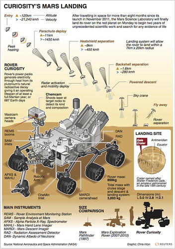
It was, in fact, cool, because Curiosity — a car-size mobile laboratory that’s bigger and more advanced than any of its predecessors — finished its 104 million-mile journey with a landing as dramatic as it was improbable. The touchdown required an extraordinary sequence of events designed to slow the incoming spacecraft from a blistering 13,000 m.p.h. to 2 m.p.h. in just seven minutes. Among the new tools in play: a 51-ft.-diameter parachute with eight suspension lines — the biggest ever used in an extraterrestrial landing — and retrorockets designed to slow the craft almost to a hover. Then there was the little matter of the spacecraft’s transforming itself into a sky crane just prior to landing, using nylon cords to lower Curiosity the final 25 ft. to the ground.


As it turned out, the much-hyped “seven minutes of terror” that began when the spacecraft entered the Martian atmosphere instead became seven minutes of breathless cheers — guided entry, parachute deployment, heat-shield separation — passed by uneventfully.

“Standing by for sky crane,” announced flight-dynamics engineer Al Chen, who provided commentary from the mission control room. The awaited terror finally hit; the lab fell silent. Then, after a slight pause, Chen’s smooth voice returned. “Touchdown confirmed!” he shouted at 10:32 p.m. Pacific time.

The scientists and engineers, many of whom spent 10 years working on the mission, burst into cheers and even tears as the tense seven minutes gave way to 15 jubilant minutes.

With the theatrics done, Curiosity is now set to begin a 98-week mission — one Martian year — hunting for signs that Mars offers, or once offered, a home for microbial life.

Engineers intentionally risked landing the rover inside a crater rather than in a safer, wide-open flood plain for good reason: a plain is, well, plain. Instead, NASA has for the first time placed a rover inside a geological treasure trove.

Gale Crater is a hole next to a mountain, and as we’ve all known since the first time we stepped into a puddle, water and water-driven sediment tend to gather in holes. There will surely be no water around today, but the chemical evidence of it — and perhaps even of the biology it may once have supported — should remain. The proximity of Mount Sharp, just 6 miles away, provides an entirely different kind of scientific target: a heap of layered sediment some two-thirds the height of Mount Everest. That could prove to be an open geological book, with millions of years’ worth of Martian strata on display.

NASA plans to send the probe as far as 12 miles from the landing site, grinding up soil samples and analyzing atmospheric conditions as it makes its way up the mountain.


“We’re hoping to find materials that interacted with water,” says John Grotzinger, the mission’s project scientist and a geologist at the California Institute of Technology.

Of course, if someone dropped you onto another planet, you’d have your smart phone snapping photos the second you arrived. That’s exactly what Curiosity did, in the form of the black-and-white thumbnail images it sent to Earth just minutes after landing. But those pictures aren’t souvenirs. They’re hazcam (hazard-avoidance camera) images that scientists will study to spot any potential obstructions that could hamper movement.

They also want to take time to ensure that no technical problems will prevent Curiosity from extending a vertical “lookout mast” that is loaded with additional cameras and will reach a height of about 7 ft. above the surface.

For Mars aficionados, the first of those milestones are the color pictures, which should arrive on Earth a day after landing. Shot from the rover’s Descent Imager, the photos were taken as the rover approached the surface of Gale Crater and will show the first-ever view aboard a spacecraft landing on Mars. They will also help scientists pinpoint the lander’s location.


Curiosity’s main eyeballs will open up once the mast is extended, which could happen as early as three days after landing. That’s when four navigation cameras (navcams) will begin taking 1-megapixel stereo pictures in a 360-degree circle around the rover. The navcams are designed to look in all directions — including up and down — and have a enough resolution to spot the equivalent of a golf ball 27 yards away. Navcam images will not only give a 3-D view but also help scientists and engineers decide where they want to drive the rover and what surface features to study.

Thankfully, Curiosity is much more than a mechanical paparazzo. The instrument suite is 10 times as massive as any previous rover’s, led by a robotic arm that is part spectrometer, part rock imager, part chemistry lab. Curiosity’s deck harbors an interplanetary CSI lab capable of separating gases or heating powdered samples to identify organic compounds.

And atop the mast, in addition to the bristle of cameras, is an instrument that can fire a million-watt laser beam at rocks up to 23 ft. away, vaporizing them enough for an onboard spectrometer to analyze light from the pinhead-size sparks the rocks will give off, revealing their chemical composition.

Shooting X-rays at nearby rock samples, another task on the agenda, will excite electrons into fingerprint-like signals that identify minerals. “With X-ray diffraction, we can really nail down what kind of clay mineral is there and how those rocks have formed,” says Crisp. Finally — and most tantalizingly — Curiosity will sniff the Martian sky for atmospheric methane, a telltale hint of current organic life.

Engineers say the rover should have an easier time maintaining power than its predecessors, which suffered from dust accumulating atop their solar panels. Curiosity relies on a shoebox-size nuclear generator that turns heat generated by decaying plutonium into electrical power for the onboard batteries.