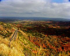
A visit to Palo Duro Canyon State Park is a treat. The gigantic walls of the ancient site are awe-inspiring. The small river in the bottom of the canyon is the Prairie Dog Red. It is the mother stream that becomes the Red River. Here's a profile:
Red River (USA)
Western tributary of the Mississippi River, USA, 1,638 km/1,018 mi long; so called because of the reddish soil sediment it carries. Formed in Oklahoma by the confluence of the North Fork and the Prairie Dog Town Fork, it flows through Texas, Arkansas, and Louisiana, before entering the Mississippi near Baton Rouge, about 500 km/310 mi above the Gulf of Mexico. The stretch that forms the Texas–Oklahoma border is called Tornado Alley because of the storms caused by the collision in spring of warm air from the Gulf of Mexico with cold fronts from the north. The largest city on its course is Shreveport, Louisiana.
The Prairie Dog Town Fork rises in Staked Plains, Texas, and passes through Palo Duro canyon, 160 km/100 mi long and 300 m/984 ft deep.
© Research Machines plc 2005.
The evocative photo is by rambling Shreveporter Mike Rosebery.
Subscribe to:
Post Comments (Atom)

No comments:
Post a Comment