GPS, the Global Positioning System, works well when all the satellites are functioning. There are many reasons why a satellite might be out of service, however. How do ships and airplanes find their longitude when the GPS is malfunctioning?
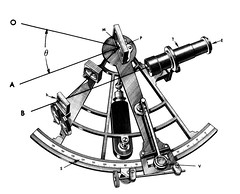
Sextant and chronometer.
A sextant, says Wikipedia.org, is an instrument generally used to measure the altitude of a celestial object above the horizon. Making this measurement is known as sighting the object, shooting the object, or taking a sight. The angle, and the time when it was measured, can be used to calculate a position line on a nautical or aeronautical chart. A common use of the sextant is to sight the sun at noon to find one's latitude.
A chronometer is a watch tested and certified to meet certain precision standards. The marine chronometer was invented by John Harrison in 1730. It enabled accurate marine navigation. For the next 250 years, an accurate chronometer was essential to any kind of marine or air navigation until the implementation of global satellite navigation at the end of the 20th century.
skip to main |
skip to sidebar
For students and parents who love education and exploration of the social sciences . . .
Search This Blog
Followers
Blog Archive
-
▼
2009
(379)
-
▼
August
(38)
- This week's music in World Geography: early jazz f...
- Graphing US demographics: ethnic breakdown
- The background of place names such as York
- River studies: journey up the Hudson with a NY Tim...
- A highly-recommended source for Magnet social stud...
- Project due Tues, Sept 8: Comparing the Erie Canal...
- Water giveth, water taketh away: week of Aug 31 to...
- Water and wealth: the story of the Erie Canal
- Matterhorn: The Alps IMAX film opening September 5...
- Longitude: what if the GPS satellite is out of com...
- A suburb of London called Greenwich, England: Lati...
- The Hydrologic cycle: condensation, precipitation,...
- Rivers equal wealth
- Ramadan: across the globe, one billion people are ...
- Latitude & Longitude: a review of the geography cl...
- Pratt Industries paper recycling plant on the Red ...
- The culture of the Miss River valley: Raising Cane...
- When a project or an essay is due via Google Docs ...
- A slow-moving internet: the Mississippi River and ...
- Preventing unwanted bleeding: the rubric for essay...
- Choctaws: one of the Native American tribes that m...
- Mr Mimal, mnemonics and map quizzes
- Discriminating between the avocado that needs more...
- From Minnesota to the Gulf of Mexico: the Mississi...
- Thirsty issues in your future: water supplies and ...
- Parent signature to show awareness of Mondotrudeau...
- The value in geography class is not in the facts
- An overview of Trudeau's world geography class in ...
- Your questions and input are valued in World Geogr...
- Personal computer classroom policy
- Typical Open Notes quiz: Obama biography
- Geography class homework: reading the notes posted...
- Scrumptious to bizarre: Comparison essay guidelines
- Establishing a gmail.com account for submitting pa...
- World geography / Robert Trudeau / materials 09 - 10
- Geography class syllabus / unit schedule 09 - 10
- Caddo Schools' calendar for 09-10
- LSUS Animation & Visual Effects open house Mon, Au...
-
▼
August
(38)
