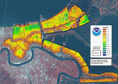
LIDAR map of New Orleans flooding from Hurricane Katrina
Originally uploaded by GISuser.com GIS and Geospatial Technology News
- French Quarter / Vieux Carre ("old section")
- Uptown neighborhood / affluence and mansions along St Charles Ave.
- University section: Tulane, Loyola U, Xavier U., Dillard U.
- Central Business District (CBD); nearby is the Superdome
- Metairie
- Lake Pontchartrain
- UNO, SUNO
- Industrial canal (ship channel)
- 9th ward
- Chalmette (Battle of NO)
- Gentilly
- West Bank area (Algiers, Kenner)
- Slidell (across L. Pontchartrain)
* Times-Picayune slide show (Nola.com).
* picayune - something of little value / a penny coin.
* croissant - crescent-shaped roll
* Gulf Coastal Plain - geographic region in which we live.
*
