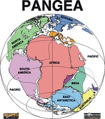
Pangaea, or Pangea, - from παν, pan, meaning entire, and Γαῖα, Gaea, meaning Earth in Ancient Greek - was the supercontinent that existed during the Paleozoic and Mesozoic eras about 250 million years ago, before the component continents were separated into their current configuration [2].
The name was first used, says Wikipedia, by the German originator of the continental drift theory, Alfred Wegener, in the 1920 edition of his book The Origin of Continents and Oceans (Die Entstehung der Kontinente und Ozeane), in which a postulated supercontinent Pangaea played a key role.
Paleogeographic reconstructions show Pangaea as a roughly C-shaped landmass that was spread across the equator. The body of water that was enclosed within the resulting crescent has been named the Tethys Sea. Owing to Pangaea's massive size, the inland regions appear to have been very dry. The large supercontinent would potentially have allowed terrestrial animals to migrate freely.
The vast ocean that surrounded the supercontinent of Pangaea has been named Panthalassa, which means "all seas". The break-up of Pangaea began about 180 million years ago in the Jurassic Period. First it separated into two supercontinents (Gondwana to the south and Laurasia to the north), thereafter into the continents we have today.
Subscribe to:
Post Comments (Atom)

No comments:
Post a Comment