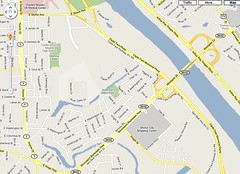
Classes are reviewing the 5 Themes of Geo and the mapping sensibility that accompanies the sense of place, location, region, movement and human-environment interaction.
On this map students will be able to sketch and identify -
Red R.
Teague Parkway
Fant Parkway
Stoner Ave
Youree Dr
Olive St
Magnet / Valencia Park
Students were helped in adding
Stoner Hill Elem
Montessori School for Spt
and identifying a North-South open space on the river side of three schools: Magnet, Stoner Elem and MSS. This area, blank on the map, is an old river bed.
When the Great Raft clogged the main body of the Red River, side channels were developed. This open space / wooded bottom was a loop of the river. The neighborhood called Anderson Island was created by this and other loops of the Red.
This wooded area is being developed into a greenway or nature trail by a civic group called A Better Shreveport. The person who identified this area was nature education specialist Jon Soul of Montessori. .
skip to main |
skip to sidebar
For students and parents who love education and exploration of the social sciences . . .
Search This Blog
Followers
Blog Archive
-
▼
2010
(346)
-
▼
September
(42)
- Magnet recycling is back, courtesy of pick-up and ...
- Another way to earn Indie points: an essay on a vi...
- The California Map Project - test your peers and f...
- Indie work: integrating the bios of Leo Fender and...
- John Muir, father of the national parks and Sierra...
- Our mission: Be responsible, respectful and seek e...
- Tectonica: last week's quiz and the source of the ...
- California Dreamin: songs about the Golden State
- Topics in the California Project
- A Walk in the Garden: Talent Show on Fri, Sept 24,...
- Getting to know the Pacific rim: California quiz
- The glories of the Golden State, California
- Sustainability: a key term for the coming generations
- A pre-quiz quiz: more tectonics
- The science and medical research that explains the...
- Plates that will crack in a spectacular and nation...
- World geography project: what's inside Spaceship e...
- Indie work - comparison essays
- Pratt Industries: recycling for Shreveport and man...
- Mary Bennett Cane, Shreveport's first important bu...
- Cyberbullying an issue in Upfront magazine: "Techn...
- Demographics, the study of populations
- Guidelines for comparison essays in geography clas...
- Indie work: comparing Henry Miller Shreve and Lark...
- Open notes quiz Tues/Wed: 5 themes of geography an...
- Cochon de lait is the Cajun French term for a pig ...
- Shreveport in Place and Location: the Texas Trail ...
- Syllabus, Magnet geography / Trudeau / 2010-2011
- Quiz #2: Hydrologists & Kinesiologists
- Henry Miller Shreve, the steamer & flat boat and a...
- Coates Bluff Nature Trail, adjacent to Magnet, Sto...
- Mapping overview / East Shreveport; Magnet and nei...
- Reviewing the 5 Themes of Geography
- Stoner Ave at Fant Parkway: Riverscape development...
- Back to school night: Thurs, Sept 9, 5:30 pm
- Class of 2014 Speed Meet on Fri, Sept 10, 6:30 - 8...
- Sketching / mapping the Magnet campus
- Bees at RW Norton Art Foundation, Shreveport; why ...
- Because of the British Empire, we look for this si...
- Indie work (independent): building bonus points an...
- No question that Otzi's an indigenous fellow
- 5 Themes of Geography / Shreveport Bossier
-
▼
September
(42)
