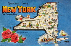
Instead of sketching a map of Manhattan and neighbors, the class sketched the state of New York, known as the Empire State.
Included:
Lake Erie
Lake Ontario
St Lawrence Seaway
Canada
Erie Canal
Hudson R.
Atlantic
Connecticut
New Jersey
Pennsylvania
Long Is.
Albany
The economic power of NYC is based largely on the port of NY. With this map you will see an additional factor in New York's economic development.
It concerns a gamble and investment made by NY in the 1800's: it is the Erie Canal. If you connect the Hudson River to the Erie Canal, which connects to the Great lakes and the resources of upper middle America - along all the Great Lakes - you have a gigantic economic development.
Speaking of rivers: what evidence have we seen that shows the Red River to be an economic force?
- Pratt Industries / paper recycling
- La Boardwalk
- casino gambling boats
Subscribe to:
Post Comments (Atom)

No comments:
Post a Comment