Th, Sept 4
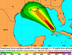
Storm map project:
Sketch, label and color -
- Fla
- Al
- Ms
- La
- Tx
- Mexico
- Yucatan Peninsula
- Cuba
- Haiti / Dominican Republic (Santo Domingo is the capital city).
- Gulf of Mexico
- Caribbean
From the Ocean Currents map (see earlier post) -
- Canary Current
- Equatorial Current
The lesson: "Recognizing connections over vast distances - such as linking Africa and Louisiana via weather - enables students to understand global dynamics. Think big."
Subscribe to:
Post Comments (Atom)


No comments:
Post a Comment